
Stoney Point (California) facts for kids
Quick facts for kids Stoney Point Outcroppings |
|
|---|---|

Stoney Point
|
|
| Location | Chatsworth Park North, Chatsworth, Los Angeles, California |
| Area | Santa Susana Mountains |
| Architect | None |
| Architectural style(s) | None |
| Governing body | City of Los Angeles Department of Recreation and Parks |
| Designated | November 20, 1974 |
| Reference no. | 132 |
| Lua error in Module:Location_map at line 420: attempt to index field 'wikibase' (a nil value). | |
Stoney Point, also known as the Stoney Point Outcroppings, is a cool park in Chatsworth, Los Angeles, California. It's part of the big city of Los Angeles. You can find it near the north end of Topanga Canyon Boulevard.
Stoney Point is a popular spot for many outdoor activities. People love to go hiking and horseback riding here. It's also a favorite place for rock climbers because of its huge boulders. These rocks are perfect for practicing a type of climbing called bouldering. From the top of the rock formations, you can see amazing views of Chatsworth, the Santa Susana Mountains, and the whole San Fernando Valley.
You might spot some wildlife at Stoney Point, like coyotes, rattlesnakes, and different kinds of birds such as red-tailed hawks and golden eagles. Rabbits and skunks also live here. If you bring a dog, make sure to keep it on a leash to keep it safe.
Contents
What is Stoney Point Made Of?
Geologists, who study rocks and the Earth, call Stoney Point the Chatsworth Formation. These giant rock formations are found in the Simi Hills. They are very, very old, more than 65 million years old! This means they formed during the Upper Cretaceous period, when dinosaurs were still around.
How the Rocks Formed
These rocks started forming deep in the Pacific Ocean. They might have been near Central America or even Baja California. They were created by something called turbidity currents. Imagine giant underwater landslides that carried sand and dumped it on the ocean floor, about 4,000 to 5,000 feet deep. These currents were huge, sometimes many miles long and half a mile wide! This explains why the mountains around the Chatsworth Formation are so big.
In between these big sand slides, fine silt from the ocean would settle. Since silt wears away faster than sand, you can actually see the different layers left by the turbidity currents in the rocks today.
Stoney Point's Journey
The Chatsworth Formation is part of the Pacific Plate. This huge piece of the Earth's crust is slowly grinding against the North American Plate. Because of this, Stoney Point is slowly being pushed northwest about 2.5 inches every year! Over millions of years, the Chatsworth Formation was pushed out of the ocean and became part of the Transverse Ranges. Because of all this movement, most fossils that might have been in the ocean were crushed, so you won't find many here.
The rocks are made of sandstone, which is a medium-grained type of rock. It was originally light gray. But over time, the mica and clay inside the rock react with air and turn a tan color. Some parts of the Chatsworth Formation are still light gray because they haven't changed color yet.
A Look Back in Time at Stoney Point
Stoney Point has a long and interesting history.
Native American History
For a very long time, until the 1790s, Stoney Point was home to the Tongva Native American people. It's believed that a village called Momonga was located right here. This village was special because people from different tribes, like the Chumash, Fernandeno, and Gabrieleno, lived together and even married each other.
There's also a sulphur spring next to Stoney Point Park. People believed this spring had spiritual powers. It's said that shamans (spiritual leaders) would visit Stoney Point to get ready for the Winter Solstice celebration. Native people would travel from far away to attend this important event.
Early Uses of the Area
In the 1870s, it's said that an outlaw named Tiburcio Vasquez used Stoney Point as a hideout.
Later, the Southern Pacific Railroad used Stoney Point as a marker when they were building train tracks through the Santa Susana Mountains.
Stoney Point: A Special Place
Stoney Point was officially named a Los Angeles Historic and Cultural Monument in 1974. This was because of its important history and culture, and also because it's considered one of the most beautiful places in Los Angeles.
The park covers 81 acres of land. This includes a five-acre equestrian center, which is a place for horses. The City bought this center in 2007. Every spring, the Chatsworth Neighborhood Council hosts the Annual Chatsworth Day of the Horse Festival here.
The Charlton Quarry
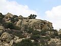
During a time when people were claiming land, the Charlton Family from New York claimed Stoney Point. It became the site of the Charlton Quarry, one of three quarries in Chatsworth. A quarry is a place where stone is dug out of the ground. Here, "Dimension Stone" was quarried, meaning large blocks of stone were cut out. This stone was used to build the nearby train tunnel. You can still find parts of the old quarry on the eastern side of Stoney Point, along the Santa Susana Creek.

Railroad Stories at Stoney Point
Stoney Point is an important spot along the Southern Pacific Railroad line. This railroad connects much of Southern California to Northern California. Stoney Point is located at the bottom of the Simi/Santa Susana Grade, which is a sloped part of the track. The stone dug from Stoney Point was used to build Chatsworth's train tunnels.
Changes to the Land
When the Gabrielino-Tongva tribe and missionaries lived here, the land was great for farming. They grew fruits, vegetables, wheat, and barley. But when the railroad was built, the heavy iron tracks and constant digging changed the natural land. Forests and plants had to be cleared to lay the tracks. Native Americans were also forced to move from their homes. They lost their fertile soil and good irrigation systems.
After the year 1900, dry farming started again, and much of the land around Stoney Point was planted with citrus and olive trees. Today, the area around Stoney Point has many horse boarding stables and homes for people who own horses.
Train Whistles and Trails
Because of a blind curve caused by Stoney Point's rocks, train engineers used to blow their whistles loudly as they approached. Residents complained about the noise. Now, engineers blow the whistle either from the Chatsworth train depot or after they leave the tunnel at the top of the grade.
There's a path that connects Rinaldi Street to Andora Avenue by crossing the railroad tracks. This path was once called the "Old Mission Trail" and was the main way to get to the San Fernando Mission from Chatsworth. It later became known as North Andora Avenue, and then the street name changed to Rinaldi. But a path for horses (an equestrian easement) still remains. In 1998, a local council member helped keep this path open for the community when the MTA (Metropolitan Transportation Authority) tried to close it.
In 2001, the MTA cut down old Eucalyptus trees along the railroad tracks at Stoney Point. They did this because they were worried the trees might fall onto the tracks and hurt park visitors.
A Sad Event
On September 12, 2008, a Metrolink commuter train crashed into a cargo train. This was a very sad event, and it was one of the worst train accidents in U.S. history in over 40 years. The crash happened on the northeast side of the park, and you can reach the site through the park. In September 2009, a memorial was held at Stoney Point, and a marker was placed to remember those who were lost.
The Gabrielino-Tongva People at Stoney Point
The Gabrielino-Tongva (also called Gabrielino) Native Americans lived at Stoney Point starting around 6000 BC. Their homeland had lots of natural resources and a good system for trading. This tribe was known for being skilled hunters and gatherers. They found plenty of food from animals and plants all year round, depending on the season and location. For example, rabbits, roots, and shellfish were always available. Some foods, like acorns, were collected in large amounts once a year. In winter, inland communities sometimes had less fresh plant food, but coastal communities had plenty of marine food.
Living with Nature
The Gabrielino people had many different resources because their land included various natural areas. These included beaches, coastal regions, fresh and saltwater areas, chaparral (shrubland) and grassland zones, and even woodlands and mountains. They hunted land mammals, fish, insects, reptiles, and sea-mammals. They gathered trees, plants, seeds, and bulbs. They also found minerals like obsidian and chert to make tools and sticky compounds. All these resources helped the Gabrielino people meet their needs.
The Gabrielinos ate a balanced diet by using the resources available at different times of the year. They were excellent hunters who used their tools and skills wisely. They hunted meat more in the winter when fresh plants were scarce. Fishing and sea-mammal hunting happened in the spring and summer.
Sharing and Respecting Resources
The Gabrielino Indians believed that being greedy and hoarding food was wrong. They managed their food resources carefully. For example, fishermen and hunters were not allowed to eat their own catch. This helped make sure everyone shared. At certain times of the year, many people would gather to collect seasonal crops or work together on large hunts. It was important for everyone in the village to help harvest seeds from the plains.
The Gabrielinos tried to have a very small ecological footprint, meaning they tried not to harm the environment. They were very interested in the spiritual world. Shamans in their communities would help understand the environment. They believed the universe was always changing, which made them want to protect the environment and its resources. They looked to shamans to keep the universe in balance and to perform sacred rituals.
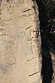
The main way they left a mark on the land was through rock art, which didn't harm the environment. They used two methods: petroglyphs (carvings in rock) and pictographs (paintings on rock). You can see a petroglyph of a rabbit or squirrel in one of the pictures here. Most of this art was made during special ceremonies. Later generations have kept some of this artwork in museums. You can still visit some ancient rock art sites of the Gabrielino Indians around Stoney Point.

You can still find water collection basins and mortars (bowls for grinding nuts and seeds) on the highest boulders at Stoney Point.
The Arrival of Europeans
It wasn't until the Spaniards built the California Missions starting in 1769 that the Native Americans lost their land. The land was then turned into areas for settlers. The creek bed on the west side of Stoney Point was the western border of the San Fernando Mission. By 1834, Ranchos (large farms) were also being created on Native American land. The building of railroads and other forms of industrialization by settlers caused the most harmful changes to the land around Stoney Point.
Stoney Point in Movies and TV
Stoney Point has been a popular filming location for many movies and television shows, even since the time of silent films. Shows like Seinfeld and CSI: Las Vegas have used Stoney Point as a backdrop.
Rock Climbing at Stoney Point
Rock climbing started at Stoney Point in the 1930s. Young climbers from the Sierra Club discovered it. In the 1950s and 60s, famous climbers like Royal Robbins and Yvon Chouinard learned to climb here. Other well-known climbers such as Bob Kamps, Ron Kauk, John Long, and John Bachar also started their climbing journeys at Stoney Point.

From 1959 to 1995, Bob Kamps, one of America's best climbers, was often seen climbing on Tuesdays and Thursdays. He was always happy to teach others. Another amazing free-solo climber, Michael Reardon, also climbed here.
In the 1970s, a group of climbers called the Stonemasters, who wanted to make their mark on rock climbing, also spent a lot of time at Stoney Point.
Stoney Point has a long history with rock climbing and bouldering. However, not many "first ascents" (the first time someone successfully climbs a route) are officially recorded here. This might be because it's seen more as a practice area than a place for new, challenging climbs.
Climbing Conditions
The rock at Stoney Point is sandstone. This type of rock is softer on the hands when you're bouldering, so climbers can practice for longer without as much pain. But after it rains and the rock gets soaked, parts of it can break off easily. Stoney Point doesn't close when it rains, but climbers are advised to be extra careful. Otherwise, you can climb at Stoney Point all year round. Some people have sadly chipped away at the easy-to-break rock to create their own handholds, which other climbers do not approve of.
There are many different bouldering routes to choose from, ranging from easy to very hard. These are rated using systems like the Yosemite Decimal System for rock climbing and the Hueco scale for bouldering. Both beginners and advanced climbers can find something to challenge them among the more than 150 routes available.
Popular Bouldering Areas
- Boulder 1 area: Features famous bouldering climbs like "Leaping Lizards," "Yabo's Mantle," and "Three Pigs."
- Pile Ups: Offers a climb that goes across the edge of the boulder.
- Turlock: This area has "highball" bouldering, which means the climbs are very tall. There's an anchor on top for climbers who use ropes. Famous climbs here include "Crowd Pleaser" and "Crystal Ball."
- B1 Boulder: Has very difficult climbs such as "Master of Reality" and "The Crack."
Images for kids
-
Remnants from the Charlton Quarry
-
Ancient petroglyph on east side of Stoney Point
-
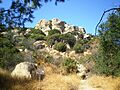
Climbers at Stoney Point
