Syringa, Idaho facts for kids
Quick facts for kids
Syringa, Idaho
|
|
|---|---|
| Country | United States |
| State | Idaho |
| County | Idaho |
| Lowest elevation | 1,411 ft (430 m) |
| Time zone | Pacific (UTC-8) |
| ZIP code |
83539
|
| Area code(s) | 208 |
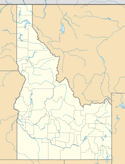
Syringa is a small community in the northwest United States. It is located in Idaho County, Idaho. The community gets its name from the Syringa shrub. This plant, Philadelphus lewisii, is the state flower of Idaho. Syringa is in the Pacific Time Zone. The weather here is mild because it is not very high up. It gets more than 25 inches (63.5 cm) of rain each year.
Syringa's Location and Land
Syringa sits at the base of the Clearwater Mountains. These mountains are part of the larger Rocky Mountains. The community is right along the Middle Fork of the Clearwater River. This area is near the edge of the Idaho Batholith. Huge lava flows, called the Columbia River Basalt Flows, are just a few miles west.
Three creeks flow into the Clearwater River near Syringa. These are Little Smith Creek, Smith Creek, and Syringa Creek. They join the river very close to each other. This creates a large flat area of land. This area is surrounded by beautiful forests.
Syringa's Past
This land was once the home of the Nez Perce people. They call themselves Nimi’ipuu (Nee-me-poo). Syringa is about 11 miles (18 km) east of their current reservation. The Lewis and Clark National Historical Trail is about 10 miles (16 km) north. This trail is also known as the Northern Nez Perce Trail.
In 1877, during the Nez Perce War, the Nez Perce used this trail. They were trying to escape from General Oliver Howard. Settlers began moving into the area in the 1880s. Homesteads, which are family farms, were set up in the early 1900s.
Long ago, cutting down trees for wood was the main job here. Today, people focus on outdoor fun and managing the land. The Middle Fork Ranger station was located nearby until 1939. Big fires have also shaped the area's history. These include the Great Fire of 1910, also called the Great Burn, and the Pete King Fire of 1934. The Woodrat Fire also threatened Syringa in 2015.
Syringa's Geography
Syringa is located between 1,411 and 1,430 feet (430 to 436 meters) above sea level.
The main way to reach Syringa is by U.S. Route 12. This road is part of the Northwest Passage Scenic Byway. It is one of three main roads that cross Idaho from east to west. Syringa is inside the Middle Fork Wild and Scenic River Corridor. The U.S. Forest Service manages this area.
The community is surrounded by large forests. These include the Clearwater National Forest and the Nez Perce National Forest. These two forests are now managed together. To the east is the Selway Bitterroot Wilderness Area. Syringa is part of the Mountain View School District #244. Students travel by bus to Kooskia, Idaho, for school. The phone area codes for Syringa are 208 and 986.
Syringa's Weather
The weather in Syringa is much like that in Kooskia. Kooskia is about 15 miles (24 km) to the west. However, Syringa has a slightly shorter time for plants to grow. The valley is low in elevation. Its mountains are lined up in a way that gives Syringa mild and moist weather.
Many types of trees grow well here. These include white and red fir, Western red cedar, and Ponderosa pine. Cottonwood trees grow close to the creeks. Ferns and other small plants can grow very thick. This is especially true on the north-facing slopes.
 | Georgia Louise Harris Brown |
 | Julian Abele |
 | Norma Merrick Sklarek |
 | William Sidney Pittman |


