
Ténéré facts for kids
Quick facts for kids
Ténéré
Tiniri
|
|
|---|---|

A dune sea (Erg) between Fachi and Bilma.
|
|

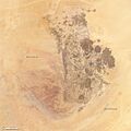
Map of the Ténéré - Aïr Natural Reserve area.
|
|
| Countries | Niger and Chad |
| Area | |
| • Total | 400,000 km2 (200,000 sq mi) |
| Elevation | 430 m (1,410 ft) |
The Ténéré (pronounced Teh-neh-RAY) is a huge desert area in the central part of the Sahara Desert. It stretches across northeastern Niger and into western Chad. This vast sandy plain covers more than 400,000 square kilometers, which is larger than many countries!
The Ténéré is surrounded by mountains: the Aïr Mountains to the west, the Hoggar Mountains to the north, and the Tibesti Mountains to the east. To the south, it reaches the area around Lake Chad. In the middle of this desert, you'll find the Erg of Bilma, which is a large area filled with amazing sand dunes. Long ago, a very old human culture, called the Tenerian culture, lived here.
Discovering the Ténéré Desert
What's in a Name?
The name Ténéré comes from the Tuareg people. It simply means "desert." This is similar to how the Arabic word Sahara also means "desert" and is used for the entire region.
A Land of Extreme Climate
The Ténéré has a very hot and dry climate, just like much of the Sahara Desert. It's extremely sunny and dry all year, with almost no plants growing. Average high temperatures often go above 40 °C (104 °F) for several months. Sometimes, temperatures can even reach 50 °C (122 °F) in the summer! Even in "winter," the average high temperatures are usually around 30 °C (86 °F).
Rainfall here is incredibly rare. The Ténéré gets only about 10 to 15 millimeters (less than an inch) of rain each year. Often, several years can pass without any rain at all. Finding water is very difficult, even underground, and wells can be hundreds of kilometers apart.
The sun shines for about 4,000 hours a year in the Ténéré. This means it's sunny for about 91% of the daylight hours! This makes it one of the sunniest places on Earth. The Ténéré is truly one of the most extreme environments on our planet.
Exploring the Ténéré Landscape

Most of the Ténéré is a flat area. Long, long ago, it was actually the bottom of a huge prehistoric lake, similar to Lake Chad. In the northern part, the Ténéré is a vast, flat sheet of sand. This is the truly empty, legendary "Ténéré" that stretches towards the low hills of the Tassili du Hoggar near the border with Algeria.

In the center, you'll find the Erg of Bilma. This area has rows of sand dunes that are easy to travel through. These natural paths are often used by azalai, which are traditional salt caravans. To the west, the Aïr Mountains rise up, offering a different kind of landscape.
To the southeast, the Ténéré is bordered by the Kaouar cliffs. These cliffs run for 100 kilometers from north to south. At their base, there's a line of oases, including the famous Bilma. You might also spot rare landmarks like the unique marble Blue Mountains in the northwest or the Agram hills near the oasis of Fachi.
Ancient History of the Ténéré
The Ténéré has a fascinating past.
Dinosaurs and Early Humans
Millions of years ago, during the Carboniferous period, this region was covered by the sea. Later, it became a lush tropical forest! Today, a major dinosaur burial ground is located southeast of Agadez, at a place called Gadoufaoua. Many fossils have been found there. Scientists discovered an almost complete skeleton of a huge, crocodile-like reptile called Sarcosuchus imperator, which they nicknamed the SuperCroc!
Humans have lived in this area for a very long time. Modern humans were here as far back as the Paleolithic period, about 60,000 years ago. They hunted wild animals and left behind stone tools, including tiny, carefully made arrowheads. Around 10,000 years ago, during the Neolithic period, ancient hunters from the early Holocene Kiffian people created amazing rock engravings and cave paintings. You can still find these ancient artworks across the region today.
A Wetter Past

From about 7,500 BC to 3,000 BC, the Ténéré experienced a much wetter period. This time is known as the Neolithic Subpluvial. During these years, northern Africa received a lot more rain. Many archaeological sites from this period, often linked to the Tenerian culture, are found in the deserts near the borders of Niger, Algeria, and Libya. As the Sahara became drier again, the human population slowly decreased. By 2500 BC, the desert was largely as dry as it is today.
Remembering a Tragic Event

On September 19, 1989, a passenger plane, McDonnell Douglas DC-10 UTA Flight 772, crashed in the desert near Bilma, Niger. All 170 people on board, including 156 passengers and 14 crew members, tragically lost their lives. This was a very sad event for the region. A special memorial was later built in the desert to honor those who passed away.

People of the Ténéré

The Ténéré is a very sparsely populated place. Only a few settlements, like Fachi and Bilma, are found deep within the desert.
The well-known Tuareg live in the Aïr Mountains and around Agadez to the west. They continue to organize traditional salt caravans for Hausa merchants. Other groups, like the Kanuri and Toubou, live in oases further east, such as Fachi.
Protecting the Ténéré
In 1960, the Tuareg territory became part of the newly independent country of Niger. Today, the central part of the Ténéré is a protected area. It is part of the Aïr and Ténéré Natural Reserve, which helps preserve its unique environment and wildlife.
Towns and Oases
The main administrative center for the Ténéré region is the town of Agadez. It's located south of the Aïr Mountains and to the west of the Ténéré itself. There are also several oasis settlements. Some, like Bilma and Séguedine, are famous for their salt production.
Here are some of the towns and villages in the Ténéré:
- Fachi
- Achegour
- Bilma
- Dirkou
- Chirfa
- Agadem
- Séguedine
Famous Ténéré Landmarks

The Ténéré Desert is known for the famous Tree of Ténéré. This tree was once thought to be one of the most isolated trees in the world. It stood by the last well before travelers entered the Grand Erg du Bilma on their way to Fachi. Salt caravans used the tree as an important landmark. Sadly, it was knocked down by a truck driver in 1973.
A metal sculpture now stands in its place. The remains of the original tree are kept safe in a museum in Niamey, the capital of Niger. New trees were planted, but because the water underground is very deep (the nearby well is about 40 meters deep), they didn't survive. Even so, the Tree of Ténéré is still often shown on maps as a notable landmark. Another less known landmark is the Arbre Perdu (Lost Tree) in the northern Ténéré, west of Chirfa.
A special monument for UTA Flight 772 was built in May and June 2007. It is a 200-foot wide circle made of dark stones. Inside, 170 broken mirrors represent each person who lost their life in the 1989 plane crash.
Images for kids
-
Annotated view of the Aïr Mountains.
-
A closer look at the Aïr Mountains.


See also
- Aïr and Ténéré National Nature Reserve
- Germa
- Green Sahara
- Missions Berliet-Ténéré
