Tarawa facts for kids
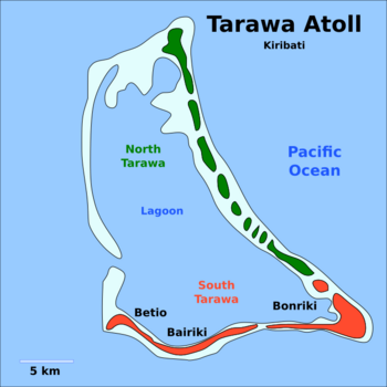
Map of South Tarawa and North Tarawa within Tarawa Atoll
|
|
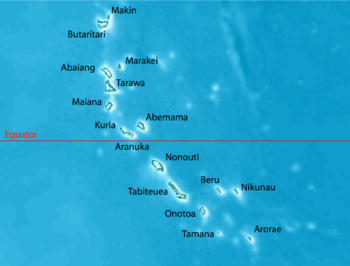
Map of the Gilbert Islands
|
|
| Geography | |
|---|---|
| Location | |
| Coordinates | 1°20′N 173°00′E / 1.333°N 173.000°E |
| Archipelago | Gilbert Islands |
| Area | 31.02 km2 (11.98 sq mi) |
| Highest elevation | 3 m (10 ft) |
| Administration | |
|
Kiribati
|
|
| Island councils | Betio, North Tarawa, South Tarawa |
| Largest settlement | Betio |
| Demographics | |
| Population | 70,480 (2020) |
| Pop. density | 2,031.5 /km2 (5,261.6 /sq mi) |
| Languages | Gilbertese |
| Ethnic groups | I-Kiribati (95.5%) |
| Additional information | |
| Time zone |
|
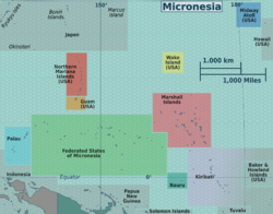
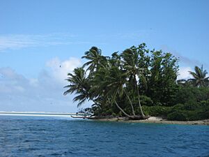
Tarawa is a beautiful group of islands, called an atoll, and it's the capital city of a country called Kiribati. It's located in the Micronesia region of the central Pacific Ocean.
Tarawa is made up of two main parts: North Tarawa and South Tarawa. North Tarawa has about 6,629 people and feels more like other quiet islands in the Gilbert Islands. South Tarawa is much bigger, with about 56,388 people as of 2015. This means half of Kiribati's total population lives there! Tarawa was also the location of a very important battle during World War II, known as the Battle of Tarawa.
Contents
What Does Tarawa Mean?
The name Tarawa comes from an old word in the Gilbertese language, Te Rawa. It means "The Passage" because of a big channel that lets ships into the lagoon.
In Kiribati stories, a god-spider named Nareau created the world. He named the sky Karawa, the sea Marawa, and the land Tarawa.
Exploring Tarawa's Geography
Tarawa has a very large lagoon that covers about 500 square kilometers (193 square miles). It also has a wide reef. The lagoon is open to the ocean with a big passage for ships.
Even though there are lots of fish and shellfish, the growing population is making it harder to find enough. It often gets dry, but usually there's enough rain for breadfruit, papaya, and banana trees to grow, along with coconut and pandanus trees.
North Tarawa's Islands
North Tarawa is a chain of small islands, or islets, stretching from Buariki in the north to Buota in the south. These islets are sometimes separated by wide channels. It's easiest to cross these channels when the tide is low. There's also a ferry service between Buota and Abatao. Only Buota is connected to South Tarawa by a road and a bridge.
South Tarawa's Connected Land
On South Tarawa, many causeways have been built. These causeways connect the islands, creating one long strip of land. This strip goes from Betio in the west all the way to Tanaea in the northeast. Before these causeways, Betio, where the Battle of Tarawa took place, was only about 291 acres in size.
Tarawa's Climate
Tarawa has a tropical rainforest climate. This means it's warm and humid all year round. From April to October, the weather is nice with winds from the northeast and steady temperatures around 30°C (86°F). From November to March, strong western winds bring rain and sometimes even cyclones.
The amount of rain can be very different across the Gilbert Islands. For example, the northern islands get about 3,000 mm (120 inches) of rain each year, while the southern islands only get about 500 mm (20 inches). Many of these islands are in a dry zone, so they can have long periods without rain.
| Climate data for Tarawa Airport (South Tarawa) | |||||||||||||
|---|---|---|---|---|---|---|---|---|---|---|---|---|---|
| Month | Jan | Feb | Mar | Apr | May | Jun | Jul | Aug | Sep | Oct | Nov | Dec | Year |
| Record high °C (°F) | 35.0 (95.0) |
33.0 (91.4) |
35.0 (95.0) |
34.5 (94.1) |
34.5 (94.1) |
33.5 (92.3) |
34.5 (94.1) |
34.5 (94.1) |
34.5 (94.1) |
35.0 (95.0) |
35.0 (95.0) |
35.0 (95.0) |
35.0 (95.0) |
| Mean daily maximum °C (°F) | 30.7 (87.3) |
30.6 (87.1) |
30.7 (87.3) |
30.7 (87.3) |
30.8 (87.4) |
30.8 (87.4) |
30.9 (87.6) |
31.0 (87.8) |
31.1 (88.0) |
31.2 (88.2) |
31.3 (88.3) |
30.9 (87.6) |
30.9 (87.6) |
| Daily mean °C (°F) | 28.2 (82.8) |
28.1 (82.6) |
28.1 (82.6) |
28.2 (82.8) |
28.4 (83.1) |
28.3 (82.9) |
28.2 (82.8) |
28.3 (82.9) |
28.4 (83.1) |
28.6 (83.5) |
28.5 (83.3) |
28.2 (82.8) |
28.3 (82.9) |
| Mean daily minimum °C (°F) | 25.3 (77.5) |
25.3 (77.5) |
25.2 (77.4) |
25.3 (77.5) |
25.5 (77.9) |
25.3 (77.5) |
25.1 (77.2) |
25.2 (77.4) |
25.3 (77.5) |
25.4 (77.7) |
25.4 (77.7) |
25.3 (77.5) |
25.3 (77.5) |
| Record low °C (°F) | 21.5 (70.7) |
22.5 (72.5) |
22.5 (72.5) |
22.5 (72.5) |
21.0 (69.8) |
21.0 (69.8) |
21.0 (69.8) |
21.5 (70.7) |
22.5 (72.5) |
22.0 (71.6) |
22.5 (72.5) |
22.0 (71.6) |
21.0 (69.8) |
| Average precipitation mm (inches) | 271 (10.7) |
218 (8.6) |
204 (8.0) |
184 (7.2) |
158 (6.2) |
155 (6.1) |
168 (6.6) |
138 (5.4) |
120 (4.7) |
110 (4.3) |
115 (4.5) |
212 (8.3) |
2,052 (80.8) |
| Average precipitation days (≥ 0.3 mm) | 15 | 12 | 14 | 15 | 15 | 14 | 16 | 18 | 15 | 11 | 10 | 17 | 172 |
| Average relative humidity (%) | 81 | 80 | 81 | 82 | 81 | 81 | 80 | 79 | 77 | 77 | 79 | 81 | 80 |
| Mean monthly sunshine hours | 220.1 | 192.1 | 207.7 | 201.0 | 229.4 | 219.0 | 229.4 | 257.3 | 243.0 | 260.4 | 240.0 | 189.1 | 2,688.5 |
| Mean daily sunshine hours | 7.1 | 6.8 | 6.7 | 6.7 | 7.4 | 7.3 | 7.4 | 8.3 | 8.1 | 8.4 | 8.0 | 6.1 | 7.4 |
| Source: Deutscher Wetterdienst | |||||||||||||
How Tarawa is Governed
The Tarawa atoll is divided into three areas for local government:
- Betio Town Council (BTC): This covers the island of Betio.
- Teinainano Urban Council (TUC): This stretches from Bairiki to Tanaea. The name Te inainano in the Gilbertese language means "down of the mast," which refers to the atoll's sail-like shape.
- Eutan Tarawa Council (ETC): This is for North Tarawa, also called Tarawa Ieta. It includes all the islets on the east side, from Buota northwards.
South Tarawa is where the capital of the Republic of Kiribati is located. It has been the main center for the Gilbert and Ellice Islands since 1895. The country's parliament, called the House of Assembly, is in Ambo. The State House, where the head of state lives, is in Bairiki. Government offices are spread out from Betio in the southwest to Nawerewere, which is close to Bonriki (where the international airport is) and Temwaiku. Some settlements in North Tarawa include Buariki, Abaokoro, Marenanuka, and Taborio.
International Connections
Tarawa is home to several diplomatic missions, which are like offices for other countries. These include the embassies of China (which reopened in 2020) and Japan (which opened in 2023). There are also high commissions from Australia and New Zealand.
Many United Nations organizations also have a presence in Kiribati. These include UNICEF, UNDP, UNFPA, UNOPS, UN Women, WHO, and FAO.
Tarawa's History
In Kiribati stories, Tarawa was the land before the sky, ocean, and land were separated by Nareau the spider. After naming the sky karawa and the ocean marawa, he named the rock that another god, Riiki, stood on to lift the sky as Tarawa. Nareau then created the rest of the islands in Kiribati and also Samoa.
The Gilbertese people arrived on these islands thousands of years ago. There have been people moving to and from the Gilbert Islands for a very long time.
Scientists have used methods like carbon dating and DNA tests. These show that people settled the Gilbert Islands around 200 BC. The people of Tungaru (the native name for the Gilbertese) are still excellent sailors. They can travel across the ocean in boats they build themselves, using old navigation methods.
Thomas Gilbert, a captain from the East India Company, was the first European to describe Tarawa. He arrived on June 20, 1788, but he did not land on the island. He named it Matthew Island and called the lagoon Charlotte Bay. Captain Gilbert's drawings from 1788 still exist today.
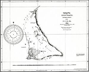
The island was mapped in 1841 by the US Exploring Expedition.
For nine generations, the island was divided between two groups that were often fighting: the House of Auatubu and the House of Teabike. In 1892, a British ship called HMS Royalist (1883) arrived. Captain Edward Davis announced that the island was now a British Protectorate. This helped save the Auatubu group, who had been badly defeated by Teabike the day before. Even after this, there were still many disagreements about land between the two groups for years.
Charles Richard Swayne, the first British official in charge, decided to make Tarawa the main headquarters for the Gilbert and Ellice Islands protectorate in 1895. The Tarawa Post Office opened on January 1, 1911.
Sir Arthur Grimble worked as a young officer in Tarawa from 1913 to 1919. He later became the main British official for the Gilbert and Ellice Islands colony in 1926.
World War II and Tarawa
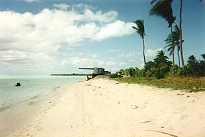
During World War II, Tarawa was taken over by the Japanese. On November 20, 1943, it became the site of a very fierce battle called the Battle of Tarawa. On that day, U.S. Marines landed on Tarawa. They fought against Japanese Marines who were dug into strong positions on the atoll. The U.S. Marines took control of the island after 76 hours of intense fighting. About 6,000 people died in total during this battle.
The intense fighting was shown in a documentary film called With the Marines at Tarawa. This film was made by the photographers of the Second Marine Division. It was released in March 1944 because President Roosevelt insisted on it. For many Americans, it was the first time they saw American soldiers who had died in battle on film. The U.S. also built military bases on the island.
Modern Developments
In 2014, the Kiribati Government started a project to fix and improve the main road on Tarawa. This project was partly paid for by the World Bank. The goal was to make the main road, which goes from Betio in the west to Bonriki in the east, better than a dirt road. By 2018, almost all of the project was finished. The last part, sealing the Japanese Causeway that connects Bairiki and Betio, was completed in 2019.
|
See also
 In Spanish: Tarawa para niños
 | Delilah Pierce |
 | Gordon Parks |
 | Augusta Savage |
 | Charles Ethan Porter |


