
Cyclone facts for kids

In meteorology, a cyclone is a huge swirling mass of air. It spins around a strong center of low pressure.
Cyclones can be very big, like polar vortices or extratropical cyclones. They can also be smaller, like tornadoes or dust devils.
Cyclones can form in different ways. Some, like tropical cyclones, get their energy from warm ocean water. Others, like extratropical cyclones, form when different air masses meet. These powerful weather systems can bring strong winds, heavy rain, and sometimes even tornadoes. They are an important part of Earth's weather, helping to move heat and energy around the planet.
Contents
How is a Cyclone Built?

All cyclones share some basic features. At the very center of a cyclone is an area of the lowest atmospheric pressure. In strong tropical cyclones, this center is called the eye.
The air pressure outside the cyclone is higher than inside. This difference in pressure creates a force that pulls air towards the center. Because of the Coriolis effect (a force caused by Earth's rotation), the winds don't just go straight to the center. Instead, they curve and spin. This spinning motion is what makes a cyclone.
How Do Cyclones Form?


The process of a cyclone forming can happen in different ways, depending on the type of cyclone.
Tropical Cyclone Formation
Tropical cyclones need specific conditions to form and grow. They are "warm-core" storms, meaning their center is warmer than the air around them. Here's what they need:
- Warm Ocean Water: The sea surface temperature must be warm enough, usually around 26.5 degrees Celsius (80 degrees Fahrenheit).
- Unstable Air: The air needs to be able to rise easily.
- Lots of Moisture: High humidity (water vapor) in the air, especially in the lower and middle parts of the atmosphere.
- Coriolis Force: Enough of this force (from Earth's spin) to help the air start rotating. This is why tropical cyclones don't form right at the equator.
- A Starting Point: A small area of low pressure or a disturbance in the atmosphere to get things going.
- Low Wind Shear: Not too much change in wind speed or direction as you go higher in the atmosphere. Strong wind shear can tear a storm apart.
When these conditions are met, warm, moist air rises, cools, and forms thunderstorms. As water vapor turns into liquid (condensation), it releases a lot of heat. This heat makes more air rise, creating a cycle that strengthens the storm.
Extratropical Cyclone Formation
Extratropical cyclones form differently. They start as waves along areas where cold and warm air masses meet. These meeting points are called weather fronts. As the storm grows, these fronts become more defined. A cold front usually moves faster than a warm front. When the cold front catches up, it can create an occluded front, where the warm air is lifted up. These storms are "cold-core" systems, meaning their center is colder than the air around them.
Different Kinds of Cyclones
There are many types of cyclones, from huge systems that cover entire countries to small, short-lived whirlwinds.
Storms Near the Surface
These are the types of cyclones that affect the weather we experience on the ground.
Extratropical Cyclones
An extratropical cyclone is a large low-pressure weather system that forms outside the tropical regions. These are the most common type of cyclone and are responsible for much of the everyday weather in the middle parts of the world. They are linked to weather fronts, which are boundaries between different air masses. These storms bring changes in temperature, rain, and wind. They are often called "depressions" or "lows" by weather forecasters.
Polar Lows

A polar low is a smaller, short-lived low-pressure system that forms over the ocean near the North and South Poles. They were first seen on satellite images in the 1960s. These storms are most active in winter over ice-free parts of the Arctic, like the Norwegian Sea. They usually last only a couple of days and disappear quickly if they move over land. Polar lows can be dangerous for ships and oil platforms in cold regions.
Subtropical Cyclones

A subtropical cyclone is a mix between a tropical cyclone and an extratropical cyclone. They have some features of both. They can form in areas between the equator and about 50 degrees latitude. These storms have wide wind patterns, and their strongest winds are usually farther from the center than in a typical tropical cyclone. They need ocean temperatures of about 23 degrees Celsius (73 degrees Fahrenheit) to form, which is a bit cooler than what tropical cyclones need.
Tropical Cyclones (Hurricanes & Typhoons)
_(cropped).jpg)
A tropical cyclone is a powerful storm system with a low-pressure center and many thunderstorms. These storms produce very strong winds and heavy rain. They get their energy from the heat released when moist air rises and condenses over warm ocean waters. This is why they are called "warm-core" storms.
The word "tropical" refers to where they form, which is usually in the tropical parts of the world. The word "cyclone" refers to their spinning nature. Depending on where they are and how strong they are, tropical cyclones have different names:
- In the Atlantic and Northeast Pacific Oceans, they are called hurricanes.
- In the Indian and South Pacific Oceans, they are called cyclones.
- In the Northwest Pacific Ocean, they are called typhoons.
Tropical cyclones can cause huge waves and dangerous storm surges (a rise in sea level caused by the storm). Their strong winds also make waves bigger, which helps them draw more heat and moisture, making them even stronger. They lose strength quickly when they move over land. This is why coastal areas often get the most damage. However, heavy rains can cause serious flooding far inland. Tropical cyclones also help balance Earth's climate by moving heat and energy from the tropics towards cooler regions.
Storms High in the Sky
Polar Cyclones (Vortices)
A polar cyclone (also known as a polar vortex) is a very large area of low pressure high up in the atmosphere, usually spanning 1,000 to 2,000 kilometers (620 to 1,240 miles). It gets stronger in winter and weaker in summer. In the Northern Hemisphere, the air in a polar cyclone spins counter-clockwise. In the Southern Hemisphere, it spins clockwise. These cyclones are not caused by thunderstorms or meeting air masses like other cyclones. Instead, they are part of the Earth's overall air movement near the poles. When the polar vortex is strong, it keeps cold air locked near the poles. But when it weakens, very cold air can spread to lower latitudes, causing cold weather outbreaks.
Smaller Spinning Storms
These cyclones are much smaller and usually don't show up on big weather maps.
Mesocyclones
A mesocyclone is a spinning column of air, usually 2 to 10 kilometers (1.2 to 6.2 miles) wide, that forms inside a convective thunderstorm. Air rises and rotates around a vertical axis. These are often found in powerful thunderstorms called supercells. Mesocyclones can lead to very strong surface winds, large hail, and are often where tornadoes form. About 1,700 mesocyclones form in the United States each year, but only about half of them produce tornadoes.
Tornadoes
A tornado is a violently spinning column of air that touches both the ground and a cloud (usually a cumulonimbus cloud). They are also sometimes called "twisters." While the word "cyclone" is used more broadly in meteorology for any low-pressure circulation, "tornado" specifically refers to these intense, destructive spinning columns.
Dust Devils
A dust devil is a strong, well-formed whirlwind that picks up dust or sand from the ground. They can range from small (half a meter wide and a few meters tall) to very large (more than 10 meters wide and over 1,000 meters tall). Dust devils usually spin upwards and are generally harmless. However, very large ones can sometimes cause minor damage to property.
Waterspouts
A waterspout is like a tornado that forms over water. In its most common form, it's a non-supercell tornado that connects a cloud to the surface of the water. While often weaker than tornadoes over land, stronger waterspouts can form from mesocyclones.
Steam Devils
A steam devil is a gentle spinning column of air that forms over calm water or wet land. It becomes visible because of rising water vapor.
Fire Whirls
A fire whirl (also called a fire tornado or firenado) is a whirlwind that is created by a fire. It often contains flames or ash and can be quite intense.
-
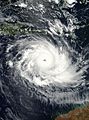
Australian region cyclone
-
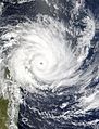
South-West Indian Ocean cyclone

.jpg)


.jpg)


Interesting facts about cyclones

- Henry Piddington was a scientist who studied tropical storms in India in the 1800s. He invented the word cyclone. It means "the coil of a snake," because of how the storms spiral.
- In the Northern part of the world, cyclones spin counter-clockwise.
- In the Southern part, they spin clockwise.
- Cyclones can even form on other planets like Mars, Jupiter, and Neptune.
- The process of a cyclone forming and getting stronger is called cyclogenesis.
- About 86 tropical cyclones form worldwide each year. Around 47 of these become strong enough to be called hurricanes or typhoons. About 20 become very intense, like Category 3 or higher on the Saffir–Simpson hurricane scale.
See also
 In Spanish: Ciclón para niños
