Taylor, Arizona facts for kids
Quick facts for kids
Taylor
|
|
|---|---|
| Taylor, Arizona | |

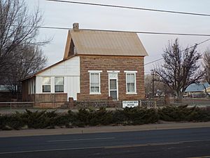
Aguila Standifird House-1890
|
|

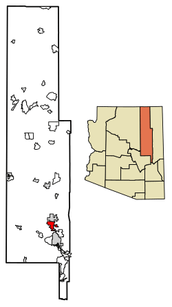
Location of Taylor in Navajo County, Arizona
|
|
| Country | |
| State | |
| County | Navajo |
| Founded by | James Pearce |
| Government | |
| • Type | Council-Manager |
| • Body | Taylor Town Council |
| Area | |
| • Total | 32.69 sq mi (84.65 km2) |
| • Land | 32.66 sq mi (84.60 km2) |
| • Water | 0.02 sq mi (0.06 km2) |
| Elevation | 5,761 ft (1,756 m) |
| Population
(2020)
|
|
| • Total | 3,995 |
| • Density | 122.31/sq mi (47.22/km2) |
| Time zone | UTC-7 (Mountain) |
| • Summer (DST) | UTC−7 (no DST/PDT) |
| ZIP code |
85939
|
| Area code(s) | 928 |
| FIPS code | 04-72420 |
| GNIS ID(s) | 2413369 |
| Website | Town of Taylor |
Taylor is a town located in Navajo County, Arizona, United States. It was started by settlers from The Church of Jesus Christ of Latter-day Saints in January 1878. This was a few months before the nearby town of Snowflake was founded.
Taylor is built along Silver Creek. This creek flows from the nearby White Mountains all the way to the Little Colorado River. The town is part of Arizona's Colorado Plateau. In 2010, about 4,112 people lived there. The town was named after John Taylor, who was an important leader of The Church of Jesus Christ of Latter-day Saints.
One interesting fact about Taylor is that mail is not delivered directly to homes. People who live in Taylor need to get a small PO box at the Post Office for free. They just need to show proof that they live in Taylor. In contrast, people living in Snowflake do get mail delivered to their homes. This can sometimes make it tricky when using services that check postal addresses.
Contents
Railroad History in Taylor
Taylor once had a train line called the Apache Railway. These tracks were built between 1917 and 1920. They connected Holbrook, Arizona (where the Santa Fe Railway was) to Snowflake. From Snowflake, the tracks went through Taylor and continued to the forests at McNary. The part of the line from Snowflake to McNary was no longer used after 1984.
Taylor's Location and Size
The United States Census Bureau says that Taylor covers a total area of about 24.6 square miles (63.7 square kilometers). All of this area is land.
Weather in Taylor
Taylor has four different seasons each year. Summers are warm, and sometimes even hot. Autumns are mild and pleasant. Winters can be mild or cold. Springtime is usually cool and windy.
In July and August, the highest temperatures are often around 90°F (32°C). In December and January, the highest temperatures are usually between 30°F and 55°F (13°C).
| Climate data for Taylor, Arizona | |||||||||||||
|---|---|---|---|---|---|---|---|---|---|---|---|---|---|
| Month | Jan | Feb | Mar | Apr | May | Jun | Jul | Aug | Sep | Oct | Nov | Dec | Year |
| Record high °F (°C) | 79 (26) |
78 (26) |
82 (28) |
92 (33) |
98 (37) |
102 (39) |
104 (40) |
102 (39) |
98 (37) |
90 (32) |
90 (32) |
75 (24) |
104 (40) |
| Mean daily maximum °F (°C) | 48.6 (9.2) |
55.0 (12.8) |
60.8 (16.0) |
68.8 (20.4) |
77.2 (25.1) |
87.3 (30.7) |
90.0 (32.2) |
87.2 (30.7) |
81.7 (27.6) |
71.2 (21.8) |
58.0 (14.4) |
48.9 (9.4) |
69.6 (20.9) |
| Mean daily minimum °F (°C) | 19.6 (−6.9) |
22.9 (−5.1) |
27.7 (−2.4) |
32.7 (0.4) |
39.9 (4.4) |
47.6 (8.7) |
56.2 (13.4) |
55.1 (12.8) |
47.6 (8.7) |
36.0 (2.2) |
26.1 (−3.3) |
19.8 (−6.8) |
35.9 (2.2) |
| Record low °F (°C) | −30 (−34) |
−17 (−27) |
−5 (−21) |
3 (−16) |
17 (−8) |
20 (−7) |
27 (−3) |
28 (−2) |
22 (−6) |
11 (−12) |
−17 (−27) |
−24 (−31) |
−30 (−34) |
| Average precipitation inches (mm) | 0.73 (19) |
0.72 (18) |
1.01 (26) |
0.42 (11) |
0.59 (15) |
0.33 (8.4) |
1.75 (44) |
2.44 (62) |
1.64 (42) |
1.25 (32) |
0.93 (24) |
0.89 (23) |
12.7 (324.4) |
| Average snowfall inches (cm) | 2.6 (6.6) |
2.9 (7.4) |
2.2 (5.6) |
1.1 (2.8) |
0.3 (0.76) |
0.0 (0.0) |
0.0 (0.0) |
0.0 (0.0) |
0.0 (0.0) |
0.4 (1.0) |
1.9 (4.8) |
3.8 (9.7) |
15.2 (38.66) |
| Average precipitation days (≥ 0.01 inch) | 4.3 | 4.4 | 4.9 | 2.6 | 2.7 | 2.2 | 8.3 | 9.4 | 5.8 | 4.4 | 3.7 | 3.9 | 56.6 |
| Average snowy days (≥ 0.1 inch) | 1.5 | 1.1 | 1.1 | 0.3 | 0.0 | 0.0 | 0.0 | 0.0 | 0.0 | 0.2 | 0.6 | 1.4 | 6.2 |
| Source: NOAA (extremes 1898–present) | |||||||||||||
People Living in Taylor
| Historical population | |||
|---|---|---|---|
| Census | Pop. | %± | |
| 1970 | 888 | — | |
| 1980 | 1,915 | 115.7% | |
| 1990 | 2,418 | 26.3% | |
| 2000 | 3,176 | 31.3% | |
| 2010 | 4,112 | 29.5% | |
| 2020 | 3,995 | −2.8% | |
| U.S. Decennial Census | |||
In the year 2000, there were 3,176 people living in Taylor. These people made up 946 households, and 771 of those were families. The population density was about 129 people per square mile (50 people per square kilometer).
Most people in Taylor identified as White (89.0%). There were also Native American (5.3%), Black or African American (0.5%), Asian (0.1%), and Pacific Islander (0.1%) residents. About 9.2% of the population was Hispanic or Latino.
Many households (48.8%) had children under 18 living with them. Most households (68.6%) were married couples living together. The average household had about 3.36 people.
The town's population was quite young. About 40.1% of residents were under 18 years old. The average age in Taylor was 26 years.
Schools in Taylor
Taylor is part of the Snowflake Unified School District.
There are two schools located right in Taylor:
- Taylor Elementary School
- Taylor Intermediate School
Older students from Taylor go to schools in the nearby town of Snowflake:
- Snowflake Junior High School
- Snowflake High School
See also
 In Spanish: Taylor (Arizona) para niños


