The Cloud (Peak District) facts for kids
Quick facts for kids The Cloud |
|
|---|---|
 |
|
| Highest point | |
| Elevation | 343 m (1,125 ft) |
| Prominence | 174 m (571 ft) |
| Listing | Marilyn |
| Geography | |
| Location | Cheshire, Staffordshire, England |
| Parent range | Peak District |
| OS grid | SJ904636 |
| Topo map | OS Landranger 118 |
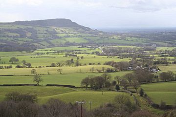
The Cloud, also known as Bosley Cloud, is a well-known hill located right on the border between Cheshire and Staffordshire in England. It's just a couple of miles west of the Peak District National Park.
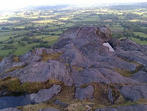
Standing at 343 meters (1,125 feet) high, it's one of the tallest hills in this area. The top of the hill is covered in heather plants. At the very summit, there's a special marker called a trig point. From here, you can see amazing views of nearby towns like Congleton, Biddulph, Macclesfield, Holmes Chapel, and even parts of the Greater Manchester area.
The Cloud is at the northern end of a line of hills that stretch along the border between Cheshire and Staffordshire. To its north, the River Dane flows around its lower slopes. The A523 road runs to its east, passing through the village of Bosley in Southeast Cheshire.
How The Cloud Was Formed
The top and upper parts of The Cloud are made from a type of rock called Chatsworth Grit. This is a thick, coarse sandstone with small pebbles in it. It's part of a larger rock group called Millstone Grit, which formed during the Carboniferous period (a very long time ago!).
The lower parts of the hill are made of mudstone, but you usually can't see these rocks. The shape of The Cloud was also affected by huge sheets of ice during past ice ages. These glaciers moved around the sides of the hill, shaping it over thousands of years.
Exploring The Cloud
The top of The Cloud and the land around it are owned by the National Trust. This means people have been able to visit and explore the hill for many years. A law called the Countryside and Rights of Way Act 2000 also helps make sure people can access places like this.
Several public footpaths cross the hill, connecting it to the smaller roads around its base. Two popular walking routes, the Staffordshire Way and the Gritstone Trail, both go up to the summit of The Cloud. They pass through Timbersbrook on their way towards the Dane Valley.
The Double Sunset Phenomenon
The "double sunset" is a special event that people in the local area celebrate. It's an amazing natural show that used to be seen from the churchyard of Saint Edward the Confessor in Leek. This happened on the summer solstice, which is the longest day of the year.
Here's how it works:
- First, the sun appears to set on the very top of The Cloud.
- Then, it briefly reappears from behind the hill's steep northern side.
- Soon after, it sets for a second and final time on the horizon.
The first time this was written down was in 1686 by Robert Plot in his book The Natural History Of Stafford-shire. However, people likely watched this spectacle for many centuries before that.
Today, you can't see the double sunset from the traditional churchyard spot because trees have grown too tall. But you can still witness it on the summer solstice from other places in Leek. These include Lowe Hill, on the edge of town, and from the road to Pickwood Hall, off Milltown Way. Even better places to see it are from the A523 above Rudyard Lake and from Woodhouse Green. These events and their locations are explained in detail in Jeff Kent's book The Mysterious Double Sunset.
 | Misty Copeland |
 | Raven Wilkinson |
 | Debra Austin |
 | Aesha Ash |


