
Tiburon, California facts for kids
Quick facts for kids
Tiburon, California
|
|
|---|---|
| Town of Tiburon | |

View of Downtown Tiburon near the Ferry Docks
|
|

Location in Marin County and the state of California
|
|

Tiburon, California
Location in San Francisco Bay Area

Tiburon, California
Location in California

Tiburon, California
Location in the United States
|
|
| Country | United States |
| State | California |
| County | Marin |
| Incorporated | June 23, 1964 |
| Area | |
| • Total | 13.22 sq mi (34.23 km2) |
| • Land | 4.48 sq mi (11.60 km2) |
| • Water | 8.74 sq mi (22.63 km2) 66.27% |
| Elevation | 13 ft (4 m) |
| Population
(2020)
|
|
| • Total | 9,146 |
| • Density | 2,027.6/sq mi (782.85/km2) |
| Time zone | UTC-8 (Pacific) |
| • Summer (DST) | UTC-7 (PDT) |
| ZIP Code |
94920
|
| Area codes | 415/628 |
| FIPS code | 06-78666 |
| GNIS feature IDs | 1659998, 2413389 |
Tiburon is a town in Marin County, California. It sits on the Tiburon Peninsula, which reaches south into the San Francisco Bay. The town shares a ZIP code (94920) with Belvedere, a smaller city next to it. Tiburon is surrounded by the bay on most sides. It borders Corte Madera to the north and Mill Valley to the west.
The population of Tiburon was 9,146 people in 2020. About 6,600 people living there are registered to vote. Tiburon and Belvedere share a post office, a library, and a recreation center.
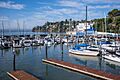
The name "Tiburon" comes from the Spanish word for "shark". This name was given to the peninsula because many leopard sharks were seen in the waters nearby. Tiburon used to be a major train station where goods were moved onto barges to be shipped around San Francisco Bay. Today, it is a town where people live and travel to work in other cities. It is also a popular place for tourists. You can take fast ferries from Tiburon to San Francisco. The town has many restaurants and shops. It is also the closest place on the mainland to Angel Island, and ferries go there regularly.
Contents
Exploring Tiburon's Past
Native Americans lived in the Tiburon area a long time ago. They left behind interesting rock carvings on Ring Mountain.
The first post office in Tiburon opened in 1884. The town officially became an incorporated city in 1964.
Early Days: 1775–1882
The name Tiburón means "shark" in Spanish. In 1775, a Spanish explorer named Lt. Juan Manuel de Ayala anchored his ship near what is now Angel Island. He named the land Punta del Tiburón, or Shark Point. No one knows for sure if he saw sharks or if the peninsula looked like a shark. The Coast Miwok Native Americans lived here for thousands of years before that.
John Reed received a large land grant from the Mexican government in 1831. This land included the Tiburon Peninsula. He officially received the Rancho Corte Madera del Presidio in 1834. John Reed married Hilaria Sánchez in 1836. You can still find streets and neighborhoods named after the Reed family today.
Hilaria's granddaughter, Hilarita Reed, married Dr. Benjamin Lyford. He was one of the first people to develop land here. His project was called Lyford's Hygeia, which is now known as Old Tiburon. The Benjamin and Hilarita Lyford House was once part of their dairy farm. Today, it is part of the Audubon Society's Western Headquarters.
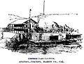
The Industrial Era and Railroads

-L1003487.jpg)

Life in Tiburon changed a lot when Peter Donahue arrived in 1882. He brought the San Francisco and North Pacific Railroad to the area. Donahue worked with the Reed family to build a railroad terminal. This terminal connected trains with ferries of San Francisco Bay. Passenger ferries took people and cars to San Francisco. Barges carried train cars full of goods to other cities.
Old St. Hilary's is a famous landmark in Tiburon. It was built in 1888 as a church for railroad workers. Later, it was saved from being torn down by people who wanted to protect local history. Today, it is a popular place for weddings and concerts.
The last train-operated passenger ferry left Tiburon in 1941. However, passenger and freight trains continued to run until 1967. In the 1960s, ferry service for people started again. The railroad tracks were removed in the 1970s. The old railroad path is now a waterfront rail trail used by walkers and cyclists. The former railroad yards were developed into the Point Tiburon housing and business area.
The railroad and ferry service brought many other businesses to Tiburon. There were canneries that processed fish from Alaska. Companies also broke apart old ships. In 1904, the Navy built a large coaling station to refuel ships. Brick factories and powder plants also opened.
Some of the biggest San Francisco Bay ferries were built in Tiburon. The Navy coaling station was very important. Theodore Roosevelt's Great White Fleet refueled there during its famous trip around the world. The coaling station closed in 1931. The California Maritime Academy then used the site to train officers for merchant ships.
Tiburon During World War II
As World War II approached, the coaling station became the United States Navy Net Depot Tiburon. This place made and repaired large nets. These nets were used to stop enemy torpedoes and submarines from entering San Francisco Bay. Later, research centers for mining and fishing were built there. The Coast Guard also used it as a summer base for their icebreakers. Today, it is the Romberg Tiburon Center for Environmental Studies for San Francisco State University.
During this time, Tiburon was a busy place with sailors, railroad workers, and cannery employees. Main Street was a popular spot on Saturday nights. The Corinthian Yacht Club also had many activities.
After World War II, Tiburon began to grow. New housing areas like Bel Aire and Belveron Gardens were built. The county started making a plan for the Tiburon Peninsula. This plan included ideas for new roads and more housing.
Becoming a City and Growing

People had tried to make Tiburon an official city many times before. But these attempts failed because large landowners did not agree. In 1963, community leaders decided to try again. They wanted to change the old development plan, improve police services, and protect open spaces. They also wanted a local government that listened to them.
One of the first decisions was what areas to include in the new city. They decided to include Angel Island within the city limits. In March 1964, people voted to create the Town of Tiburon. On June 23, 1964, Tiburon officially became a town. A town council was chosen, and a mayor was elected.
The new town council hired a city manager and set up a Planning Commission. They created a new master plan for the peninsula. They also made new rules to protect trees and views. The town bought hundreds of acres of open space to preserve it. The Nature Conservancy also bought land to protect the ridgelines. The town bought the old railroad path, which became a rail trail along Richardson Bay.
Traffic planning was a big decision. It was decided that Tiburon Boulevard would mostly remain a two-lane road. A four-lane bypass section was completed in 1966. This bypass helped improve traffic flow. The land from this project became McKegney Green and the park south of Knoll Park. Blackie's Pasture also became part of the waterfront parks.
Tiburon continued to grow westward. Areas like Reedland Woods and Bel Aire were added to the city.
Tiburon After 1997
.jpg)

In 1985, the Point Tiburon development was finished in the old railroad yards. This brought new people and needs to the area. A new Town Hall opened in 1997, with a new Belvedere-Tiburon Library next door. A new police station was built in 2000.
After a big Millennium Party, the town decided to improve Main Street and downtown Tiburon. Main Street was rebuilt to make it easier for everyone to use. The Allan Thompson Walkway along the water was also rebuilt. In 2004, "Friday Nights on Main Street" parties started. Main Street was closed to cars, and restaurants set up tables outside. This festival is still popular today.
In 2006, a fountain with a sculpture called "Coming About" was placed at the entrance to Main Street. The sculpture looks like a nautical theme. A local family donated the money for the sculpture.
Development and Growth

New building projects are a big topic in Tiburon. This has been true for over 30 years. Any new building or changes to existing buildings must be approved. This helps keep the town looking nice and protects views for neighbors.
There are still large areas of undeveloped land in Tiburon. Owners of these lands want to build many homes there. Many of these properties are outside the town's official borders. However, if they are developed, Tiburon would need to provide services like water and police. So, the town's planning commission decides how much these lands can be developed.
Major land areas being planned for development include the Martha Property, Easton Point, and Tiburon Glen. The process for getting permission to build is long and often involves disagreements. Developers want to build, but residents want to protect open spaces. They also want to avoid more traffic. The Tiburon Last Chance Committee is very active in opposing development. No building has started on these open lands yet.
The Martha Co. property and Easton Point are especially debated. Court cases about these lands go back to 1975. Ring Mountain was also a contested area. It has many different plants and animals, including rare and endangered species like the mariposa lily.
In 2002, residents voted on a rule that would have stopped much of the development on open lands. It would have banned building near ridgelines. The proposal was narrowly defeated. Some people argued it would lead to expensive lawsuits from developers.
In 2006, there was a disagreement about the expansion plans for the Kol Shofar Synagogue. Neighbors were concerned about the size of a new room and the noise and traffic from more events. The Tiburon Planning Commission rejected the plans. The synagogue argued that stopping their expansion would go against their religious freedom. The town council tried to find a solution. In 2008, a judge ruled in favor of the expansion. The synagogue's new space opened in 2010.
Geography and Weather
Tiburon is located at 37°52′25″N 122°27′24″W / 37.87361°N 122.45667°W.
The town covers about 13.2 square miles (34.2 square kilometers). About 4.4 square miles (11.6 square kilometers) is land. The rest, about 8.7 square miles (22.6 square kilometers), is water, mostly in Richardson Bay.
The unique serpentine soils of Ring Mountain and the Tiburon hills are home to special plants. These include the Tiburon mariposa lily, the Tiburon indian paintbrush, and the Tiburon jewelflower. Many other rare and endangered species also live here. Ring Mountain is also important for Native American history, with its ancient rock carvings.
| Climate data for Tiburon, California | |||||||||||||
|---|---|---|---|---|---|---|---|---|---|---|---|---|---|
| Month | Jan | Feb | Mar | Apr | May | Jun | Jul | Aug | Sep | Oct | Nov | Dec | Year |
| Record high °F (°C) | 79 (26) |
81 (27) |
84 (29) |
94 (34) |
96 (36) |
101 (38) |
103 (39) |
96 (36) |
101 (38) |
102 (39) |
86 (30) |
76 (24) |
103 (39) |
| Mean daily maximum °F (°C) | 55.3 (12.9) |
59.6 (15.3) |
63.0 (17.2) |
66.0 (18.9) |
69.6 (20.9) |
73.8 (23.2) |
76.4 (24.7) |
76.8 (24.9) |
76.8 (24.9) |
72.0 (22.2) |
62.6 (17.0) |
55.4 (13.0) |
67.3 (19.6) |
| Mean daily minimum °F (°C) | 42.9 (6.1) |
44.8 (7.1) |
46.0 (7.8) |
47.5 (8.6) |
50.0 (10.0) |
52.7 (11.5) |
54.0 (12.2) |
54.4 (12.4) |
53.8 (12.1) |
51.4 (10.8) |
47.1 (8.4) |
43.0 (6.1) |
49.0 (9.4) |
| Record low °F (°C) | 30 (−1) |
31 (−1) |
35 (2) |
40 (4) |
44 (7) |
47 (8) |
47 (8) |
48 (9) |
48 (9) |
43 (6) |
39 (4) |
27 (−3) |
27 (−3) |
| Average precipitation inches (mm) | 5.13 (130) |
4.96 (126) |
3.54 (90) |
1.77 (45) |
0.85 (22) |
0.24 (6.1) |
0 (0) |
0 (0) |
0.12 (3.0) |
1.22 (31) |
2.72 (69) |
5.25 (133) |
25.80 (655) |
Population and People
| Historical population | |||
|---|---|---|---|
| Census | Pop. | %± | |
| 1970 | 6,209 | — | |
| 1980 | 6,685 | 7.7% | |
| 1990 | 7,532 | 12.7% | |
| 2000 | 8,666 | 15.1% | |
| 2010 | 8,962 | 3.4% | |
| 2020 | 9,146 | 2.1% | |
| U.S. Decennial Census | |||
<graph>{"version":2,"width":234,"height":192,"data":[{"name":"table","values":[{"x":1970,"y":6209},{"x":1980,"y":6685},{"x":1990,"y":7532},{"x":2000,"y":8666},{"x":2010,"y":8962},{"x":2020,"y":9146}]}],"scales":[{"name":"x","type":"ordinal","range":"width","zero":false,"domain":{"data":"table","field":"x"}},{"name":"y","type":"linear","range":"height","nice":true,"domain":{"data":"table","field":"y"}}],"axes":[{"type":"x","scale":"x"},{"type":"y","scale":"y"}],"marks":[{"type":"rect","from":{"data":"table"},"properties":{"enter":{"x":{"scale":"x","field":"x"},"y":{"scale":"y","field":"y"},"y2":{"scale":"y","value":0},"fill":{"value":"steelblue"},"width":{"scale":"x","band":"true","offset":-1}}}}]}</graph> This graph shows how Tiburon's population has grown since it became a town.
Tiburon's Population in 2010
In 2010, Tiburon had 8,962 people. Most of the people (88.1%) were White. About 5.6% were Asian, and 0.9% were African American. People of Hispanic or Latino background made up 4.6% of the population.
Most people (99.6%) lived in homes. There were 3,729 households. About 31.1% of these households had children under 18. The average household had 2.39 people. The average family had 2.94 people.
The population included 24.0% under 18 years old. About 21.2% were 65 years or older. The average age in Tiburon was 48.0 years.
There were 4,025 housing units. Most homes (67.8%) were owned by the people living in them. The rest (32.2%) were rented.
Tiburon's Population in 2000
In 2000, Tiburon had 8,666 people. There were 3,712 households and 2,409 families. The racial makeup was similar to 2010, with most people being White.
About 21.9% of the population was under 18. About 16.5% were 65 or older. The average age was 45 years.
The median income for a household in Tiburon was $106,611. For a family, it was $149,041. The income per person was $85,966. Only a small number of families (1.6%) and people (3.3%) lived below the poverty line.
Forbes magazine ranked Belvedere/Tiburon as one of the most expensive places to live in the United States for real estate. It was ranked 18th.
Tiburon's Economy


Tiburon has many small shops and restaurants. These businesses serve both local residents and tourists. Most of the town's restaurants are on or near Main Street, close to the Tiburon Ferry Terminal. You can take a ferry from here to the San Francisco Ferry Building or to nearby Angel Island.
In 2004, Tiburon made history by becoming the first city in the world to remove trans-fats from all its restaurants.
There is a small shopping center called The Boardwalk downtown. Another shopping center, The Cove, is in the Bel Aire neighborhood.
A weekly newspaper called The Ark has been published in Tiburon since 1973. It covers local news and events. This newspaper has won many awards for its quality.
Education in Tiburon
Schools in Tiburon
Tiburon, Belvedere, and part of Corte Madera are in the Reed Union School District. This district has three schools, all located in Tiburon:
- Reed Elementary for grades K–2
- Bel Aire Elementary for grades 3–5
- Del Mar Middle School for grades 6–8
All three of these public schools have been recognized as "California Distinguished Schools." St. Hilary School is a Catholic primary school for grades K–8. It is also in Tiburon and serves students from many nearby communities. St. Hilary School is an "Apple Distinguished School."
All three of Tiburon's public schools have been rebuilt or are being rebuilt. Reed Elementary finished its reconstruction in 2004. Both Bel Aire and Del Mar finished their reconstruction in 2006.
Students from Tiburon attend Redwood High School in Larkspur.
Public Libraries
The Belvedere-Tiburon Library is located in Tiburon. It was started in 1895. The library moved several times before settling in its current building in 1997. The library completed a large expansion project in 2022. It is now 19,117 square feet in size.
Natural Hazards and Safety
In 2006, Tiburon started the Get Ready 94920 program. This program aims to train all citizens in disaster preparedness. In 2011, a tsunami from Japan caused waves as high as 7 feet (2.1 meters) in Richardson Bay.
Notable People from Tiburon
Many interesting people have lived in Tiburon:
- John W. Bowen (1910–1977), a U.S. Army lieutenant general.
- Businesswoman Jan Brandt owns a home here.
- Actor Clint Eastwood (born 1930) and actress Sondra Locke (1944–2018) lived here in the 1970s.
- Geneticist Charles Epstein (1933–2011) passed away in Tiburon.
- Actor Paul Frees (1920–1986) lived here until his death.
- Radio host Michael Savage (born 1942) lives in Tiburon.
- Film director Henry Selick (born 1952) lives in Tiburon.
- Screenwriter Stirling Silliphant (1918–1996) lived here until 1988.
- Musician Lars Ulrich, the drummer for Metallica, (born 1963) lived here for a time.
- Actor Robin Williams (1951–2014) lived here when he was young and moved back later in life.
- Former San Francisco Giants baseball player Barry Bonds (born 1964) lives in Tiburon.
- Skier Jonny Moseley (born 1975) has lived here since 1978.
- Novelist Isabel Allende (born 1942) lives in Tiburon.
- Actress Shoshana Bush (born 1988) is from Tiburon.
- NBA Star Klay Thompson (born 1990) lived in Tiburon for a period.
Images for kids
-
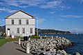
Corinthian Yacht Club House c. 1894 in Tiburon
-
Corinthian Yacht Club in July 2023
-
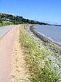
The former railroad grade now forms part of the San Francisco Bay Trail, used by hikers and cyclists.
-
A rail trail passes through Richardson Bay Park and next to the Audubon Society's Richardson Bay Sanctuary within Tiburon town limits.
-
Tiburon Railroad & Ferry Depot Museum
-
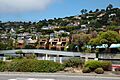
A modern development on Tiburon Boulevard, with the residential neighborhood Hill Haven in the background.
-
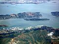
Aerial view of the Tiburon Peninsula
-
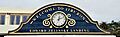
Welcome to Tiburon sign
-
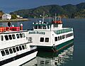
Tiburon is the nearest mainland point to Angel Island and a regular ferry service from the Tiburon Ferry Terminal connects to the island.
See also
 In Spanish: Tiburón (California) para niños
