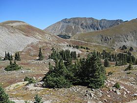
Tomichi Pass facts for kids
Quick facts for kids Tomichi Pass |
|
|---|---|

Tomichi Pass
|
|
| Elevation | 11,962 ft (3,646 m) |
| Traversed by | Forest Road 888 |
| Location | Gunnison County, Colorado, U.S. |
| Range | Sawatch Range |
| Coordinates | 38°36′13″N 106°23′00″W / 38.6036070°N 106.3833589°W |
| Topo map | Whitepine |
Tomichi Pass is a high mountain pass located in the Sawatch Range of the Rocky Mountains in Colorado. It sits high up in Gunnison County, within the Gunnison National Forest. This pass is like a natural dividing line. It separates the streams that flow into Middle Quartz Creek to the north from those that flow into Tomichi Creek to the south. The pass reaches an elevation of about 11,962 feet (3,646 meters) above sea level.
You can travel over Tomichi Pass using Forest Road 888. This road is mainly for vehicles with four-wheel drive. It can be quite narrow and open, especially when you are on the north side.
Exploring Tomichi Pass
Tomichi Pass has a long history. In the 1870s, it was first used as a path for pack animals. These animals carried supplies between mining towns and camps. These camps were located both north and south of the pass. Over time, the path was improved. It eventually became wide enough for wagons to pass through. However, the road never became a very busy route.
How Tomichi Pass Formed
Tomichi Pass is part of a ridge made of a type of rock called intrusive rock. This rock formed deep underground a long time ago. It pushed its way into older rocks, including granite and sedimentary rock. Many smaller rock formations, like dikes and sills, also formed here.
In the 1800s, miners came to this area. They were looking for valuable metals like gold, silver, and lead. These metals were often found along these rock intrusions. You can still see signs of old mining activity on both sides of the pass.
Some rocks on the ridge to the east of the pass are called ash flow tuffs. These rocks came from volcanoes far away. They were formed by volcanic eruptions in the San Juan volcanic field to the southwest. These eruptions happened around 23 to 34 million years ago. This was about the same time the granitic rocks were forming underground.
Over millions of years, erosion has worn away much of the tuff. This process has revealed the intrusive rock that makes up the pass today. Pleistocene glaciers also helped shape the area. They carved out the valleys on both sides of the pass. As they melted, they left behind piles of rock and dirt called moraines.
 | James Van Der Zee |
 | Alma Thomas |
 | Ellis Wilson |
 | Margaret Taylor-Burroughs |

