Tompkinsville, Kentucky facts for kids
Quick facts for kids
Tompkinsville, Kentucky
|
|
|---|---|

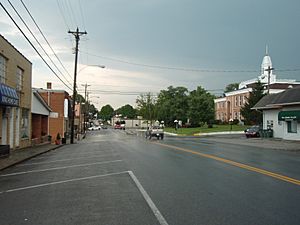
Downtown Tompkinsville
|
|

Location in Monroe County, Kentucky
|
|
| Country | United States |
| State | Kentucky |
| County | Monroe |
| Area | |
| • Total | 3.45 sq mi (8.94 km2) |
| • Land | 3.28 sq mi (8.51 km2) |
| • Water | 0.17 sq mi (0.44 km2) |
| Elevation | 919 ft (280 m) |
| Population
(2020)
|
|
| • Total | 2,309 |
| • Estimate
(2022)
|
2,297 |
| • Density | 703.11/sq mi (271.44/km2) |
| Time zone | UTC-6 (Central (CST)) |
| • Summer (DST) | UTC-5 (CDT) |
| ZIP code |
42167
|
| Area code(s) | 270 & 364 |
| FIPS code | 21-77160 |
| GNIS feature ID | 0505341 |
Tompkinsville is a small city in Kentucky, United States. It is the main town and county seat of Monroe County. In 2020, about 2,309 people lived there. The city was named after Daniel D. Tompkins, who was a Vice President. The county itself was named after James Monroe, a President.
Contents
History of Tompkinsville
Early Beginnings and Important Sites
In 1804, a special building called the Old Mulkey Meetinghouse was built. Today, it is a state historic site. There is a graveyard there where soldiers from the American Revolutionary War and the American Civil War are buried. Daniel Boone's sister, Hannah, is also buried at this historic spot.
Tompkinsville During the Civil War
During the American Civil War, Tompkinsville was attacked by Confederate General John Hunt Morgan. This was his first raid into Kentucky. On July 9, 1862, Morgan's soldiers came from Tennessee. They attacked a group of Union soldiers.
Morgan's raiders captured 30 Union soldiers. They also destroyed tents and supplies. They took 20 wagons, 50 mules, 40 horses, and supplies like sugar and coffee. After this, they went to Glasgow, Kentucky, burned more supplies, and raided 16 other towns before going back to Tennessee.
Local Traditions and Changes
Tompkinsville is famous for Dovie's restaurant. This restaurant has been known for its unique deep-fried hamburgers since 1938.
In 2023, a vote made it legal to sell alcohol in Tompkinsville and all of Monroe County. Before this, the city was considered a "dry" area, meaning alcohol sales were not allowed.
Geography of Tompkinsville
Where Tompkinsville Is Located
Tompkinsville is located in the middle of Monroe County. Its exact location is 36°41′58″N 85°41′31″W / 36.69944°N 85.69194°W. Two main roads, Kentucky Route 63 and Kentucky Route 100, go through the city. They are together on South Main Street.
KY 63 then turns onto West 4th Street. KY 100 turns onto North Magnolia Street. KY 63 goes northwest about 26 miles to Glasgow. KY 100 goes northeast about 22 miles to Waterview. Both highways together go southwest about 8 miles to Gamaliel. Another road, Kentucky Route 163, leaves Tompkinsville to the north. It goes about 21 miles to Edmonton.
Land and Water Around the City
Tompkinsville covers a total area of about 3.45 square miles. Most of this area, about 3.28 square miles, is land. The rest, about 0.17 square miles, is water.
Town Creek flows through the city, just east of its center. It flows southwest to Mill Creek at the city's southern edge. Mill Creek then flows west into the East Fork of the Barren River. The Barren River is part of the Green River system.
Population of Tompkinsville
| Historical population | |||
|---|---|---|---|
| Census | Pop. | %± | |
| 1830 | 218 | — | |
| 1840 | 188 | −13.8% | |
| 1870 | 218 | — | |
| 1880 | 248 | 13.8% | |
| 1900 | 366 | — | |
| 1910 | 639 | 74.6% | |
| 1920 | 721 | 12.8% | |
| 1930 | 850 | 17.9% | |
| 1940 | 1,438 | 69.2% | |
| 1950 | 1,859 | 29.3% | |
| 1960 | 2,091 | 12.5% | |
| 1970 | 2,207 | 5.5% | |
| 1980 | 3,077 | 39.4% | |
| 1990 | 2,861 | −7.0% | |
| 2000 | 2,660 | −7.0% | |
| 2010 | 2,402 | −9.7% | |
| 2020 | 2,309 | −3.9% | |
| 2022 (est.) | 2,297 | −4.4% | |
| U.S. Decennial Census | |||
In 2000, there were 2,660 people living in Tompkinsville. There were 1,169 households, which are groups of people living together. About 702 of these were families.
Most people in the city were White (89.47%). About 8.95% were African American. A small number of people were from other backgrounds. About 1.09% of the population was Hispanic or Latino.
About 21.9% of the people were under 18 years old. The average age in the city was 41 years. For every 100 females, there were about 76 males.
Education
Tompkinsville has a public library called the William B. Harlan Memorial Library. It is a place where people can read books and learn.
Notable People from Tompkinsville
Many interesting people have come from Tompkinsville:
- Tim Lee Carter: He was a U.S. representative for Kentucky. This means he helped make laws for the country.
- James Comer: He was the Kentucky Commissioner of Agriculture. He is now also a U.S. representative.
- Joe H. Eagle: He was a U.S. representative for Texas.
- Tom Emberton: He was a politician and a judge.
- Elois Grooms: He was a defensive lineman in the National Football League, a professional football league.
- Eagle Keys: He was a football coach and player in Canadian football.
- Samuel B. Maxey: He was a major general for the Confederacy during the Civil War. Later, he represented Texas in the U.S. Senate.
- Shawn McPherson: He is a member of the Kentucky House of Representatives.
- Pearl Carter Pace: She was the first woman sheriff in Kentucky. A sheriff is a top law enforcement officer in a county.
See also
 In Spanish: Tompkinsville (Kentucky) para niños
 | Shirley Ann Jackson |
 | Garett Morgan |
 | J. Ernest Wilkins Jr. |
 | Elijah McCoy |


