
Toutle River facts for kids
Quick facts for kids Toutle River |
|
|---|---|

Mouth of the river in flood near Castle Rock before the 1980 eruption of Mount St. Helens
|
|

Location of the mouth of Toutle River in Washington
|
|
| Country | United States |
| State | Washington |
| County | Cowlitz |
| Physical characteristics | |
| Main source | Confluence of North and South forks near Toutle 440 ft (130 m) 46°19′40″N 122°43′03″W / 46.32778°N 122.71750°W |
| River mouth | Cowlitz River near Castle Rock 46 ft (14 m) 46°18′39″N 122°55′06″W / 46.31083°N 122.91833°W |
| Length | 17.2 mi (27.7 km) |
| Basin features | |
| Basin size | 511 sq mi (1,320 km2) |
The Toutle River is a river in Washington, USA. It is about 17 miles (28 km) long. This river flows into the Cowlitz River.
The Toutle River starts from two smaller rivers, called the North Fork and South Fork. These two parts join together near the town of Toutle. The river then flows into the Cowlitz River near Castle Rock. This is about 20 miles (32 km) upstream from where the Cowlitz River meets the Columbia River.
The Toutle River changed a lot after the 1980 eruption of Mount St. Helens. The volcano sent huge amounts of ash and mud into the river. To help manage this, people dug out mud and sand (called sediment). They also built a special dam called the Toutle River Sediment Retention Structure on the North Fork Toutle River.
Contents
Journey of the Toutle River
The Toutle River begins where its two main branches, the North Fork Toutle River and the South Fork Toutle River, meet. This meeting point is close to the community of Toutle. Both branches start on Mount St. Helens inside the Mount St. Helens National Volcanic Monument.
From their start, the branches generally flow west. They then combine to form the main Toutle River. The main river also flows mostly west, but it sometimes turns north or south. The town of Toutle is on the left side of the river, about 17 miles (27 km) from where the river ends.
River's Path and Surroundings
At first, the Toutle River flows north for about 1 mile (1.6 km). It runs along the base of Beigle Mountain, which is on its right side. The river keeps going north until it reaches about 13 miles (21 km) from its end. Here, it makes a big turn to the southwest.
For the next few miles, Tower Road runs along the right side of the river. About 10 miles (16 km) from the end, Tower Cemetery is also on the right. After the cemetery, the river flows through a place called Hollywood Gorge. Here, Rock Creek joins the Toutle River from the right. The river continues southwest. About 7 miles (11 km) from its end, Stankey Creek flows into it from the left.
The Toutle River then turns west. It goes under Tower Road again. Cline Creek joins the river from the right. Further along, Burma Road is on the right side of the river. For its last 4 miles (6.4 km), the Toutle River winds southwest. It flows through large areas of sand that have been deposited there. The river passes under Barnes Drive and then under Interstate 5. Finally, it enters the Cowlitz River. This is about 2 miles (3.2 km) upstream from the city of Castle Rock. After this, the Cowlitz River flows for another 20 miles (32 km). It then joins the Columbia River, which is about 68 miles (109 km) from the Pacific Ocean.
How Much Water Flows?
The United States Geological Survey (USGS) measures how much water flows in the Toutle River. They have a special station about 6.5 miles (10.5 km) from the river's end. On average, the river flows at about 2,095 cubic feet per second (59.3 m³/s).
This measurement comes from an area of 416 square miles (1,077 km²). This is about 81 percent of the total area that drains into the Toutle River. The most water ever recorded flowing there was 61,800 cubic feet per second (1,750 m³/s). This happened on February 8, 1996. The least amount of water recorded was 243 cubic feet per second (6.9 m³/s) on October 14, 1987. These records cover 30 years, starting in 1981, after the volcano erupted.
Before these records, there were two very large floods on May 18, 1980. These floods were caused by volcanic mudflows. The mudflows came down the South Fork and then the North Fork, about nine hours apart.
Volcano's Impact on the River
The 1980 eruption of Mount St. Helens caused huge amounts of sediment (like mud, ash, and rocks) to pour into the Toutle River. This happened because of large mudflows, called lahars, that came down the volcano.
The United States Army Corps of Engineers worked to clean up the river. They dug out a lot of the sediment. They also built a large structure called the Toutle River Sediment Retention Structure. This $65 million project is on the North Fork Toutle River. Its purpose is to stop more debris from flowing downstream into other rivers.
As part of this big engineering project, a tunnel was also built. This tunnel helps to drain Spirit Lake. Spirit Lake is on the north side of the volcano. After the eruption, the lake's natural way of draining was blocked, so the tunnel was needed.
Images for kids
-
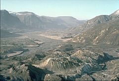
The North Fork Toutle River valley in 1983. It was filled with debris and hills from the Mount St. Helens landslide.
-
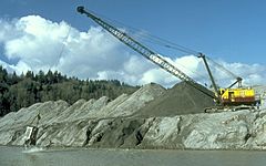
Workers dredging (digging out) volcanic ash from the Toutle River.
-
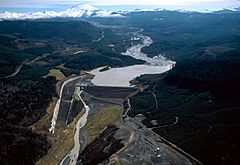
The Sediment Retention Structure on the North Fork Toutle River.


