
Trois-Rivières facts for kids
Quick facts for kids
Trois-Rivières
|
|||||
|---|---|---|---|---|---|
| Ville de Trois-Rivières | |||||

From top, left to right: Downtown Trois-Rivières from the St. Lawrence River, monument to Sacré-Coeur, Trois-Rivières Cathedral, Laviolette Bridge, Pacifique Du Plessis gate, Ursulines monastery
|
|||||
|
|||||
| Motto(s):
Deus nobiscum quis contra
("If God is with us, who can be against us") |
|||||

Trois-Rivières metropolitan area
|
|||||

Trois-Rivières
Location in Quebec

Trois-Rivières
Location in Canada
|
|||||
| Country | Canada | ||||
| Province | Quebec | ||||
| Region | Mauricie | ||||
| RCM | None | ||||
| Founded | July 4, 1634 by Laviolette | ||||
| Incorporated | June 10, 1857 | ||||
| Constituted | January 1, 2002 | ||||
| Boroughs | Cap-de-la-Madeleine, Trois-Rivières-Ouest, Saint-Louis-de-France, Pointe-du-Lac, Sainte-Marthe-du-Cap |
||||
| Government | |||||
| • Type | Trois-Rivières City Council | ||||
| Area
(2021)
|
|||||
| • Land | 288.65 km2 (111.45 sq mi) | ||||
| • Urban | 98.58 km2 (38.06 sq mi) | ||||
| • Metro | 1,038.64 km2 (401.02 sq mi) | ||||
| Elevation | 61 m (200 ft) | ||||
| Population
(2021)
|
|||||
| • City | 139,163 | ||||
| • Density | 482.1/km2 (1,249/sq mi) | ||||
| • Urban | 128,057 | ||||
| • Urban density | 1,299.0/km2 (3,364/sq mi) | ||||
| • Metro | 161,489 | ||||
| • Metro density | 155.5/km2 (403/sq mi) | ||||
| • Pop 2016-2021 | |||||
| • Dwellings | 70,411 | ||||
| Demonym(s) | Trifluvians | ||||
| Time zone | UTC−05:00 (EST) | ||||
| • Summer (DST) | UTC−04:00 (EDT) | ||||
| Postal code(s) |
G8T to G8Z, G9A to G9C
|
||||
| Area code | 819 | ||||
| GDP (Trois-Rivières CMA) | CA$6.3 billion (2016) | ||||
| GDP per capita (Trois-Rivières CMA) | CA$40,290 (2016) | ||||


Trois-Rivières is a city in Quebec, Canada. It sits where the Saint-Maurice and Saint Lawrence rivers meet. This city is on the north side of the Saint Lawrence River, right across from Bécancour. It's located about halfway between Montreal and Quebec City. Trois-Rivières is a very important place for business and culture in its region, called Mauricie. French settlers founded it on July 4, 1634. It was the second permanent settlement in New France, after Quebec City.
The name Trois-Rivières means "Three Rivers" in French. It got this name because the Saint-Maurice River splits into three channels where it flows into the Saint Lawrence. This happens because of two islands, Potherie (Île Caron) and Île Saint-Quentin. The famous explorer Jacques Cartier visited this area in 1535. He even planted a cross on Saint-Quentin Island.
Contents
What's in a Name?
The city's name, Trois-Rivières, means 'three rivers' in French. It refers to how the Saint-Maurice River divides into three parts as it joins the Saint Lawrence River. Two islands in the river create these three channels.
The name Trois-Rivières was first used in 1599 by Sieur François Gravé Du Pont. He was a geographer working with Champlain. His records from 1603 confirmed the name. As he sailed upriver, he thought he saw three separate rivers. He didn't know that two large islands split the Saint-Maurice River into three sections right where it flows into the St. Lawrence.
Historically, in English, this city was called Three Rivers. Today, most people, both English and French speakers, call it Trois-Rivières. You might still see the old English name in some places, like the city's Three Rivers Academy. People who live in Trois-Rivières are called Trifluviens (Trifluvians).
A Look at History
For thousands of years, Indigenous peoples visited the area of Trois-Rivières. The Algonquin and Abenaki used it as a summer spot. They would fish, hunt, and gather food here. The French explorer Jacques Cartier described the site in 1535 during his second trip to the New World.
The name "Trois-Rivières" was given in 1599 by Captain Dupont-Gravé. It first appeared on maps in 1601.
In 1603, Samuel de Champlain suggested building a permanent settlement here. The village officially started on July 4, 1634. Its first governor was Sieur de Laviolette. This city was the second one founded in New France, after Quebec City. It was very important for the colony and for trading furs with First Nations peoples.
Ursuline nuns arrived in 1697. They started the first school and helped missionaries teach local Indigenous people.
French control of Trois-Rivières lasted until 1760. Then, the British took the city during the Seven Years' War. Later, on June 8, 1776, the Battle of Trois-Rivières happened here. This was part of the American Revolutionary War. American soldiers tried to weaken the British settlement.
Trois-Rivières continued to grow. In 1792, it became a judicial district. In 1852, it became the seat of the Roman Catholic Diocese of Trois-Rivières.
In 1908, a big fire destroyed most of Trois-Rivières. Many old buildings from the French colonial years were lost. The Ursuline Monastery and the De Tonnancour Manor were among the few buildings that survived. After the fire, the city was rebuilt with wider roads. Many new businesses and industries came, bringing more people to live there.
In the mid-1900s, the city became very industrial. In the 1960s, Trois-Rivières started to focus on different types of businesses. It also created new cultural places. The Old City of Trois-Rivières was named an "historic sector" in 1964. The Laviolette Bridge, which connects Trois-Rivières to Bécancour, opened on December 20, 1967. In 1969, the city founded the Université du Québec à Trois-Rivières. This university is known for its chiropractic and podiatric medical programs.
Today, Trois-Rivières is one of Quebec's main medium-sized cities. It is still an important place, though not as large as Montreal or Quebec City.
City Geography
Islands of Trois-Rivières
Saint-Quentin Island is where the Saint-Maurice River meets the St. Lawrence River. This is where Trois-Rivières grew. Along with the islands Saint-Christophe and De La Poterie, it creates three channels at the mouth of the Saint-Maurice River. The island was named after Quentin Moral, an early fur trader. Today, it's a popular spot for outdoor fun and relaxing.
Algonquin tribes first lived on the island. They grew corn in the lowlands. On October 7, 1535, Jacques Cartier planted a cross on the island. He claimed the land for France. A special iron cross now marks this spot. The island's natural environment has stayed mostly the same. For almost a century, it was not developed.
Since 1930, Saint-Quentin Island has become a key place for recreation. The city bought the island in 1947. During World War II, it was a training camp for the Royal Canadian Navy. The park and beach on the island opened on June 24, 1962. Many facilities have been added since then. These include a marina, a bike path, an interpretative trail, an ice rink, and camping grounds. Many events and festivals happen on the island every year.
What's the Weather Like?
Trois-Rivières has a humid continental climate. This means it has four distinct seasons. Winters are long, cold, and snowy. In January, the average high is -5.6°C. Temperatures can drop to -20°C on many nights. Snowfall averages 274.4 cm, and snow usually covers the ground from December to March.
Summers are warm. In July, the average high is 25.1°C. Temperatures can reach 30°C on several days each summer. Spring and autumn are short and cool. The city gets about 1001.7 mm of rain and snow each year, with most precipitation in the summer.
The hottest temperature ever recorded was 37.8°C on July 17, 1953. The coldest was -41.7°C on February 5, 1923.
| Climate data for Trois-Rivières (Aqueduc) Climate ID: 701HE63; coordinates 46°23′N 73°37′W / 46.383°N 73.617°W; elevation: 54.9 m (180 ft); 1981−2010 normals, extremes 1920−present |
|||||||||||||
|---|---|---|---|---|---|---|---|---|---|---|---|---|---|
| Month | Jan | Feb | Mar | Apr | May | Jun | Jul | Aug | Sep | Oct | Nov | Dec | Year |
| Record high °C (°F) | 13.0 (55.4) |
11.1 (52.0) |
20.0 (68.0) |
31.5 (88.7) |
33.3 (91.9) |
34.5 (94.1) |
37.8 (100.0) |
36.1 (97.0) |
32.5 (90.5) |
28.9 (84.0) |
22.2 (72.0) |
14.6 (58.3) |
37.8 (100.0) |
| Mean daily maximum °C (°F) | −7.1 (19.2) |
−4.4 (24.1) |
1.4 (34.5) |
9.9 (49.8) |
18.2 (64.8) |
23.3 (73.9) |
25.5 (77.9) |
24.4 (75.9) |
19.4 (66.9) |
11.9 (53.4) |
4.1 (39.4) |
−3.1 (26.4) |
10.3 (50.5) |
| Daily mean °C (°F) | −12.1 (10.2) |
−9.7 (14.5) |
−3.6 (25.5) |
4.8 (40.6) |
12.3 (54.1) |
17.6 (63.7) |
20.0 (68.0) |
18.9 (66.0) |
14.2 (57.6) |
7.4 (45.3) |
0.5 (32.9) |
−7.4 (18.7) |
5.2 (41.4) |
| Mean daily minimum °C (°F) | −17.1 (1.2) |
−14.9 (5.2) |
−8.6 (16.5) |
−0.3 (31.5) |
6.3 (43.3) |
11.8 (53.2) |
14.4 (57.9) |
13.4 (56.1) |
8.9 (48.0) |
2.8 (37.0) |
−3.1 (26.4) |
−11.6 (11.1) |
0.2 (32.4) |
| Record low °C (°F) | −41.1 (−42.0) |
−41.7 (−43.1) |
−35.0 (−31.0) |
−20.0 (−4.0) |
−7.8 (18.0) |
−1.5 (29.3) |
3.5 (38.3) |
0.0 (32.0) |
−7.2 (19.0) |
−11.7 (10.9) |
−27.2 (−17.0) |
−35.6 (−32.1) |
−41.7 (−43.1) |
| Average precipitation mm (inches) | 82.9 (3.26) |
68.8 (2.71) |
75.6 (2.98) |
79.2 (3.12) |
96.3 (3.79) |
107.0 (4.21) |
116.8 (4.60) |
101.3 (3.99) |
100.6 (3.96) |
98.4 (3.87) |
102.4 (4.03) |
93.4 (3.68) |
1,122.8 (44.20) |
| Average rainfall mm (inches) | 24.5 (0.96) |
19.5 (0.77) |
32.0 (1.26) |
66.8 (2.63) |
96.3 (3.79) |
107.0 (4.21) |
116.8 (4.60) |
101.3 (3.99) |
100.6 (3.96) |
95.7 (3.77) |
75.4 (2.97) |
28.1 (1.11) |
863.9 (34.01) |
| Average snowfall cm (inches) | 58.5 (23.0) |
49.3 (19.4) |
43.6 (17.2) |
12.5 (4.9) |
0.0 (0.0) |
0.0 (0.0) |
0.0 (0.0) |
0.0 (0.0) |
0.0 (0.0) |
2.8 (1.1) |
27.1 (10.7) |
65.3 (25.7) |
259.0 (102.0) |
| Average precipitation days (≥ 0.2 mm) | 13.9 | 11.9 | 11.1 | 11.9 | 14.4 | 14.4 | 15.0 | 12.8 | 12.8 | 14.3 | 14.4 | 14.2 | 161.1 |
| Average rainy days (≥ 0.2 mm) | 2.9 | 2.6 | 5.4 | 10.5 | 14.4 | 14.4 | 15.0 | 12.8 | 12.8 | 14.2 | 10.4 | 4.0 | 119.5 |
| Average snowy days (≥ 0.2 cm) | 12.3 | 10.3 | 7.0 | 2.7 | 0.07 | 0.0 | 0.0 | 0.0 | 0.0 | 0.65 | 5.6 | 11.5 | 50.2 |
| Mean monthly sunshine hours | 84.5 | 110.4 | 157.3 | 166.9 | 208.7 | 220.9 | 257.9 | 205.3 | 158.2 | 121.3 | 69.3 | 62.2 | 1,823.1 |
| Percent possible sunshine | 30.1 | 37.9 | 42.7 | 41.1 | 45.0 | 46.9 | 54.1 | 46.8 | 41.9 | 35.8 | 24.4 | 23.1 | 39.1 |
| Source: Environment and Climate Change Canada. Sunshine data recorded at Nicolet | |||||||||||||
Who Lives in Trois-Rivières?

In 2021, Trois-Rivières had a population of 139,163 people. This was a 3.5% increase from 2016. The city has a land area of 288.65 square kilometers. This means about 482 people live in each square kilometer.
The larger Trois-Rivières metropolitan area includes the city and six other towns. In 2021, this area had 161,489 people.
In 2021, the average age in Trois-Rivières was 47.2 years. This is older than the Canadian average of 41.6 years. About 26.3% of the people were 65 or older.
Languages Spoken
French is the main language spoken in Trois-Rivières. For 93.9% of residents, French is their first language. Other languages spoken include English (1.2%), Spanish (1.1%), and Arabic (0.8%).
Religious Beliefs
In 2021, 71.0% of people in Trois-Rivières were Christian. Most of these, 64.6%, were Catholic. About 26.8% of residents said they had no religion. Islam was the largest non-Christian religion, at 1.6%.
Diverse Backgrounds
Most residents of Trois-Rivières are of European background, about 92.1%. About 1.9% are Indigenous peoples. Around 6.0% are from visible minority groups. The largest visible minority groups are Black (2.8%), Latin American (1.2%), and Arab (1.0%).
What is the Economy Like?

Trois-Rivières is Canada's oldest industrial city. Its first iron foundry was built in 1738. This factory made iron and cast metal for 150 years. Much of it was sent to France for navy ships. The first port was built in 1818. Today, it handles 2.5 million tonnes of goods each year. The first railway was built in 1879 to help the growing lumber industry.
From the late 1920s to the early 1960s, Trois-Rivières was known as the world's capital for the pulp and paper industry. The city once had five paper mills. Today, three mills are still working. Many mills closed because people needed less newsprint and because of global changes.
In the 1980s and 1990s, many factories closed, especially textile mills. This led to higher unemployment. Now, Trois-Rivières is trying to bring in new types of industries. It is using its location between Montreal and Quebec City, its university, and its port to attract businesses. For example, Marmen Incorporated makes wind turbine towers and employs many people.
Other important industries in the city include metal work, electronics, and cabinet making. An industrial park near the Trois-Rivières Airport is a big center for the aeronautical industry. Growing food crops is also still important to the economy.
Arts and Culture
Trois-Rivières hosts the FestiVoix de Trois-Rivières. This is a 10-day summer music festival that attracts over 300,000 visitors every year. The city also has an international poetry festival called Festival International de la Poésie. Other events include the Festival International Danse Encore and the MetalFest de Trois-Rivières in November. In 2009, Trois-Rivières was named the Cultural Capital of Canada for cities with over 125,000 people.
Trois-Rivières is officially known as the "Poetry Capital of Quebec." You can find many plaques with poetic verses throughout the city center. The International Festival of Poetry happens every year in early October.
What to See and Do
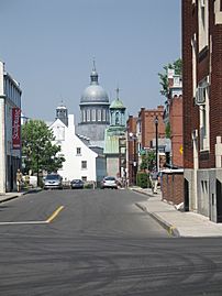
Exploring the City
The main street in Trois-Rivières is Boulevard des Forges. This area in the Old Town has old buildings with cafes, restaurants, clubs, bars, and shops. In warmer months, the street is often closed to cars for festivals. This turns the downtown area into a fun place for people to walk around.
Important landmarks include the Forges du Saint-Maurice, an old iron foundry from the 1730s. The Ursulines Monastery and Notre-Dame-du-Cap Basilica are also famous.
-
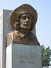
The Sieur de Laviolette, who founded Trois-Rivières. The Laviolette Bridge is named after him.
-
Buildings in old Trois-Rivières.
-
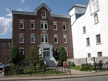
The front of the Ursulines Monastery.


Sports in the City
Trois-Rivières has a famous racetrack called Circuit Trois-Rivières. This track has hosted many important car races.
In baseball, the city has the Trois-Rivières Aigles. They play their home games at Stade Quillorama. For professional ice hockey, the city is home to the ECHL's Trois-Rivières Lions. They are a farm team for the Montreal Canadiens. The city also has the only horse racing track in Quebec, Hippodrome de Trois-Rivières. It hosts live harness racing from May to October.
How to Get Around
Local bus service is provided by the Société de transport de Trois-Rivières. The Laviolette Bridge connects Trois-Rivières to Bécancour on the south side of the Saint Lawrence River. This bridge is the only one across the Saint Lawrence River between Montreal and Quebec City. It is a very important link between the north and south shores. The bridge is known for its impressive design and is a major landmark. About 40,000 vehicles cross it every day. An airport also serves the city.
Passenger train service to Trois-Rivières station stopped in 1990. However, in 2022, Via Rail suggested bringing back passenger train service. This would be part of a new project to connect Toronto, Ottawa, Montréal, and Québec City.
The city also has a major port on the Saint Lawrence River that does not freeze. It handles about 300 ships each year.
Learning and Education
Trois-Rivières is home to the Université du Québec à Trois-Rivières. It also has the Mauricie Campus of the Université de Montréal. This is a special campus for the university's medical school.
Media
Sister Cities
Trois-Rivières has special connections with other cities around the world. These are called "sister cities."
- Châteaudun, France
- Tours, France
Images for kids
-
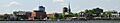
A panoramic view of Trois-Rivières.
-
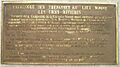
A historical marker honoring Sieur de Laviolette, the founder of Trois-Rivières.

See also
 In Spanish: Trois-Rivières (Quebec) para niños
