
Tropical Depression One (2009) facts for kids
| Tropical depression (SSHWS/NWS) | |

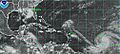
Tropical Depression One on May 28
|
|
| Formed | May 28, 2009 |
|---|---|
| Dissipated | May 29, 2009 |
| Highest winds | 1-minute sustained: 35 mph (55 km/h) Gusts: 45 mph (75 km/h) |
| Lowest pressure | 1006 mbar (hPa); 29.71 inHg |
| Fatalities | None |
| Damage | Minimal |
| Areas affected | Coastal North Carolina |
| Part of the 2009 Atlantic hurricane season | |
Tropical Depression One was the very first tropical cyclone (a type of storm with a spinning center) of the 2009 Atlantic hurricane season. It was also special because it formed before June 1, which is when the Atlantic hurricane season officially begins. This had only happened two times before since 2007.
The storm started on May 28 and moved over the Atlantic Ocean. It didn't last long, though. Later that same day, it began to get weaker and break apart. By May 29, the storm had completely faded away and became what's called a remnant low (just a leftover area of low pressure).
Before it even became a depression, parts of this weather system brought a little bit of rain to the coast of North Carolina. Luckily, there were no reports of damage or anyone getting hurt. The National Hurricane Center (NHC), which tracks storms, didn't even need to issue any special warnings for it.
Contents
How the Storm Formed and Moved

In the middle of May, a messy area of low pressure formed in the Atlantic Ocean. It was about 290 miles (465 kilometers) southwest of Wilmington, North Carolina. This low pressure area started to move north and get a bit more organized.
On May 27, the storm was about 120 miles (195 km) south of Cape Hatteras, North Carolina. That's when the National Hurricane Center (NHC) decided to start watching it closely. A high pressure area to the storm's southeast pushed it towards the northeast. By 8 pm EDT (midnight UTC on May 28), the NHC stopped watching it. They didn't think it would get any stronger.
Becoming a Tropical Depression
But then, on May 28, the NHC started watching the storm again. At 11:00 am EDT (1500 UTC), they officially called it a tropical cyclone and named it Tropical Depression One. At this point, it was about 310 miles (500 km) south of Providence, Rhode Island.
After it was named, the storm showed signs of deep convection (strong thunderstorms). Its center of circulation was on the northwestern side. The depression got stronger because it moved into an area with less wind shear (winds blowing in different directions at different heights, which can tear a storm apart) and warmer ocean waters from the Gulf Stream.
Later that day, the depression started to weaken again. It moved into an area with more wind shear and colder ocean waters. Around 7:30 pm EDT (2330 UTC), a QuikSCAT satellite flew over the storm. It found winds that were strong enough for a tropical storm. However, the NHC believed these strong winds were just caused by the heavy rain, not by the storm getting stronger. After the satellite passed, the storm's center moved closer to its northwest edge, and the thunderstorms began to fade.

The Storm Fades Away
On May 29, the depression almost became a tropical storm. Its strength was measured at T2.5, which means winds of about 40 mph (65 km/h) using a method called the Dvorak technique. But other measurements were lower, so the NHC didn't call it a tropical storm.
After a quick burst of thunderstorms during the night, the clouds inside the depression started to disappear by 3:00 am EDT (0700 UTC). At this point, the tropical depression was not expected to get any stronger and was predicted to weaken. A few hours later, the center of the storm was pulled apart by strong wind shear. A nearby trough (an elongated area of low pressure) also started to absorb the rest of the storm.
With no more thunderstorms around its center, it became a remnant low (just a leftover low-pressure area) during the afternoon. At 5:00 pm EDT (2100 UTC), the NHC issued its very last update on Tropical Depression One. The leftover parts of the storm were later taken in by a warm front around 2 am EDT (0600 UTC).
Impact and Records
On May 27, before it was even called Tropical Depression One, the storm brought some light rainfall to parts of coastal North Carolina. For example, Hatteras, North Carolina, received 0.1 inches (2.5 mm) of rain. It also had wind speeds up to 15 mph (24 km/h) with gusts (short bursts of wind) up to 23 mph (37 km/h). The lowest air pressure recorded from the storm was 1009 millibars (mbar), which is a measure of how strong the low pressure was.
When Tropical Depression One formed on May 28, it was a bit unusual. It was only the third time since 1851 that an Atlantic tropical cyclone had formed before June 1. The other two recent ones were Subtropical Storm Andrea in May 2007 and Tropical Storm Arthur in May 2008. The NHC also noted that Tropical Depression One formed farther north than any other May tropical cyclone in history.
Related pages
|
Tropical cyclones of the 2009 Atlantic hurricane season |
|||||||||||||||||||||||||||
|
|
||||||||||||||||||||||||||
|
|
|||||||||||||||||||||||||||
Images for kids
-
Satellite image of Tropical Storms Ana (center), Bill (right) and Claudette (left) on August 16

See also
 In Spanish: Depresión tropical Uno (2009) para niños
