Tropical Storm Christine (1973) facts for kids
| Tropical storm (SSHWS/NWS) | |

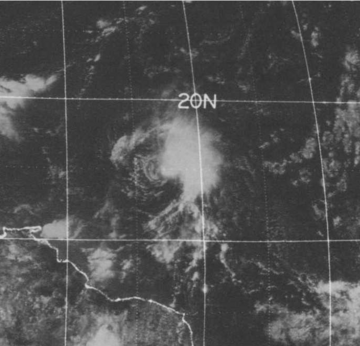
Satellite image of Tropical Storm Christine on September 1, 1973
|
|
| Formed | August 25, 1973 |
|---|---|
| Dissipated | September 4, 1973 |
| Highest winds | 1-minute sustained: 70 mph (110 km/h) |
| Lowest pressure | 996 mbar (hPa); 29.41 inHg |
| Fatalities | 1 indirect |
| Areas affected | Leeward Islands and Puerto Rico |
| Part of the 1973 Atlantic hurricane season | |
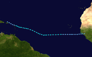
Tropical Storm Christine was a powerful weather system that formed in the Atlantic Ocean in 1973. It was special because it started very far east, closer to Africa, which was unusual for storms back then. Christine began as a weak tropical depression over the country of Guinea on August 25, 1973.
For several days, the storm moved west. It grew stronger and became a tropical storm on August 28. Experts didn't officially announce it until August 30, after a special plane flew into the storm to check its strength. Christine slowly got stronger, reaching its peak on September 2. At its strongest, it had winds of 70 mph (110 km/h), almost strong enough to be a hurricane. Soon after, it started to weaken quickly. By September 4, Christine was just a tropical depression as it moved through the Leeward Islands. Its last bits disappeared on September 6.
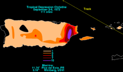
Even though Christine was weaker when it reached the islands, it brought a lot of rain. In Puerto Rico, some areas got over 11 inches (298 mm) of rain. This caused big floods, damaging over 600 homes. Many families had to leave their houses. Sadly, one person died from an electric shock after stepping on a power line in a flooded street. The Virgin Islands had only minor damage, mostly power lines knocked down, leaving about 500 people without phone service.
Contents
Christine's Journey: How It Formed
Tropical Storm Christine started from a "tropical wave" over Africa in late August. A tropical wave is like a ripple in the air that can sometimes create storms. This wave formed a tropical depression over Guinea on August 25. This was unusual because most storms like this form over the ocean, not over land.
The depression moved over the water a few hours later. It passed by the Cape Verde Islands on August 27. The next day, it became a tropical storm. However, the National Hurricane Center (NHC) didn't issue warnings until August 30. This was because they needed special planes, called reconnaissance aircraft, to fly into the storm and confirm its strength.
Once a German cargo ship reported strong winds, and a plane confirmed winds of 50 mph (85 km/h), the NHC issued its first warning. At that time, Christine was about 1,000 miles (1,500 km) east of Trinidad. Even though the storm wasn't perfectly organized, satellite pictures showed large rain bands stretching far out from its center.
How Christine Grew and Moved
By August 31, Christine started to slow down and turn towards the west-northwest. The NHC wasn't sure exactly where it would go or how strong it would get. Cooler ocean waters ahead of the storm made it harder for Christine to grow much stronger.
Christine continued on its path, slowly getting stronger. On September 2, it reached its strongest point, just below hurricane strength. This happened when it was about 300 miles (500 km) east of Guadeloupe. A reconnaissance plane measured winds of 70 mph (110 km/h). Soon after, strong winds high in the atmosphere, called wind shear, started to weaken Christine as it got closer to the Leeward Islands.
The NHC watched a weather system called a "trough" ahead of Christine. They thought this trough would decide the storm's future. It could either help Christine get much stronger or make it disappear. By September 3, the storm's center had separated from its rain clouds, and Christine weakened back into a tropical depression. A few hours later, it passed over Antigua with winds of 35 mph (55 km/h). The next day, it turned into a tropical wave near the Dominican Republic. The last parts of Christine disappeared on September 6.
Watching the Storm from Space
During Christine's existence, astronauts on the Skylab 3 mission watched it from space. This was a big step for weather forecasting. For the first time, they used special satellite images (microwave imagery) to figure out the wind speed inside a tropical storm. They did this by removing data from heavy rain areas, which can make wind readings wrong.
Christine's Impact: Rain and Flooding
On September 2, the National Hurricane Center issued warnings for islands like Guadeloupe, Antigua, and Barbuda. They warned about strong winds (gale warnings) and even the chance of a hurricane (hurricane watches). Later, these warnings were extended to islands south of Dominica. When Christine weakened to a tropical depression, all warnings were canceled.
As a safety step, schools in Puerto Rico and the United States Virgin Islands closed. Six scientists on the small island of Isla Aves had to be moved to safety. On St. Thomas, nine emergency shelters, mostly in schools, were opened. On September 5, disaster officials in Puerto Rico held a meeting about the risk of flooding. They told everyone to get their emergency kits ready and be prepared to leave if asked. Firefighters were also told to be ready to help with evacuations.
Flooding and Damage
As Christine moved through the Leeward Islands, it brought very heavy rain. The most rain, about 11.74 inches (298 mm), fell in eastern Puerto Rico. The United States Virgin Islands also got a lot of rain, up to 3.16 inches (80 mm). This rain caused flooding on several islands.
Sadly, one person died during the storm. They were electrocuted by a downed power line on a flooded road. Public works crews worked hard to keep roads clear. However, one road that was being built turned into a "sea of mud" because the water couldn't drain fast enough.
Several towns in Puerto Rico had flood damage, including Yabucoa, Humacao, Maunabo, Las Piedras, and Carolina.
- In Yabucoa, 40 families had to leave their homes, and 25 homes were damaged.
- Humacao had the worst flooding, with 60 families evacuated and 500 homes damaged.
- In Maunabo, six bridges, four sewer systems, and 14 homes were damaged.
- Another 21 people were evacuated from Las Piedras, and 41 homes were damaged.
- In Carolina, 23 more homes were damaged.
We don't know the exact cost of all this damage.
In the United States Virgin Islands, police received many calls about downed power lines. Strong winds, up to 40 mph (65 km/h), left about 500 people without phone service on St. Croix. Luckily, no major damage was reported on any of the affected islands after Christine passed.
 | Charles R. Drew |
 | Benjamin Banneker |
 | Jane C. Wright |
 | Roger Arliner Young |


