Tropical Storm Erika (2009) facts for kids
| Tropical storm (SSHWS/NWS) | |

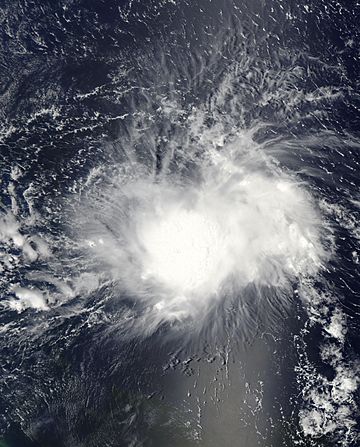
Tropical Storm Erika east of the Lesser Antilles on September 1
|
|
| Formed | September 1, 2009 |
|---|---|
| Dissipated | September 4, 2009 |
| (Remnant low after September 3) | |
| Highest winds | 1-minute sustained: 50 mph (85 km/h) |
| Lowest pressure | 1004 mbar (hPa); 29.65 inHg |
| Fatalities | None reported |
| Damage | $35,000 (2009 USD) |
| Areas affected | Lesser Antilles, Puerto Rico and the Dominican Republic |
| Part of the 2009 Atlantic hurricane season | |
Tropical Storm Erika was a storm that formed in the Atlantic Ocean in 2009. It was the fifth named storm of the 2009 Atlantic hurricane season. Erika brought some rain and minor problems to islands in the Lesser Antilles.
The storm started from a weather system called a tropical wave on September 1. It was near the Lesser Antilles islands. Even though it was not very organized, it quickly became a tropical storm. Later that day, Erika reached its strongest point. Its winds blew at 50 mph (85 km/h).
After reaching its peak, Erika began to weaken. Strong winds high in the atmosphere, called wind shear, made the storm fall apart. By September 2, it was barely a tropical storm. It then moved over the island of Guadeloupe and into the Caribbean Sea.
On September 3, Erika became even weaker, turning into a tropical depression. This means its center was no longer connected to its rain clouds. Soon after, it became just a leftover area of low pressure. Erika completely disappeared near Puerto Rico on September 4.
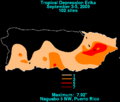
Because Erika was not a very strong storm, it did not cause much damage. Guadeloupe received a lot of rain, up to 12.1 in (310 mm). This caused some flooding and small landslides. About 12,000 people on the island lost electricity. Other islands also got some rain. In Puerto Rico, the storm's leftover clouds brought heavy rain, up to 7.58 in (193 mm). This led to flooding in several areas.
Contents
How Tropical Storm Erika Formed and Moved
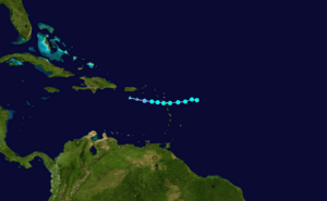
Tropical Storm Erika began as a tropical wave. This is a type of weather disturbance that moved off the coast of Africa on August 25. It had some scattered showers and thunderstorms with it. The next day, these storms started to get more organized as they moved west across the Atlantic Ocean.
By August 28, a low-pressure area formed from this wave. The weather conditions around it seemed good for the system to grow stronger. However, on August 29, the low-pressure area became less organized. There were not many thunderstorms left around its center.
But on August 30, the system quickly got organized again. Showers and thunderstorms started to form around its center. Weather experts thought it would become a tropical depression soon. Even though the storms looked good, the system did not have a clear center yet. So, it was not officially named at that time.
On September 1, a special plane called a Hurricane Hunter flew into the system. They found a clear center and strong winds. Because of this, the National Hurricane Center (NHC) officially named it Tropical Storm Erika. It was the fifth named storm of 2009.
Erika was a bit messy because of moderate wind shear. This means winds at different heights were blowing in different directions. But with warm ocean water, experts thought it would get stronger. The storm generally moved west because of a high-pressure area to its north.
A few hours after being named, Erika reached its strongest point. Its winds were 50 mph (85 km/h). Its lowest pressure was 1004 mbar. However, experts first thought it was stronger, with winds of 60 mph (95 km/h). They later found out they had overestimated the wind speeds.
By the morning of September 2, Erika became very disorganized. Hurricane Hunters even thought there might be more than one center of the storm.
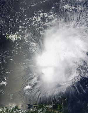
The wind shear increased faster than expected. This made the storm weaken into a minimal tropical storm. Around 2:30 PM UTC, Erika's center passed over Guadeloupe. Its winds were 40 mph (65 km/h). The storm then moved into the eastern Caribbean Sea.
The storm's circulation became stretched out and started to fall apart. Experts thought the center might reform somewhere else and get stronger. After a brief increase in rain, the storm weakened again due to wind shear. By the afternoon of September 3, Erika's center was completely separated from its rain clouds. The NHC then downgraded it to a tropical depression.
Soon after, it became just a leftover low-pressure area. This was the last time the NHC issued an advisory on Erika. The next day, the storm's leftovers moved near the southern coast of Puerto Rico. They brought heavy rain to the island. Erika's remnants were last seen on September 4, disappearing about 80 mi (140 km) south of Puerto Rico.
Getting Ready for the Storm

When Tropical Storm Erika was named on September 1, some islands got "tropical storm watches." These included St. Maarten, Antigua, Barbuda, St. Kitts, Nevis, Anguilla, St. Martin, and Saint Barthélemy. A watch means a tropical storm is possible.
The next day, these watches were upgraded to "tropical storm warnings." This means a tropical storm is expected. This happened as Erika got closer to the Lesser Antilles. When the storm moved into the Caribbean Sea, Dominica received a tropical storm warning. Puerto Rico, the U.S. Virgin Islands, and the British Virgin Islands got tropical storm watches.
Early on September 3, the watches for these islands were also upgraded to warnings. Later that day, the warnings for Dominica and Guadeloupe were canceled. Soon after, all other warnings were also removed.
In St. Croix, a large oil refinery stopped sending out oil. Ports on the island were closed to keep everyone safe. In Dominica, all businesses were shut down on September 3 because of the storm. Schools and the airport in Antigua and Barbuda were also closed as a safety step.
Two cruise ships changed their plans and stayed at sea for a few extra days. The islands of Saint Martin and Saint Barthélemy were put on an "orange alert." This is a medium alert level. Guadeloupe was on a "yellow alert," which is the lowest alert level.
In Puerto Rico, officials closed schools and government offices on September 4. They also opened 433 shelters across the island for people who needed a safe place. In the Dominican Republic, nine areas were put on warning. This was to prepare for possible heavy rains. Nearby Haiti was also warned about the chance of heavy rainfall.
What Happened After the Storm
On September 3, all government buildings in Dominica closed. This was due to flooding from Erika's heavy rain. Some landslides happened in Petite Savanne, blocking roads.
In Guadeloupe, Erika brought a lot of rain. Some areas got more than 7.9 in (200 mm). This caused flooding in Côte-sous-le-Vent. The most rain fell on La Désirade, with 12.1 in (310 mm). A record 9.4 in (240 mm) fell in just 24 hours. Winds reached 56 mph (90 km/h) on the island of Marie Galante. A rockslide happened near Losteau. Several roads became impossible to use because of floodwaters. At its peak, about 12,000 people on the island lost power.
Up to 5.5 in (140 mm) of rain fell in the foothills of Trinidad. In St. Martin, the highest rainfall was 3.7 in (94 mm). The United States Virgin Islands received up to 1.61 in (41 mm) of rain in 24 hours, causing minor flooding.
In Puerto Rico, the leftover parts of Erika caused significant rainfall. Rivers like La Plata, Loíza, and Caguitas overflowed. This led to widespread flooding. One weather station recorded 7.92 in (201 mm) of rain. Several other areas got more than 4 in (100 mm).
In Guanica, some homes were flooded, causing minor damage. The worst damage was in Las Piedras, with some flood losses reported. One river rose very high, much higher than its normal flood level. Flooding in Fajardo and Caguas also caused some damage to homes.
In the Dominican Republic, flood warnings were issued for several areas. This was because of the threat of continued rain and flooding.
Images for kids
 | George Robert Carruthers |
 | Patricia Bath |
 | Jan Ernst Matzeliger |
 | Alexander Miles |


