
Tulare Hill facts for kids
Quick facts for kids Tulare Hill |
|
|---|---|

Tulare Hill along Santa Teresa Boulevard
|
|
| Highest point | |
| Elevation | 620 ft (190 m) NGVD 29 |
| Prominence | 320 ft (98 m) NGVD 29 |
| Geography | |

Tulare Hill
Location in California
|
|
| Location | Santa Clara County, California, U.S. |
| Parent range | Santa Teresa Hills |
| Topo map | USGS Tulare Hill |
Tulare Hill is a well-known hill located in the Santa Teresa Hills in western Santa Clara County, California. It sits right at the southern edge of San Jose, California.
This hill and the land around it, about 330 acres, are special. They have a unique type of soil called serpentine soil. This area is home to two important and rare species: the endangered Bay checkerspot butterfly and a special wildflower called Dudleya setchellii.
Geography of Tulare Hill
Tulare Hill is positioned in a very interesting spot. It's in the narrowest space between two large mountain ranges: the Santa Cruz Mountains and the Diablo Range. From the hill, you can look down over the Laguna Seca wetlands, which are marshy areas, in the northern part of Coyote Valley.
History of Tulare Hill
A long time ago, in the early 1800s, Tulare Hill was part of much larger land areas. These lands were known as historic ranchos. Specifically, it was part of the Rancho Santa Teresa and Rancho Laguna Seca land grants. These were big pieces of land given out by the government back then.
Wildfires on the Hill
In August 2019, a brush fire happened on Tulare Hill. This fire burned about 60 acres of land on the southwestern side of the hill. A smaller area on the eastern side of the nearby Santa Teresa County Park was also affected by the fire.
Images for kids
-
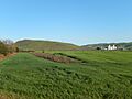
Tulare Hill along Santa Teresa Boulevard
