
Coyote Valley, California facts for kids
Quick facts for kids Coyote Valley |
|
|---|---|

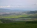
A view across the Coyote Valley towards Morgan Hill from Santa Teresa County Park, April 1, 2006
|
|
| Floor elevation | 260 feet (79 m) at Coyote, California |
| Length | 7 miles Northwest to Southeast |
| Width | 2 miles |
| Geography | |
| Location | California |
| Population centers | San Jose, California Coyote, California Morgan Hill, California |
| Borders on | Mount Hamilton, Diablo Range (east) Foothills of Santa Cruz Mountains (west) San Jose (north) Morgan Hill (south) |
| Traversed by | U.S. Highway 101, Monterey Highway |
Coyote Valley is a special place in Northern California. It's in the southern part of the Santa Clara Valley. This area is about 7,400 acres big. That's like 5,600 football fields!
You'll find lots of farms, fruit orchards, and nature areas there. The valley is split into three main parts: North Coyote Valley (part of San Jose), the small village of Coyote, California, and South Coyote Valley (part of Morgan Hill).
Coyote Valley is one of the biggest "greenbelts" in the San Francisco Bay Area. A greenbelt is an area of natural land kept free from buildings. Most of Coyote Valley is protected as open space, nature reserves, or farmland.
Years ago, there were plans to build many new homes and businesses here. But people spoke up, and those plans were stopped. Now, the valley is protected.
The northern part of Coyote Valley is very important for animals. It's a "wildlife corridor." This means it's a narrow path animals use to travel safely between the Diablo Range mountains in the east and the Santa Cruz Mountains in the west. In 2021, leaders in San Jose and Santa Clara County voted to keep Coyote Valley as open space and farmland forever.
Contents
Exploring Coyote Valley's Geography
Coyote Valley is a flat area that floods sometimes. It's about 7 miles (11.2 km) long and 2 miles (3.2 km) wide. It sits in a narrow spot in the Santa Clara Valley. The Diablo Range mountains are to its east, and the Santa Cruz Mountains are to its west.
The very northern tip of the valley is called the Coyote Gap. This is the narrowest point between the two mountain ranges, only about 0.37 miles (0.6 km) across. North Coyote Valley also has Laguna Seca. This is the biggest freshwater wetland in Santa Clara County. It's mostly a seasonal lake, meaning it dries up sometimes. It helps refill the underground water supply.
In 2001, Coyote Valley was named one of the "Last Chance Landscapes of America the Beautiful." It was the only place in California chosen. It was described as a "rare scenic break in an otherwise urbanized area." People loved its "rolling hills, blossoming orchards, and grand oaks." It offers a peaceful place for people and many kinds of wildlife.
The valley is mostly divided between San Jose and Morgan Hill. But it also includes the tiny village of Coyote. You can split the valley at Bailey Avenue. North Coyote Valley has San Jose addresses. South Coyote Valley has Morgan Hill addresses.
Amazing Animals of Coyote Valley
The wildlife corridor in Coyote Valley is about 2 kilometers (1.2 miles) wide. This is considered the smallest width needed for many different animals to move safely.
Since 2007, students and biologists from De Anza College have been watching the wildlife here. They've seen 160 different kinds of birds! Twenty-five of these birds are rare or have special protection.
Big roads like U.S. Highway 101 can make it hard for large mammals to move around. But Coyote Valley has special underpasses and culverts (tunnels under the road). These help animals like tule elk, pumas (also called mountain lions), coyotes, bobcats, gray foxes, and American badgers cross safely. These passages are the last safe ways for them to travel between the mountains on the west and east. Cameras have shown that deer, bobcats, pumas, and coyotes use these tunnels.
Tule elk were brought back to Mount Hamilton between 1978 and 1981. Sometimes, elk from the Mount Hamilton/Diablo side of the valley gather near Highway 101, waiting to cross.
Coyote Valley also has "vernal pools." These are temporary pools of water that form in the spring. They are safe places for amphibians like the California tiger salamander and the California red-legged frog.
Coyote Creek flows through the valley. This creek is very important for steelhead trout. These fish swim upstream in the creek to lay their eggs.
Protecting Coyote Valley's Future
For many years, people thought Coyote Valley would change a lot. There were plans for huge developments with thousands of homes and jobs. Some plans even included a big lake and a new public transport system.
However, these big development plans faced many problems. Developers stopped funding the planning process in 2008. There was also a lot of public concern about how these plans would affect the environment.
Why Development Plans Changed
When a large development is planned, a report is made to show its environmental effects. This is called an Environmental Impact Report (EIR). In 2007, a draft report for Coyote Valley was released. It received a huge amount of criticism. Over 1,000 pages of negative comments came in from 55 groups and individuals. Even 28 government agencies, like the U.S. Fish and Wildlife Service, had concerns.
Because of all the criticism, the city decided to redo much of the report. This would cost a lot of money and take a long time. This controversy helped lead to the end of the main development proposal.
On March 18, 2008, the developers announced they would no longer pay for the planning. This stopped the specific plan for the area. News reports said that more and more people were against the development. Environmental groups pointed out problems with the environmental and money analyses. They believed these issues helped end the proposal.
Some other developments were still possible. This included the Coyote Valley Research Park, which was approved but never built. Also, an expansion of the Gavilan College campus was proposed. In 2017, the first part of the Gavilan College Coyote Valley Center was finished. It now hosts police and fire training academies.
Coyote Valley Open Space Preserve
In November 2019, the San Jose City Council voted to buy 937 acres in northern Coyote Valley. This land was bought to be kept as open space. The City of San Jose kept 296 acres. The rest went to the Santa Clara Valley Open Space Authority. This is a government group that manages public open space.
Protecting the Valley for Good
In November 2021, the San Jose City Council made a big decision. They changed the zoning for northern Coyote Valley from industrial (for factories and businesses) to agricultural and open space. This means it will stay farmland and nature.
In December 2021, the Santa Clara County Board of Supervisors also voted to protect the middle and southern parts of Coyote Valley. They created a "Climate Resilience District." This helps protect the open space and farmland by limiting new buildings. These actions help ensure Coyote Valley remains a natural and agricultural area for the future.
Images for kids
-
A view across the Coyote Valley towards Morgan Hill from Santa Teresa County Park, April 1, 2006
