Tulare Lake (Alameda County) facts for kids
Quick facts for kids Tulare Lake |
|
|---|---|
|
|

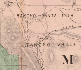
The extent of the marshland surrounding Tulare Lake in 1878
|
|
| Location | Amador Valley Alameda County, California |
| Coordinates | 37°40′N 121°54′W / 37.667°N 121.900°W |
| Type | Marsh (drained) |
| Etymology | Once characterized by tule rush |
| Primary inflows | Arroyo Mocho Arroyo Valle Arroyo Las Positas Tassajara Creek South San Ramon Creek |
| Primary outflows | Alameda Creek, via Arroyo de la Laguna |
| Catchment area | San Francisco Bay |
| Basin countries | United States |
| Settlements | Pleasanton, California Dublin, California Pelnen (Ohlone) Seunen (Ohlone) |
Imagine a large, shallow lake in the eastern part of the Amador Valley in California. This was once Tulare Lake. It was surrounded by a big marshy area called Willow Marsh, also known as the Lagoon.
This lake and marsh were home to many plants. You would have seen tall tule rushes and willow trees growing along its edges. But things changed a lot starting in the 1800s. People began to drain the land. This caused the marsh to shrink down to just one waterway, the Arroyo de la Laguna. Today, the city of Pleasanton covers much of what used to be this marshland. These big changes have made the water flow in Niles Canyon quite tricky, especially during different seasons.
Contents
What Was Tulare Lake Like?
Tulare Lake was not like a deep, clear mountain lake. It was a wide, shallow body of water. It was more like a large wetland or marsh. This type of environment is very important for nature. It provides homes for many different animals and plants.
Plants and Wildlife
The name "Tulare" comes from the tule rush. These tall, grass-like plants were very common there. They grew thick in the marshy areas. Willow trees also grew along the shores. These plants created a perfect habitat. Many birds, fish, and other creatures would have lived in and around the lake.
How Tulare Lake Was Formed
Tulare Lake was a natural part of the Amador Valley. It was fed by several creeks. These creeks brought water from the surrounding hills.
The Creeks That Fed the Lake
The main creeks that flowed into Tulare Lake were:
- Arroyo Mocho
- Arroyo Valle
- Arroyo Las Positas
- Tassajara Creek
Other smaller creeks from the Amador Valley also contributed water. These creeks only reached the lake when there was enough rain. This means the lake's size could change a lot. It would get bigger after heavy rains and shrink during dry times.
Where the Water Went
The lake had a natural way for water to leave it. This was through the Arroyo de la Laguna. This creek acted as the lake's seasonal outlet. It would carry water away, especially when the lake was full. Eventually, this water would make its way to Alameda Creek and then to San Francisco Bay.
Why Tulare Lake Disappeared
Over time, people changed the land around Tulare Lake. These changes led to the lake's disappearance.
Drainage and Development
Starting in the 19th century, people began to alter the natural drainage of the area. This was often done to create farmland or to build towns. They dug ditches and canals to move water away from the marsh. This dried out the land. As the land became drier, it was easier to build on. The city of Pleasanton grew across what was once the marsh. This development changed the landscape forever.
Impact on Water Flow
The changes to the land and water flow had big effects. The natural seasonal changes in water levels became harder to manage. This led to "tricky seasonal flow variations" in nearby areas like Niles Canyon. It shows how connected natural water systems are. When one part is changed, it can affect many other parts.
 | Jewel Prestage |
 | Ella Baker |
 | Fannie Lou Hamer |


