Tuxedo, New York facts for kids
Quick facts for kids
Tuxedo, New York
|
|
|---|---|
| Town of Tuxedo | |
|
Town Hall
|
|
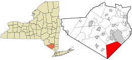
Location in Orange County and the state of New York.
|
|
| Country | United States |
| State | New York |
| County | Orange |
| Area | |
| • Total | 49.34 sq mi (127.80 km2) |
| • Land | 47.05 sq mi (121.85 km2) |
| • Water | 2.30 sq mi (5.95 km2) |
| Elevation | 479 ft (146 m) |
| Population
(2020)
|
|
| • Total | 3,811 |
| • Density | 81.00/sq mi (31.28/km2) |
| Time zone | UTC-5 (EST) |
| • Summer (DST) | UTC-4 (EDT) |
| ZIP code |
10987
|
| Area code(s) | 845, 329 |
| FIPS code | 36-75781 |
| GNIS feature ID | 0979566 |
Tuxedo is a town in Orange County, New York, in the United States. It's located along the Ramapo River. In 2020, about 3,811 people lived there. The town is in the southeastern part of the county, nestled in the Ramapo Mountains. Major roads like New York State Route 17 and the New York State Thruway (which is Interstate 87) go through the town. The name "Tuxedo" comes from a Lenape word, tucseto, which has a few different meanings.
Contents
History of Tuxedo
The first people to live in the area that is now Tuxedo were the Lenape, a Native American group. They were part of the larger Algonquian language family. The Lenape named the biggest lake in the area Tucseto. This name meant either "place of the bear" or "clear flowing water." Later, European settlers used this name for the town they built.
Some Lenape people stayed in villages in the Ramapo Mountains. They had moved west from Connecticut. Over time, they married people from other groups. They kept their own culture and community in this area, which crossed into what is now New Jersey. The Ramapough Mountain Indians are recognized as a Native American tribe in New Jersey.
Early Settlements (1700s)
In the 1700s, settlers from England and Germany came to the area. Many of them worked at the Sterling Iron Works in nearby Sterling Forest. Some Ramapough Mountain Indians also worked there. Several men from Tuxedo fought in the American Revolution.
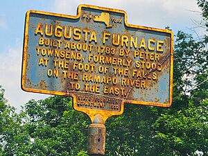
In 1779, during the war, a road called the Continental Road was built. It went through what is now the village of Tuxedo Park. The first business in Tuxedo was the Augusta Forge. Solomon Townsend started it in 1783 at the falls on the Ramapo River.
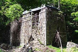
The town of Southfields, which is now part of Tuxedo, was renamed Monroe in 1808. An iron forge also operated in Southfields. You can still see the ruins of this forge today. The oldest building in Tuxedo is the Adam Belcher house, built in 1790 in Southfields.
Growth and Industry (1800s)
By 1812, the Augusta Forge closed down. Pierre Lorillard II, who owned a tobacco business, bought the land. Mining continued until the 1840s, when most of the iron ore was gone. The Lorillard family then used the land for cutting timber. This wood helped fuel the Erie Railroad, which was built in 1841.
The southern part of Tuxedo, called Eagle Valley, was used for farming. Other farming areas were Helmsburg and Bramertown, named after early settlers. In the northern part of town, in an area called Arden, the Greenwood Furnace was built in 1810. During the American Civil War, this forge made iron for the famous Parrott rifles.
The Southfields Methodist Church was built in 1848. The Parrott family built St. John's Episcopal Church in Arden in 1863. By the 1890s, the iron industry in the area slowed down. This was because there was less ore, and new, richer iron mines were found in Minnesota.
The Town of Tuxedo was created twice from the Town of Monroe. It was first called the Town of Southfields in 1863. But in 1865, it became part of Monroe again. Finally, on December 19, 1889, the county leaders approved making Tuxedo a separate town. This officially happened on March 4, 1890.
Tuxedo Park: A Special Community
Pierre Lorillard IV had the idea to create a planned community called Tuxedo Park. In 1884, he started buying land to build a hunting and fishing resort around Tuxedo Lake. The project was huge! About 1,800 workers, mostly immigrants from Italy and Slovakia, built it in about 18 months.
When the Tuxedo Club opened in 1886, it had many features. There were 30 miles of roads, 40 buildings, a boathouse, a school, and a golf course. It also had indoor tennis courts, a game preserve, a swimming pool, and even an electric toboggan run. It was one of the first places outside big cities to have water, sewer, and telephone systems.
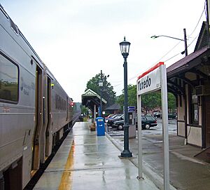
This resort attracted many wealthy and important people, especially those who worked in New York City. Over the next 30 years, more than 250 houses and stables were built. There were also shops, three churches, a train station, a library, a post office, a school, and a hospital. Business people could easily travel to New York City by train.
Modern Times (1900s)
By 1915, Tuxedo had 3,636 people living there. This was about 20% more than in 1890.
A big change happened in Tuxedo after 1910. Mrs. W. A. Harriman gave a lot of money and land to the Palisades Interstate Park Commission. The state then bought more land from many owners. This led to the creation of Bear Mountain-Harriman State Park. This park now covers about 12,500 acres of Tuxedo's land.
In the 1920s, a new hospital and high school were built with donations from residents. However, the Wall Street Crash of 1929 (a big economic downturn) hurt Tuxedo Park. Many residents lost their jobs in finance. This led to a slow decline in the community. The hospital closed, and many shops disappeared.
In 1956, the Harriman family sold their Sterling Mine and Railroad Company land. This land was developed into new housing areas like Maple Brook and Laurel Ridge. It also became home to offices and research centers.
In 1952, the area known as Tuxedo Park became its own village. Today, it covers about 2,050 acres, including three lakes. It has about 340 homes. Other new housing areas include the Southfields Apartments and the Woodlands in Eagle Valley.
The men's formal evening wear, known as a "tuxedo," got its name from the wealthy residents of Tuxedo Park.
The historic district of Tuxedo Park was recognized for its importance. It was listed on the National Register of Historic Places in 1980. This honor helps protect the area's history and buildings.
Geography of Tuxedo
Tuxedo covers about 49.4 square miles. Most of this is land, with about 1.9 square miles of water. This means about 3.89% of the town is water.
The eastern border of Tuxedo is the border of Rockland County. The Ramapo River flows through the town. The town is located within the Ramapo Mountains.
Major roads like the New York State Thruway and NY-17 pass through Tuxedo.
Population of Tuxedo
| Historical population | |||
|---|---|---|---|
| Census | Pop. | %± | |
| 1890 | 1,678 | — | |
| 1900 | 2,277 | 35.7% | |
| 1910 | 2,858 | 25.5% | |
| 1920 | 2,355 | −17.6% | |
| 1930 | 2,606 | 10.7% | |
| 1940 | 2,314 | −11.2% | |
| 1950 | 2,281 | −1.4% | |
| 1960 | 2,227 | −2.4% | |
| 1970 | 2,967 | 33.2% | |
| 1980 | 3,069 | 3.4% | |
| 1990 | 3,023 | −1.5% | |
| 2000 | 3,334 | 10.3% | |
| 2010 | 3,624 | 8.7% | |
| 2020 | 3,811 | 5.2% | |
| U.S. Decennial Census | |||
In 2000, there were 3,334 people living in Tuxedo. There were 1,337 households and 962 families. The town had about 70 people per square mile. Most of the people were White (92.68%). There were also African American (1.23%), Native American (0.33%), and Asian (3.21%) residents. About 4.26% of the population was Hispanic or Latino.
Fun Things to Do in Tuxedo
Tuxedo is home to the yearly New York Renaissance Faire. It's a fun event where people dress up and celebrate the Renaissance period.
Education in Tuxedo
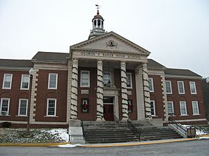
The Tuxedo Union Free School District provides public education in the area. It includes the George F. Baker High School and the George Grant Mason School. The Tuxedo Park School is a private school located in the village of Tuxedo Park.
Communities and Places in Tuxedo
- Arden — A small community near the northern border of the town.
- Eagle Valley — A community in the southern part of the town.
- Harriman State Park — A large state park that partly lies within the town.
- Indian Hill — A community in the northern part of the town.
- Southfields — A community north of Tuxedo Park, located on highway NY-17.
- Sterling Forest — A community north of Tuxedo Park on highway NY-17A. This is where Sterling Forest State Park is located.
- Tuxedo Lake — A lake in the southern part of the town.
- Tuxedo Park — A village in the southern part of the town, near highway NY-17.
Notable People from Tuxedo
- Walt Weiss — A former professional baseball player and manager. He is currently a coach for the Atlanta Braves.
See also
 In Spanish: Tuxedo (Nueva York) para niños
 | Aaron Henry |
 | T. R. M. Howard |
 | Jesse Jackson |


