Union County, South Dakota facts for kids
Quick facts for kids
Union County
|
|
|---|---|

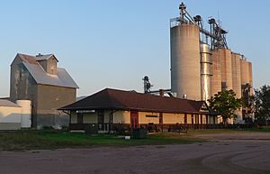
Chicago and North Western Railway depot in Beresford, South Dakota
|
|

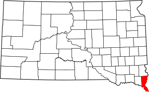
Location within the U.S. state of South Dakota
|
|
 South Dakota's location within the U.S. |
|
| Country | |
| State | |
| Founded | April 10, 1862 |
| Seat | Elk Point |
| Largest community | Dakota Dunes |
| Area | |
| • Total | 467 sq mi (1,210 km2) |
| • Land | 461 sq mi (1,190 km2) |
| • Water | 6.6 sq mi (17 km2) 1.4% |
| Population
(2020)
|
|
| • Total | 16,811 |
| • Estimate
(2023)
|
17,183 |
| • Density | 36.00/sq mi (13.899/km2) |
| Time zone | UTC−6 (Central) |
| • Summer (DST) | UTC−5 (CDT) |
| Congressional district | At-large |
Union County is a county located in the very southern part of South Dakota, a state in the United States. In 2020, about 16,811 people lived here, making it the 13th most populated county in South Dakota. The main town, or county seat, is Elk Point. It has been the county seat since April 30, 1865.
The county was first called Cole County. But on January 7, 1864, its name was changed to Union. This change happened because of strong feelings during the American Civil War. Union County is also part of the larger Sioux City metropolitan area, which includes parts of Iowa, Nebraska, and South Dakota. In 2006, The Progressive Farmer magazine said Union County was one of the "Best Places to Live" in the U.S. They liked its good schools, tidy towns, and friendly people.
Contents
History of Union County
Union County was first created on April 10, 1862, and was known as Cole County. Its name changed to Union County on January 7, 1864. At that time, its borders also changed to include land that used to be part of Lincoln County. The county seat, which is the main town where the county government is located, moved from Richland to Elk Point on April 30, 1865.
Geography of Union County
Union County is located in the southeast corner of South Dakota. Its eastern border is next to Iowa, across the Big Sioux River. Its southern border is next to Nebraska, across the Missouri River. A creek called Brule Creek flows through the middle of the county, heading southeast and emptying into the Big Sioux River.
The land in Union County has rolling hills. Most of the land is used for farming, except for the areas where towns are built. The land slopes down towards the south and east. The highest point in the county is in its northwest corner, about 1,509 feet (460 meters) above sea level. The county covers a total area of 467 square miles (1,210 square kilometers). Of this, 461 square miles (1,190 square kilometers) is land, and 6.6 square miles (17 square kilometers) is water. It is the fifth-smallest county in South Dakota by land area.
Major Roads in Union County
Neighboring Counties
- Lincoln County to the north
- Sioux County, Iowa to the northeast
- Plymouth County, Iowa to the east
- Woodbury County, Iowa to the southeast
- Dakota County, Nebraska to the south
- Dixon County, Nebraska to the southwest
- Clay County to the west
Protected Natural Areas
- Adams Homestead and State Nature Preserve
- Bent River State Game Production Area
- Bolton State Game Production Area
- Cusick State game Production Area
- Cut Off Bend State Game Production Area
- Missouri National Recreational River (part of it)
- Petry-Conway State Game Production Area
- Petry/Harmelink State Game Production Area
- Ryan State Game Production Area
- Union Grove State Park
- Warren Wilderness State Game Production Area
Lakes in Union County
- Burbank Lake (part of it)
- McCook Lake
- Mud Lake
Population and People
| Historical population | |||
|---|---|---|---|
| Census | Pop. | %± | |
| 1870 | 3,507 | — | |
| 1880 | 6,813 | 94.3% | |
| 1890 | 9,130 | 34.0% | |
| 1900 | 11,153 | 22.2% | |
| 1910 | 10,676 | −4.3% | |
| 1920 | 11,099 | 4.0% | |
| 1930 | 11,480 | 3.4% | |
| 1940 | 11,675 | 1.7% | |
| 1950 | 10,792 | −7.6% | |
| 1960 | 10,197 | −5.5% | |
| 1970 | 9,643 | −5.4% | |
| 1980 | 10,938 | 13.4% | |
| 1990 | 10,189 | −6.8% | |
| 2000 | 12,584 | 23.5% | |
| 2010 | 14,399 | 14.4% | |
| 2020 | 16,811 | 16.8% | |
| 2023 (est.) | 17,183 | 19.3% | |
| U.S. Decennial Census 1790-1960 1900-1990 1990-2000 2010-2020 |
|||
2020 Census Information
In 2020, the census counted 16,811 people living in Union County. There were 6,822 households and 4,613 families. This means there were about 36.5 people per square mile. There were also 7,215 homes or housing units.
2010 Census Information
According to the 2010 census, there were 14,399 people in the county. About 95.5% of the people were white. Other groups included Asian (0.9%), black or African American (0.7%), and American Indian (0.6%). About 2.1% of the population was of Hispanic or Latino origin.
Many people in Union County have ancestors from Germany (42.0%), Norway (18.2%), or Ireland (17.7%). The average age of people in the county was 40.2 years old. The average income for a household was $59,889. About 4.9% of all people in the county lived below the poverty line.
Towns and Communities
Cities in Union County
- Alcester
- Beresford (part of this city is in another county)
- Elk Point (the county seat)
- Jefferson
- North Sioux City
Census-Designated Places
These are areas that are like towns but are not officially incorporated as cities.
Unincorporated Communities
These are small communities that are not officially part of a city or town.
- Alsen
- Garryowen
- Junction City
- McCook Lake
- Midway
- Nora
- Spink
- Wynstone
Ghost Towns
These are places where towns once existed but are now abandoned.
- Emmet
- Gothland (in Alcester Township)
- Hill Side (in Emmet Township)
- Texas (in Elk Point Township)
- Morganfield
Townships
Townships are smaller areas within a county, often used for local government.
- Alcester
- Big Sioux
- Big Springs
- Brule
- Civil Bend
- Elk Point
- Emmet
- Jefferson
- Prairie
- Richland
- Sioux Valley
- Spink
- Virginia
Unorganized Territory
- Richland
See also
 In Spanish: Condado de Union (Dakota del Sur) para niños

