Upper Chichester Township, Pennsylvania facts for kids
Quick facts for kids
Upper Chichester Township, Pennsylvania
|
|
|---|---|
|
Township
|
|

|
|

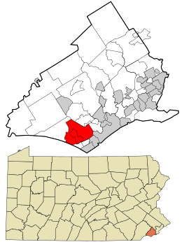
Location in Delaware County and the state of Pennsylvania.
|
|

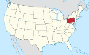
Location of Pennsylvania in the United States
|
|
| Country | United States |
| State | Pennsylvania |
| County | Delaware |
| Area | |
| • Total | 6.70 sq mi (17.34 km2) |
| • Land | 6.69 sq mi (17.32 km2) |
| • Water | 0.01 sq mi (0.02 km2) |
| Elevation | 98 ft (30 m) |
| Population
(2010)
|
|
| • Total | 16,738 |
| • Estimate
(2016)
|
16,992 |
| • Density | 2,540.67/sq mi (980.99/km2) |
| Time zone | UTC-5 (EST) |
| • Summer (DST) | UTC-4 (EDT) |
| ZIP code |
19061
|
| Area code(s) | 610 |
| FIPS code | 42-045-78776 |
| Communities | Boothwyn Ogden Twin Oaks |
Upper Chichester Township is a township located in Delaware County, Pennsylvania, in the United States. A township is a type of local government area. In 2010, about 16,738 people lived here.
Contents
History of Upper Chichester Township
Early Settlers and European Claims
Long ago, the Lenni Lenape Native Americans were the first people to live in the Upper Chichester area. They built villages and lived by fishing, hunting, and some farming.
In the 1600s, both New Sweden (in 1643) and the Dutch (in 1654) claimed this land. However, they were mostly interested in trading with the Lenni Lenape people.
William Penn's Grant and English Settlers
The first European settlers arrived in Upper Chichester in 1681. This was after William Penn received a large land grant from King Charles II. Most of these early settlers were English and Welsh, and many were Quakers. Quakers are a religious group known for their peaceful beliefs.
How Chichester Was Divided
Upper Chichester Township was once part of a larger area called Chichester. This original Chichester included what are now Upper and Lower Chichester. The name "Chichester" comes from a town in West Sussex, England, where many of the first settlers came from.
Upper Chichester Township, sometimes called "Chichester Liberty," is thought to be one of the very first places settled in Pennsylvania.
Important Early Roads and Boundaries
One of the first settlers was Walter Martin, who founded St. Martin's Church in the late 1600s. Roads were important for travel and trade. The road from Chichester to Aston was built in 1688. The Upper Chichester road was laid out on October 25, 1687.
A special boundary line called the "Twelve-Mile Circle" (which marks the northern border of Delaware) also crosses this area.
Separation of Upper and Lower Chichester
Chichester was divided into Upper and Lower Chichester around 1700. This was done to make it easier to manage public business. In 1753, there was a big push to make this division official. At first, some people in Lower Chichester didn't want the separation. They thought the township was fine as it was and that money should be spent on fixing roads or helping the poor instead of on a survey for separation.
However, over six years, everyone realized that separating the townships was a good idea. In August 1759, almost all the landowners in Upper and Lower Chichester, and even in Nether Providence, signed a petition to officially separate the two townships.
Modern History and Landmarks
Edwin Booth was a major landowner in Upper Chichester Township. The town of Boothwyn is named after him. "Booth's Corner," a local Pennsylvania Amish market, also gets its name from his former land.
Upper Chichester officially became a "first class township" on December 30, 1941. This means it has a specific type of local government.
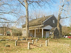
The Chichester Friends Meetinghouse is a historic building. It is listed on the National Register of Historic Places, which means it's an important place to protect.
Geography of Upper Chichester
Upper Chichester Township is in the southwestern part of Delaware County. It is west of the city of Chester.
Borders and Communities
- To the south, it borders the state of Delaware.
- To the west, it borders Bethel Township.
- To the north, it borders Aston Township.
- To the east, it borders Chester Township and the city of Chester.
- To the south, it borders the borough of Trainer and Lower Chichester Township.
The community of Boothwyn is located in the middle and southern parts of the township. Another community called Ogden and Twin Oaks are also in Upper Chichester.
Land and Water
The township covers about 6.70 square miles (17.34 square kilometers) in total. Most of this area is land, about 6.69 square miles (17.32 square kilometers). A very small part, about 0.01 square miles (0.03 square kilometers), is water.
Important waterways in Upper Chichester include Naaman's Creek and Marcus Hook Creek.
Education in Upper Chichester
Upper Chichester is part of the Chichester School District. Children living in the township usually go to these schools:
- Boothwyn Elementary School (Kindergarten to 4th grade)
- Hilltop Elementary School (Kindergarten to 4th grade)
- Chichester Middle School (5th to 8th grade)
- Chichester High School (9th to 12th grade)
Population and People
| Historical population | |||
|---|---|---|---|
| Census | Pop. | %± | |
| 1930 | 3,743 | — | |
| 1940 | 5,280 | 41.1% | |
| 1950 | 6,997 | 32.5% | |
| 1960 | 9,682 | 38.4% | |
| 1970 | 11,414 | 17.9% | |
| 1980 | 14,377 | 26.0% | |
| 1990 | 15,044 | 4.6% | |
| 2000 | 16,842 | 12.0% | |
| 2010 | 16,738 | −0.6% | |
| 2020 | 16,898 | 1.0% | |
| U.S. Decennial Census | |||
In 2010, the total population of Upper Chichester Township was 16,738 people.
Racial Makeup of the Population
Based on the 2010 Census, here's a look at the different groups of people living in the township:
- 84.0% were White.
- 10.7% were African American.
- 0.3% were Native American.
- 2.7% were Asian.
- 0.5% were from other races.
- 1.8% were from two or more races.
- About 2.4% of the population identified as Hispanic or Latino (of any race).
Households and Families
In 2000, there were 16,842 people living in 6,500 households. About 4,439 of these were families.
- 30.3% of households had children under 18 living with them.
- 52.9% were married couples living together.
- 11.2% had a female head of household with no husband present.
- 26.0% of all households were made up of individuals living alone.
- 10.9% had someone living alone who was 65 years old or older.
The average household had 2.58 people, and the average family had 3.15 people.
Age Distribution
The population was spread out by age:
- 23.6% were under 18 years old.
- 8.0% were between 18 and 24.
- 32.6% were between 25 and 44.
- 22.9% were between 45 and 64.
- 12.9% were 65 years or older.
The average age in the township was 37 years.
Transportation in Upper Chichester
As of 2020, Upper Chichester Township has about 67.53 miles of public roads. The Pennsylvania Department of Transportation (PennDOT) maintains 20.81 miles, and the township itself maintains 46.72 miles.
Major Highways
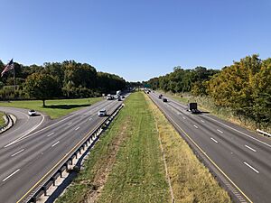
- Interstate 95 is the main highway. It runs through the southeastern part of the township.
- U.S. Route 322 connects with I-95 at the eastern border. It then heads northwest through the northern parts of the township.
- Pennsylvania Route 452 follows Market Street, running north and south through the eastern parts of the township.
- Pennsylvania Route 491 follows Naamans Creek Road, running northwest to southeast through the southwestern parts of the township.
Notable People from Upper Chichester
Many interesting people have connections to Upper Chichester Township:
- Anna Broomall, a doctor who was a pioneer in obstetrics (childbirth medicine).
- John Martin Broomall, who served as a U.S. Representative.
- Peirce Crosby, a Rear Admiral in the U.S. Navy.
- Curly Ogden, a professional baseball pitcher.
- Jack Ogden, also a professional baseball pitcher.
- Ron Bennington, a well-known radio host and comedian.
See also
 In Spanish: Municipio de Upper Chichester para niños
 | Frances Mary Albrier |
 | Whitney Young |
 | Muhammad Ali |


