Upper Makefield Township, Pennsylvania facts for kids
Quick facts for kids
Upper Makefield Township, Pennsylvania
|
|
|---|---|
|
Township
|
|

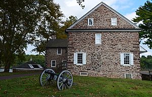
McConkey's Ferry Inn at Washington Crossing Historic Park
|
|

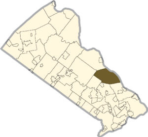
Location of Upper Makefield Township in Bucks County, Pennsylvania
|
|
| Country | United States |
| State | Pennsylvania |
| County | Bucks |
| Area | |
| • Total | 21.80 sq mi (56.5 km2) |
| • Land | 21.25 sq mi (55.0 km2) |
| • Water | 0.55 sq mi (1.4 km2) |
| Elevation | 161 ft (49 m) |
| Population
(2010)
|
|
| • Total | 8,190 |
| • Estimate
(2016)
|
8,392 |
| • Density | 375.69/sq mi (145.05/km2) |
| Time zone | UTC-5 (EST) |
| • Summer (DST) | UTC-4 (EDT) |
| Area code(s) | 215, 267, 445 |
| FIPS code | 42-017-79128 |
Upper Makefield Township is a community in Bucks County, Pennsylvania. It is a type of local government area called a township. It is located in the Delaware Valley region. This area is also considered part of the larger New York metropolitan area.
In 2010, about 8,190 people lived here. Upper Makefield Township is known for being a wealthy area. It has the eighth-highest income per person among all townships in Pennsylvania.
In 2006, Philadelphia magazine called it the "Best Place to Live in the Suburbs." This was because of its expensive homes, excellent public schools, and easy travel to New York City and Princeton. It is one of the most expensive suburbs near Philadelphia. It has also been suggested as a summer vacation spot.
Contents
History of Upper Makefield
Upper Makefield Township has an important place in American history. George Washington and his army, the Continental Army, crossed the Delaware River here. This famous event happened on the night of December 25–26, 1776.
This crossing was a key moment during the American Revolutionary War. It led to a big victory for the Americans. The Battle of Trenton happened the very next morning, on December 26.
Many historic places in the township are listed on the National Register of Historic Places. These include the Brownsburg Village Historic District and the Keith House-Washington's Headquarters. These sites help us remember the past.
Geography and Nature
Upper Makefield Township covers about 21.5 square miles (55.8 square kilometers). Most of this area is land. About 0.6 square miles (1.6 square kilometers) is water.
Some of the well-known places within the township are Buckmanville, Dolington, and Washington Crossing. Natural features include Houghs Creek and Jericho Mountain. Pidcock Creek also flows through the area.
Population and People
| Historical population | |||
|---|---|---|---|
| Census | Pop. | %± | |
| 1930 | 951 | — | |
| 1940 | 950 | −0.1% | |
| 1950 | 1,410 | 48.4% | |
| 1960 | 1,991 | 41.2% | |
| 1970 | 2,905 | 45.9% | |
| 1980 | 4,577 | 57.6% | |
| 1990 | 5,949 | 30.0% | |
| 2000 | 7,180 | 20.7% | |
| 2010 | 8,190 | 14.1% | |
| 2020 | 8,857 | 8.1% | |
In 2010, the population of Upper Makefield Township was 8,190 people. Most residents were White, making up 93.0% of the population. About 2.5% were Asian, and 1.1% were Black or African American.
In 2000, there were 7,180 people living in the township. There were 2,512 households. Many families lived there, with 77.3% being married couples. About 37.9% of households had children under 18.
The average household had 2.86 people. The average family had 3.13 people. The median age in the township was 42 years old. This means half the people were older than 42 and half were younger.
The median income for a household was $102,759. For families, it was $114,064. The income per person was $56,288. Only a small number of families, about 1.6%, lived below the poverty line.
Climate and Weather
Upper Makefield Township has a type of weather called a humid continental climate. This means it has hot summers and gets rain all year. Summers can be very hot and humid. Sometimes, the heat index can feel like 100°F (38°C) or more.
Winters can be very cold and windy. The wind chill can sometimes feel like 0°F (-18°C) or colder. July is usually the wettest month. This is when most thunderstorms happen. February is usually the snowiest month.
The average yearly snowfall is between 24 and 30 inches (61 and 76 cm). The area is in plant hardiness zone 6b. This means the coldest temperature it usually gets is around -0.2°F (-17.9°C).
| Climate data for Upper Makefield Township, Bucks County, Pennsylvania (1981 – 2010 averages) | |||||||||||||
|---|---|---|---|---|---|---|---|---|---|---|---|---|---|
| Month | Jan | Feb | Mar | Apr | May | Jun | Jul | Aug | Sep | Oct | Nov | Dec | Year |
| Mean daily maximum °F (°C) | 39.7 (4.3) |
43.0 (6.1) |
51.2 (10.7) |
63.2 (17.3) |
73.0 (22.8) |
82.1 (27.8) |
86.4 (30.2) |
84.6 (29.2) |
77.7 (25.4) |
66.3 (19.1) |
55.3 (12.9) |
44.1 (6.7) |
64.0 (17.8) |
| Daily mean °F (°C) | 31.4 (−0.3) |
34.1 (1.2) |
41.5 (5.3) |
52.2 (11.2) |
61.8 (16.6) |
71.3 (21.8) |
75.9 (24.4) |
74.3 (23.5) |
67.1 (19.5) |
55.4 (13.0) |
45.8 (7.7) |
36.0 (2.2) |
54.0 (12.2) |
| Mean daily minimum °F (°C) | 23.1 (−4.9) |
25.2 (−3.8) |
31.8 (−0.1) |
41.3 (5.2) |
50.6 (10.3) |
60.5 (15.8) |
65.5 (18.6) |
64.0 (17.8) |
56.5 (13.6) |
44.5 (6.9) |
36.3 (2.4) |
27.9 (−2.3) |
44.0 (6.7) |
| Average precipitation inches (mm) | 3.51 (89) |
2.77 (70) |
4.14 (105) |
4.01 (102) |
4.28 (109) |
4.40 (112) |
5.20 (132) |
4.20 (107) |
4.41 (112) |
3.89 (99) |
3.68 (93) |
4.10 (104) |
48.59 (1,234) |
| Average relative humidity (%) | 65.6 | 62.2 | 58.0 | 57.4 | 61.9 | 66.1 | 66.2 | 68.8 | 69.8 | 69.0 | 67.4 | 67.3 | 65.0 |
| Average dew point °F (°C) | 21.2 (−6.0) |
22.5 (−5.3) |
27.8 (−2.3) |
37.6 (3.1) |
48.6 (9.2) |
59.4 (15.2) |
63.8 (17.7) |
63.4 (17.4) |
56.9 (13.8) |
45.4 (7.4) |
35.6 (2.0) |
26.2 (−3.2) |
42.5 (5.8) |
| Source: PRISM Climate Group | |||||||||||||
Transportation and Roads
As of 2018, Upper Makefield Township had about 84.76 miles of public roads. The Pennsylvania Department of Transportation (PennDOT) takes care of about 30.88 miles of these roads. The township itself maintains the other 53.88 miles.
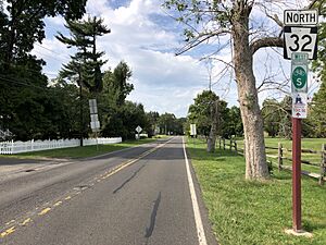
Several important highways pass through Upper Makefield Township. These include Pennsylvania Route 32 (PA 32), Pennsylvania Route 232 (PA 232), and Pennsylvania Route 532 (PA 532). PA 32, also known as River Road, runs along the Delaware River. PA 232, or Windy Bush Road, crosses the northwestern part of the township. PA 532, or Washington Crossing Road, goes through the southeastern part. It ends at PA 32 near the Washington Crossing Bridge.
Local Ecology
The natural plant life in Upper Makefield Township is mostly Oak trees. This area is part of what is called an Appalachian Oak vegetation type. The main type of forest found here is an Eastern Hardwood Forest. This means you would see many different kinds of trees with broad leaves.
See also
 In Spanish: Municipio de Upper Makefield para niños


