Uxbridge Rural District facts for kids
Quick facts for kids Uxbridge Rural District |
|
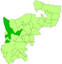
 This map shows the Uxbridge Rural District in 1911. It was part of Middlesex, a county in England. The dark green area is the district. You can see that some areas like Ruislip and Hayes had already left to form their own districts. The small Uxbridge Urban District was always separate. |
|
| Geography | |
| Status | Rural district |
| HQ | Uxbridge |
| History | |
| Created | 1875 (as a sanitary district) |
| Abolished | 1929 |
| Succeeded by | Uxbridge Urban District |
The Uxbridge Rural District was a type of local government area in Middlesex, England. It existed from 1894 until 1929. This district helped manage local services for people living in the countryside around the town of Uxbridge.
Contents
What Was the Uxbridge Rural District?
The Uxbridge Rural District was a special area created to manage local services. It was like a local council for rural areas. Before 1894, it was known as the Uxbridge rural sanitary district. This earlier group was set up in 1875. Its main job was to look after public health, like clean water and waste.
Alongside this, there was also the Uxbridge Poor Law Union. This group helped people who were poor or needed support. Both the sanitary district and the Poor Law Union covered the same area. They worked together until 1894.
The district did not include a few small areas to the south and east. These areas were part of an old medieval unit called Elthorne Hundred.
In 1883, a small part of Hillingdon parish moved. This part joined the main town area of Uxbridge. Later, in 1891, the area of Northwood also left. It became its own urban sanitary district.
Around this time, new local councils called civil parish councils started. These new councils took over from an older system. That system was called the vestries. Vestries were often run by local church leaders.
How the District Was Formed
The Local Government Act 1894 was a very important law. It changed how local areas were governed. This law turned the old rural sanitary districts and poor law bodies into new rural districts. These new districts had councils. People living in the area could vote for who they wanted on these councils. This made local government more democratic.
The parish of Hillingdon was divided in two. Hillingdon West joined the main Uxbridge urban area. This was because it had grown with new houses and churches. Hillingdon East became part of the new rural district.
In 1894, the Uxbridge Rural District included these parishes:
- Cowley (in the south-centre)
- Harefield (in the north)
- Hayes (in the east)
- Hillingdon East (which included Cowley and Yiewsley at first)
- Ickenham (towards the north)
- Northolt (in the east north-east)
- Ruislip (in the north-east)
- West Drayton (in the south)
A new parish called Yiewsley was created in 1896. It was named after an old manor (a large estate). Yiewsley was once the southern part of Hillingdon.
Over time, some parishes became independent. Hayes became an urban district in 1904. Ruislip also became an urban district that year. It joined with Northwood to form the Ruislip-Northwood area.
In 1911, Yiewsley Urban District was created. This split the Uxbridge Rural District into two parts. Northolt was divided in 1928. It was split between the Municipal Borough of Ealing and Harrow on the Hill Urban District.
The Uxbridge Rural District was officially ended in 1929. Most of it became part of the Uxbridge Urban District. However, West Drayton, a parish in the south, joined the Yiewsley and West Drayton Urban District.
What Remains Today?
Local Government Today
The area that was once the sanitary district and the Poor Law Union is very similar to the modern London Borough of Hillingdon. The only difference is Northolt. Northolt is now split between the London Borough of Ealing and the London Borough of Brent. Most of the old civil parish councils in this area were removed in the mid-1900s. Only a few have been started again in Greater London.
Postcode Areas
The old Poor Law Union area is very much like the UB postcode area today. This is true for most of the area. The main exception is what used to be all of Ruislip. This includes Northwood and Eastcote. These areas are now part of the HA postcode area.
 | John T. Biggers |
 | Thomas Blackshear |
 | Mark Bradford |
 | Beverly Buchanan |

