Ruislip-Northwood Urban District facts for kids
| Ruislip-Northwood | |
| Motto: Latin: 'Non Progredi Est Regredi' Not to go forward is to go backward. |
|
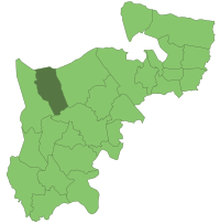
 Ruislip-Northwood within Middlesex in 1961 |
|
| Geography | |
| Status | Urban district |
| 1911/1931 area | 6,585 acres (26.6 km2) |
| 1961 area | 6,584 acres (26.6 km2) |
| HQ | Oaklands Gate |
| History | |
| Origin | Ruislip parish |
| Created | 1904 |
| Abolished | 1965 |
| Succeeded by | London Borough of Hillingdon |
Quick facts for kids Demography |
|
|---|---|
| 1911 population - 1911 density |
6,217 0.94/acre |
| 1931 population - 1931 density |
16,042 2.44/acre |
| 1961 population - 1961 density |
72,791 11.05/acre |
| Politics | |
| Governance | Ruislip-Northwood Urban District Council |
 |
|
Ruislip-Northwood was a special local government area called an urban district. It was located in west Middlesex, England. This district existed from 1904 until 1965.
From the very beginning, Ruislip-Northwood was part of the Metropolitan Police District. This meant it was policed by the same force as London. After 1933, it also became part of the London Passenger Transport Area. This helped people travel easily around London and its nearby areas.
The local council for the urban district saw a huge increase in people moving to the area. This happened because the Metropolitan Railway made it easy to build new homes and businesses. The council faced many challenges. They had to improve public services and housing. They also worked hard to protect the area's important historical sites.
In 1931, King's College, Cambridge sold its last pieces of land to the council. King's College had owned much of the land in Ruislip since the mid-1400s. The urban district was closed down in 1965. Its area then became part of the new London Borough of Hillingdon, which is part of Greater London.
Contents
History of Ruislip-Northwood
How the District Started
The Ruislip-Northwood urban district was created on September 30, 1904. It covered the area of Ruislip parish. Before this, Ruislip was part of the Uxbridge Rural District. The parish of Ruislip included places like Ruislip Manor, South Ruislip, Eastcote, and Northwood.
The new urban district council had its first meeting on October 1, 1904. It took place at Northwood School. The idea of forming an urban district council had been discussed a year earlier. This was because areas within the parish, especially Northwood, were growing quickly.
A report in 1903 showed that Northwood had 2,700 people and 530 houses. The rest of Ruislip parish was still mostly countryside. The meeting also talked about the Metropolitan Railway extending its line. A new train station was planned for Ruislip. King's College, Cambridge, which owned much of the land, planned to sell some for new buildings because of the railway. Because of these changes, the Ruislip Parish Council decided to become an urban district.
Council Governance and Area Growth
In 1904, the urban district council had nine councillors. William Page Edwards was the Chairman. Other members included F. M. Elgood and Rev. Harvey Roe. E. R. Abbot was hired as the clerk for £100 a year. He stayed in this job until 1931. By 1920, the number of councillors had grown to 15.
The expansion of the Metropolitan Railway led to a huge population boom. The number of people living there jumped from 6,217 in 1911 to 72,791 in 1961. This also caused a lot of new houses to be built, especially in the area known as Metro-land.
Because of this growth, Ruislip-Northwood was one of the first places in England to create a detailed planning scheme in 1914. This followed a new law called the Housing and Town Planning Act 1909. The council's Chairman, Mr. Elgood, and the Clerk, Mr. Abbot, encouraged this. Council members were already worried about some new buildings. They described new developments near Eastcote, South Ruislip, and Northwood station as "badly arranged and closely-packed."
The new council set up three main departments. These were Finance and General Purposes, Public Health, Buildings and Sewerage, and Highways. The council tried to save money from the start. They cut the number of road workers from ten to seven. They also stopped cleaning ditches next to the roads.
The council worked with King's College, Cambridge, to plan building plots around Ruislip and Ruislip Manor. They held a town planning competition. A & J Soutar, planners from Wandsworth, won. They wanted to create a balanced design across Ruislip parish. Many woods and historic places, like Manor Farm, were planned to be removed. This would make space for 7,642 homes, enough for 35,000 people. Only St. Martin's church in Ruislip would have been saved.
A map of the plan was shown to the public in November 1910. There were not many objections. A local inquiry followed in February 1911. This led to talks with landowners to create a full planning scheme. This plan was presented in February 1913. It was a changed version of the original Soutars plan. The Local Government Board approved it in September 1914.
Three residential roads were finished before the First World War started. These were Manor Way, Windmill Way, and Park Way. All building work stopped during the war. It did not start again until 1919. The Ruislip Manor Cottage Society was formed in 1911. Its goal was to build small houses and cottages. However, it did not build as many as planned. The council took over some land in Eastcote, so only four houses could be built there by the society. In Northwood, eighteen cottages were built later in 1926.
Growth After the First World War
Manor Farm and the local woods were eventually saved from new buildings in January 1930. This happened after a member of the Royal Society of Arts visited. They chose which buildings should be protected. The Great Barn and Little Barn were chosen. Also saved were the old Post Office, the Old Bell public house, and the Priest's House of the local church.
The woods were part of a sale by King's College, Cambridge, to the district in February 1931. Park Wood was sold for £27,300. Manor Farm and the old Post Office were given as a gift to the people of Ruislip. King's College wanted to give the wood as a gift too. But a university law required them to receive payment.
Middlesex County Council paid 75 percent of the cost. The urban district council argued that many people using the land would be day-trippers from outside the district. The council agreed to a 999-year lease. They promised to take care of the wood. They also agreed not to build anything new without the county council's permission. A small part of the wood to the south was not included in the lease. Three residential roads were later built there.
Copse Wood was bought by Middlesex County Council and London County Council in 1936 for £23,250. Mad Bess Wood was also bought in the same year. The urban district council bought the 186-acre wood with Middlesex and London County Councils. They paid £28,000 in a compulsory purchase from Sir Howard Stransom Button. Sir Howard became High Sheriff of Middlesex in 1937.
The council bought Haydon Hall and its 14.7 acres of land in 1936. They planned to build a civic center there. But the Second World War started in 1939. This plan was stopped and never continued.
During the war, the urban district was bombed many times by the Luftwaffe. This happened during The Blitz, from September 8, 1940, to May 9, 1941. There were 57 bombing raids recorded. These included 241 high explosive bombs, 2000 incendiary bombs, and 4 parachuted landmines. Sadly, 27 people were killed and 231 were injured.
A public hall was built on part of the Manor Farm site in 1965. It was named Winston Churchill Hall. The land for the hall was called Barn Close. Councillor T. R. Parker bought it in 1932 from King's College. He gave the land to the Ruislip Village Trust. The Trust then gave it to the urban district council in 1964. They said it must only be used for a public hall.
End of the Urban District
The urban district was closed down in 1965. Its area then became part of the London Borough of Hillingdon in Greater London. By this time, about 75,000 people lived in the district.
The name Ruislip-Northwood lived on in the local Member of Parliament area. This was called the Ruislip-Northwood parliamentary constituency. It existed until 2010. Then, it became part of the Ruislip, Northwood and Pinner constituency.
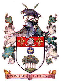
Coat of Arms
Ruislip-Northwood was given its own coat of arms in 1937. It had a shield with a picture of oak trees growing from a green hill. Above the trees was a blue circle with a gold five-pointed star. At the top of the shield, on a red band, there was a silver mitre (a bishop's hat) between two gold fleurs-de-lis (a lily symbol).
It also had a crest above the shield. This crest showed a black boar walking. It had gold tusks and hooves. In front of the boar were two crossed ears of rye.
The trees and the Pole Star on the shield were a clever way to show the name Northwood. The mitre and fleurs-de-lys refer to the Abbey of Bec Herlewin in Normandy. This Abbey once owned the land of Ruislip. Later, King Henry V took the Manor. He gave it to King's College, Cambridge. Both the Abbey and the college were dedicated to St. Mary. A fleur-de-lis is one of her symbols. The 'rye slips' were a play on the name Ruislip. The wild boar showed that the area was very old. It was given its name when the land was a forest where wild boars roamed.
Today, the coat of arms of the London Borough of Hillingdon uses parts of the old Ruislip-Northwood coat of arms. It includes the Pole Star, the fleur-de-lis, and the rye stalks.
 | Chris Smalls |
 | Fred Hampton |
 | Ralph Abernathy |


