Vaishali district facts for kids
Quick facts for kids
Vaishali district
|
|
|---|---|
|
District of Bihar
|
|

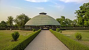
Relic Stupa in Vaishali
|
|
 |
|
| Country | |
| State | Bihar |
| Division | Tirhut |
| Established | 10 December 1972 |
| Headquarters | Hajipur |
| Area | |
| • Total | 2,036 km2 (786 sq mi) |
| Elevation | 51 m (167 ft) |
| Population
(2011)
|
|
| • Total | 3,495,021 |
| • Density | 1,716.6/km2 (4,446.0/sq mi) |
| Demographics | |
| • Literacy | 66.60% |
| • Sex ratio | 1.895 ♂/♀ |
| Language | |
| • Official | Hindi |
| • Additional official | Urdu |
| • Regional Languages | Maithili |
| Time zone | UTC+05:30 (IST) |
| PIN |
8441xx (Vaishali)
|
| Major highways | NH 22, NH 31, NH 322 |
| HDI (2016) | |
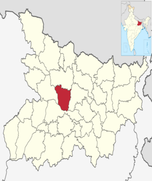
Vaishali district is a region in the Indian state of Bihar. It is part of the Tirhut division. Vaishali is famous for being the birthplace of Mahavira, a very important figure in the Jain religion.
Hajipur, the largest city and main office of the district, is well-known for its large banana farms. The district is connected to other major cities like Patna (the state capital) and Muzaffarpur by important roads and bridges over the Ganges River. These bridges include the Gandhi Setu and the Jay Prakash Setu.
Contents
History of Vaishali
Ancient Beginnings
The name Vaishali is believed to come from King Vishala. He was a son of Ikshvaku and is said to have founded the city. Long ago, Vaishali was the capital of the strong Licchavi republic. It played a big role in the early stories of both Buddhism and Jainism.
During that time, Vaishali was a very old and important city. It was the capital of the Vajji confederation, a group of republics in the Mithila area. This region covered much of what is now Bihar, near the Himalayas. Later, rulers from the Shishunaga dynasty even moved their capital from Pataliputra to Vaishali.
Modern District Formation
Vaishali became its own district in 1972. Before that, it was part of the Muzaffarpur district.
Geography and Area
The Vaishali district covers an area of about 2,036 square kilometers (786 square miles).
Economy and Development
In 2006, the Indian government recognized Vaishali as one of the country's "most backward districts." This means it needed extra help for development. It is one of the districts in Bihar that receives special funds from a program called the Backward Regions Grant Fund Programme (BRGF) to help it grow and improve.
People and Population
| Religions in Vaishali district (2011) | ||||
|---|---|---|---|---|
| Religion | Percent | |||
| Hinduism | 90.20% | |||
| Islam | 9.56% | |||
| Other or not Stated | 0.24% | |||
According to the 2011 census, Vaishali district has a population of 3,495,021 people. This is roughly the same as the country of Panama or the US state of Connecticut. This population size makes it the 86th largest district in India out of 640.
The district has about 1,717 people living per square kilometer. Between 2001 and 2011, the population grew by 28.58%. For every 1,000 males, there are 892 females. About 66.60% of the people in Vaishali can read and write. A small part of the population (6.67%) lives in cities.
Languages Spoken
In 2011, most people in Vaishali district spoke Hindi (95.09%) or Urdu (4.80%) as their first language. A local dialect called Bajjika is also spoken in the region. Some people consider Bajjika to be a form of the Maithili language.
Wildlife and Nature
In 1997, the Barela Salim Ali Zubba Saheni Wildlife Sanctuary was established in the district. This sanctuary covers an area of 2 square kilometers (0.77 square miles) and protects local wildlife.
How Vaishali is Governed
The Vaishali district is managed by a top government official called a District Magistrate (DM). This person is an IAS officer, which means they are part of the Indian Administrative Service.
The district has 1,414 villages, which are grouped into 290 local councils called Gram Panchayats. There are also 30 police stations that help keep the area safe.
Main Divisions (Tehsils)
Vaishali district is divided into three main parts, called Tehsils or Sub-divisions. Each of these is led by a Sub-Divisional Magistrate (SDM):
- Hajipur
- Mahnar
- Mahua
Smaller Divisions (Blocks)
These Tehsils are further divided into 16 smaller areas called Blocks. Each Block is managed by a Block Development Officer (BDO).
- Bhagwanpur
- Bidupur
- Chehra Kalan
- Desari
- Goraul
- Hajipur
- Jandaha
- Lalganj
- Mahnar
- Mahua
- Patedhi Belsar
- Patepur
- Raghopur
- Rajapakar
- Sahdei Buzurg
- Vaishali
More to Explore
- List of tehsils in Vaishali district
- List of villages in Vaishali district
- Vaishali (ancient city)
 | Bessie Coleman |
 | Spann Watson |
 | Jill E. Brown |
 | Sherman W. White |

