Van Sickle Island facts for kids

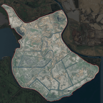
United States Geological Survey aerial imagery of Van Sickle Island
|
|
| Geography | |
|---|---|
| Location | Northern California |
| Coordinates | 38°04′00″N 121°54′04″W / 38.06667°N 121.90111°W |
| Adjacent bodies of water | Suisun Bay |
| Area | 10,000 acres (4,000 ha) |
| Highest elevation | 0 ft (0 m) |
| Administration | |
| State | |
| County | Solano |
| Demographics | |
| Population | 22 (2009) |
Van Sickle Island is a large island, about 10,000 acres, located in Suisun Bay, California. It is part of Solano County. A special group called Reclamation District 1607 helps manage the island. In 1981, the United States Geological Survey noted that the island is at sea level.
The island's land is divided into 22 private areas. These are mostly used for duck hunting clubs and private homes. In the past, a railroad bridge built in 1913 connected the island to Montezuma and Chipps Island. From Chipps Island, a ferry used to go to Mallard Island and Pittsburg. These connections are no longer used, and the old bridges are gone. Today, you can reach Van Sickle Island by boat. You can also get there by bridges from Hammond Island and Wheeler Island.
Contents
Island Location and Wildlife


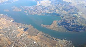
Van Sickle Island is found in Suisun Bay, which is a part of San Francisco Bay in Northern California. It sits on the eastern edge of Suisun Marsh. This area has many marsh islands, separated by small rivers and waterways called sloughs.
Van Sickle Island has about 2,400 acres of wetlands that are carefully managed. These wetlands are important for birds and other wildlife. Even though these areas are privately owned, they help protect the habitat for waterfowl and other animals.
The island has several neighbors. To the north is Hammond Island, across Roaring River Slough. Wheeler Island is to the northwest. Honker Bay, another part of Suisun Bay, is to the west. To the southwest is Chipps Island, across Spoonbill Creek. Suisun Bay borders the island to the south and southeast. Montezuma is to the east, across Montezuma Slough, and Spinner Island is to the northeast.
There are bridges connecting Van Sickle Island to its neighbors. One bridge links the island to Hammond Island. You can reach Hammond Island by car from the mainland. Two other bridges connect Van Sickle Island to Wheeler Island. On the eastern tip of Van Sickle Island, two roads connect to Spinner Island, which does not have mainland road access.
In 2009, 22 people lived on Van Sickle Island. The island was divided into 22 separate areas. By 2017, it was home to around 20 duck hunting clubs. A report from 2009 said that there were no plans for the island to grow or develop.
Island History
Like many islands in Suisun Bay and the Sacramento–San Joaquin River Delta, Van Sickle Island was created in the mid-1800s. Workers used machines to dig out sloughs and build up walls of earth called levees. This process is called land reclamation. Once the levees were built, the water inside was drained. This created large areas of rich land. This land was used for raising cattle and growing crops like beans and tule plants.
However, keeping the levees in good shape became very expensive. It got to the point where farming was no longer profitable. Because of this, the island slowly became a popular spot for waterfowl hunting and other fun activities.
Over time, the island has been known by different names. These include "Jones Island," "Van Sickle Island," "Van Sickles Island," and "Van Sickle's Island." On old maps from the 1850s, it was often called "Jones Island." But in 1891, a group called the Board on Geographic Names decided its official name would be Van Sickle Island.
Reclamation District 1607
In November 1914, a group called Reclamation District 1607 was created. Their job was to manage water drainage, irrigation, and keep the levees strong. Landowners on the island pay fees to help fund the district's work. A group of five people, called the Board of Trustees, runs the district. These trustees are elected by the landowners and serve for four years. They meet several times a year and are not paid for their work. The district also has two part-time employees who help with inspections and maintenance.
Today, the reclamation district gets most of its money from annual fees paid by landowners. They pay about $10 per acre each year. The district also receives money from other government groups, like the California Department of Water Resources. In 2008, the district made a deal with Venoco, a company that has natural gas wells on the island. Venoco pays $50,000 each year to use the island's levees for their equipment.
Levees and Flooding
Van Sickle Island is surrounded by 12 miles of levees. In 2009, there were three pumping stations on the island. These pumps remove water from the island. This happens either when the island is purposely flooded for waterfowl management, or when it floods by accident due to strong winds or high tides. One pump belongs to the Reclamation District, and two are privately owned.
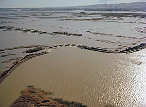
The levees on Van Sickle Island have been damaged and broken many times.
- In December 1983, broken levees caused floods across the Delta. Van Sickle Island was completely covered in water.
- In January 1997, big storms in California caused a major disaster. The Reclamation District asked for money to fix the levees, but their request was turned down.
- In January 2005, a winter storm brought strong winds and heavy rain. This caused a levee on Van Sickle Island to break on January 7.
- In January 2017, a very high tide, called a king tide, caused a lot of damage to levees in the Suisun Marsh. Van Sickle Island's levees were among the worst hit. A large section of the levee broke, and the island flooded within hours.
- In February 2019, water flowed over some levees, but it did not cause a major break.
The district continues to work on repairing and strengthening the levees to protect the island.
Old Railroad History
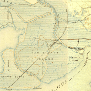
In 1913, a company called the Oakland, Antioch and Eastern railway built an electric train line from Oakland to Sacramento. They planned to build a bridge across Suisun Bay, but it never happened. Instead, they used a wooden ferry named "Bridgit" (later replaced by a steel ferry called "Ramon") to move trains between West Pittsburg and Chipps Island. From Chipps Island, trains crossed Van Sickle Island on a long wooden bridge to the Montezuma stop. This railway later became part of the Sacramento Northern Railway.
Passenger trains stopped running in 1941. Freight trains continued to use the route through Van Sickle Island until April 7, 1954, when the "Ramon" ferry was taken out of service. After that, trains to Sacramento took a different route. Today, most of the old Sacramento Northern railway tracks are no longer used, including those on Van Sickle Island. The rail bridges that connected the island to Montezuma and Chipps Island are also gone.
 | Mary Eliza Mahoney |
 | Susie King Taylor |
 | Ida Gray |
 | Eliza Ann Grier |


