
Var (department) facts for kids
Quick facts for kids
Var
|
|||
|---|---|---|---|

Place de la Liberté in Toulon
|
|||
|
|||

Location of Var in France
|
|||
| Country | France | ||
| Region | Provence-Alpes-Côte d'Azur | ||
| Département | 4 March 1790 | ||
| Prefecture | Toulon | ||
| Subprefectures | Brignoles, Draguignan | ||
| Area | |||
| • Total | 5,972.5 km2 (2,306.0 sq mi) | ||
| Population
(2014)
|
|||
| • Total | 1,038,212 | ||
| • Density | 173.8321/km2 (450.223/sq mi) | ||
| Demonym(s) | Varois | ||
| Time zone | UTC+1 (CET) | ||
| • Summer (DST) | UTC+2 (CEST) | ||
| ISO 3166 code | FR-83 | ||
| Arrondissements | 3 | ||
| Cantons | 23 | ||
| Communes | 153 | ||
| Website | www.var.fr | ||


The Var is a special area in southeastern France. It's called a department. It's part of the Provence-Alpes-Côte d'Azur region in Provence.
The department gets its name from the Var river. This river used to flow along its eastern edge. But the border changed in 1860, so the river isn't in the department anymore!
The main city and capital of Var is Toulon.
Contents
History of Var
How Var Was Created
Var was one of the first 83 departments made during the French Revolution. This happened on March 4, 1790. At first, Toulon was its capital city. The department was formed from a part of the old area called Provence.
It was first divided into nine smaller areas called districts. These included Toulon, Grasse, and Draguignan.
Changes in Capital Cities
The capital city of Var moved several times!
- In 1793, it moved from Toulon to Grasse.
- In 1795, it moved from Grasse to Brignoles.
- In 1797, it moved again to Draguignan.
In 1800, the nine districts became four larger areas called arrondissements. These were Brignoles, Draguignan, Grasse, and Toulon.
Later Changes and World Wars
After a big battle called the Battle of Waterloo in 1815, the Var department was taken over by the Austrian army for a few years.
In 1860, the Grasse arrondissement became part of a new department called Alpes-Maritimes. This is why the Var river no longer flows through the Var department.
In 1926, the Brignoles arrondissement was removed. But in 1974, Brignoles became an arrondissement again. Also, the capital moved back to Toulon from Draguignan. Var is the only French department that has had four different capital cities: Toulon, Grasse, Brignoles, and Draguignan. Today, Toulon is the main capital, and Brignoles and Draguignan are smaller capital cities (subprefectures).
During World War II, the Var department was occupied by Italian forces from 1942 to 1943. Then, the German army took control in 1944.
Geography of Var
Where Var Is Located
Var is part of the Provence-Alpes-Côte d'Azur region. It covers an area of about 5,972.5 square kilometers (2,306 square miles).
The department shares borders with three other departments, all in the same region:
- To the east: Alpes-Maritimes
- To the north: Alpes-de-Haute-Provence
- To the west: Bouches-du-Rhône
It also has a very short border with the Vaucluse department to the northwest.
 |
Alpes-de-Haute-Provence | |
||
| Bouches-du-Rhône | Alpes-Maritimes | |||
| Mediterranean Sea |
Mountains and Islands
The highest point in Var is Mont de Lachens. It is about 500 to 505 meters (1,640 to 1,657 feet) high. This mountain is in the town of Mons, close to the border with the Alpes-Maritimes department.
The Îles d'Hyères are a group of three islands off the coast near Hyères. Their names are Porquerolles, Port-Cros, and Île du Levant. Together, these islands cover about 26 square kilometers (10 square miles). You can reach them by boat from Hyères or Toulon.
Climate in Var
The climate in Toulon, a major city in Var, is a "Mediterranean climate". This means it has hot, dry summers and mild, wet winters.
On average, Toulon gets about 678.2 millimeters (26.7 inches) of rain each year. November is usually the wettest month, while July is the driest.
The average temperature in Toulon for the whole year is about 16.1°C (61°F). July is the warmest month, with an average of 23.9°C (75°F). January is the coolest, with an average of 9.4°C (49°F).
| Climate data for Toulon, France | |||||||||||||
|---|---|---|---|---|---|---|---|---|---|---|---|---|---|
| Month | Jan | Feb | Mar | Apr | May | Jun | Jul | Aug | Sep | Oct | Nov | Dec | Year |
| Mean daily maximum °C (°F) | 12 (54) |
12 (54) |
14 (57) |
16 (61) |
20 (68) |
24 (75) |
28 (82) |
28 (82) |
25 (77) |
20 (68) |
15 (59) |
13 (55) |
19 (66) |
| Daily mean °C (°F) | 9 (48) |
10 (50) |
11 (52) |
13 (55) |
17 (63) |
20 (68) |
23 (73) |
23 (73) |
21 (70) |
17 (63) |
12 (54) |
10 (50) |
16 (60) |
| Mean daily minimum °C (°F) | 6 (43) |
6 (43) |
8 (46) |
10 (50) |
13 (55) |
16 (61) |
19 (66) |
19 (66) |
17 (63) |
13 (55) |
9 (48) |
7 (45) |
12 (53) |
| Average rainfall mm (inches) | 60 (2.4) |
60 (2.4) |
60 (2.4) |
40 (1.6) |
40 (1.6) |
20 (0.8) |
— | 20 (0.8) |
50 (2.0) |
80 (3.1) |
80 (3.1) |
70 (2.8) |
670 (26.4) |
| Source: Weatherbase.com [1] | |||||||||||||
How Var Is Governed
Var is run by the Departmental Council of Ardennes, which is based in Toulon. This council helps manage the department. Var is part of the larger Provence-Alpes-Côte d'Azur region.
Divisions of Var
The Var department is divided into smaller parts to help manage it.
- There are 3 main areas called arrondissements (districts).
- These districts are further divided into 23 cantons.
- Inside these cantons, there are 153 communes (towns or municipalities).
Here's a look at the arrondissements in Var:
| INSEE code |
Arrondissement | Capital | Population (2014) |
Area (km²) |
Density (Inh./km²) |
Communes |
|---|---|---|---|---|---|---|
| 831 | Draguignan | Draguignan | 321,569 | 2,416.5 | 133.1 | 54 |
| 832 | Toulon | Toulon | 565,669 | 1,295.8 | 436.5 | 32 |
| 833 | Brignoles | Brignoles | 150,974 | 2,260.2 | 66.8 | 67 |
Here are the 23 cantons of the Var department, after changes made in March 2015:
- Brignoles (8301)
- La Crau (8302)
- Draguignan (8303)
- Flayosc (8304)
- Fréjus (8305)
- La Garde (8306)
- Garéoult (8307)
- Hyères (8308)
- Le Luc (8309)
- Ollioules (8310)
- Roquebrune-sur-Argens (8311)
- Saint-Cyr-sur-Mer (8312)
- Sainte-Maxime (8313)
- Saint-Maximin-la-Sainte-Baume (8314)
- Saint-Raphaël (8315)
- La Seyne-sur-Mer-1 (8316)
- La Seyne-sur-Mer-2 (8317)
- Solliès-Pont (8318)
- Toulon-1 (8319)
- Toulon-2 (8320)
- Toulon-3 (8321)
- Toulon-4 (8322)
- Vidauban (8323)
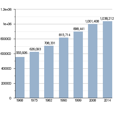
Population of Var
Who Lives in Var?
The people who live in the Var department are called Varois (if they are male) or Varoises (if they are female) in French.
In 2014, Var had a population of 1,038,212 people. This means there were about 173.8 people living in each square kilometer. The arrondissement of Toulon has the most people, with 565,669 inhabitants.
Population Changes Over Time
The number of people living in Var has grown a lot over the years. This chart shows how the population has changed:
Evolution of the population in Var
Biggest Towns in Var
Here are the towns (communes) in the Var department with the most people, based on 2014 data:
| City | Population (2014) |
Arrondissement |
|---|---|---|
| Toulon | 165,584 | Toulon |
| La Seyne-sur-Mer | 64,675 | Toulon |
| Hyères | 56,502 | Toulon |
| Fréjus | 53,511 | Draguignan |
| Draguignan | 40,054 | Draguignan |
| Saint-Raphaël | 34,567 | Draguignan |
| Six-Fours-les-Plages | 33,652 | Toulon |
| La Garde | 25,145 | Toulon |
| La Valette-du-Var | 22,271 | Toulon |
| La Crau | 16,749 | Toulon |
| Brignoles | 16,690 | Brignoles |
Gallery
-
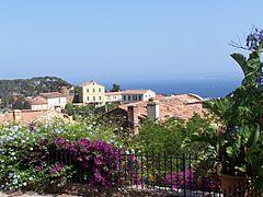
Bormes-les-Mimosas
-
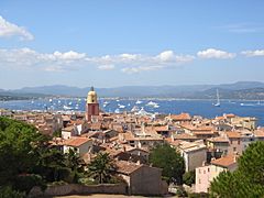
The Vieux Port of Saint-Tropez
-
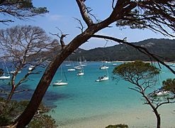
The beach of la Courtade in the Iles d'Hyeres.
-
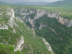
The Verdon Gorge


Related pages
Images for kids
-

Toulon, the historical capital city of Var, was returned that title in 1974.
-
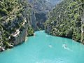
Verdon Gorge


See also
 In Spanish: Var para niños
