
Vechigen facts for kids
Quick facts for kids
Vechigen
|
||
|---|---|---|
 |
||
|
||

Vechigen
Location in Switzerland

Vechigen
Location in Canton of Bern
|
||
| Country | Switzerland | |
| Canton | Bern | |
| District | Bern-Mittelland | |
| Area | ||
| • Total | 24.82 km2 (9.58 sq mi) | |
| Elevation | 583 m (1,913 ft) | |
| Population
(Dec 2020 )
|
||
| • Total | 5,512 | |
| • Density | 222.08/km2 (575.18/sq mi) | |
| Postal code |
3067
|
|
| Surrounded by | Bolligen, Hasle bei Burgdorf, Krauchthal, Muri bei Bern, Oberburg, Stettlen, Walkringen, Worb | |

Vechigen is a town in Switzerland, located in the Bern-Mittelland area of the Bern region. It's a municipality, which means it's like a local government area. For a long time, until 1966, Vechigen was made up of four smaller, almost independent communities. These were Vechigen itself, Sinneringen (with Boll and Dentenberg), Utzigen (with Lindental), and Berg (with Littewil and Radelfingen).
Contents
History of Vechigen
Vechigen was first written about in history books in 1275. Other parts of the area, like Sinneringen and Utzigen, were also mentioned around the same time.
Early History of Vechigen
The Vechigen valley and its mountain used to belong to a noble family called the Baron of Belp-Montenach. But in 1298, the growing city of Bern took over their land. From then on, Vechigen became one of the four main church areas (called parishes) outside of Bern. People living in Vechigen were also considered citizens of Bern until 1798.
The local church, dedicated to St. Martin, was first mentioned in 1275. It was rebuilt in 1513 and 1514, and its bell tower was built even earlier, in 1486.
In 1834, the modern municipality of Vechigen was officially created. It still had its four main parts: Vechigen, Sinneringen (with Boll and Dentenberg), Utzigen (with Lindental), and Berg (with Littewil and Radelfingen). Each part managed its own local things, like schools and roads. But the main municipality handled taxes and money for everyone.
In 1913, a train line called the Worblentalbahn opened a station in Boll-Utzigen. By the 1950s, the city of Bern started to grow bigger and spread out along this train line. The villages of Boll and Sinneringen became part of this growing city area. Their populations grew very fast, while other parts of Vechigen stayed the same or even got smaller.
As these areas changed from farms to places where people lived and commuted, the old way of governing became difficult. So, in 1966, the local government was made into one single system. A secondary school was built in Vechigen in 1961, and now there are five school buildings in total.
Sinneringen and Boll: Growing Villages
Before 1966, the Sinneringen area included Sinneringen itself, plus smaller villages (called hamlets) like Boll and Dentenberg. It also had farmhouses in the Worblen Valley and on Dentenberg Mountain.
Archaeologists found old graves from the Hallstatt culture (an ancient time) on a hillside above the Worblen. They also found the remains of a Roman villa at a place called Hubel. In the 13th century, powerful leaders called Counts of Kyburg were in charge of the village. In 1729, a man named Hans Rudolf von Diesbach built a country house, known as the Schlössli, in Sinneringen. Later, in 1844, an artist named August von Bonstetten made the house bigger and added a clock tower.
By the 1950s, Sinneringen became part of the growing Bern city area, and its population quickly increased. By 2005, more than half of all the people in Vechigen lived in Sinneringen and Boll.
Boll started as a place with shops and inns where two important roads met. In the 1700s and 1800s, it had a customs station (where taxes were collected), an inn, a blacksmith, a sawmill, and a few houses. Over time, nearby rivers were moved, and swamps were drained. This created new land for homes and farms around Boll. Even with new roads and a train station in 1913, Boll stayed a small village. But in the 1960s, as Bern grew, Boll also expanded quickly. Today, most people living in Boll travel to Bern for work.
Utzigen: From Castle to Care Home
The Utzigen area included the village of Utzigen, the hamlets of Wuhl, Birchi, and Lindental, and about 50 houses on a hillside. Utzigen began as a special territory ruled by a lord in the Late Middle Ages. From the 1300s, different wealthy families from Bern owned it. They managed the area from Utzigen Castle.
In 1669, Samuel Jenner built a new castle where the old one stood. After the French invaded Switzerland in 1798, the special ruling rights of the castle were ended. The family who owned the castle at that time, the Dachselhofers, lost their power to hold local courts. However, they kept the castle and their other property. The castle was their summer home until 1875.
Then, the municipality bought the castle. They turned it into a place for people who struggled with alcohol or who didn't have jobs. At one point, over 500 people lived there and worked on the large farm. In 1964, the castle became a nursing and retirement home. In 2001, it changed again to a residential care home. The village of Utzigen also has a primary school for younger students.
Geography of Vechigen
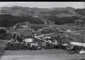
Vechigen is about 10 kilometers (6 miles) east of the city of Bern. It's a pretty town, a bit off the main roads, and is known for its beautiful scenery. The highest point in Vechigen is a spot called Schönbrunnenchnubel, which is 956 meters (3,136 feet) high. The lowest point is the Worble river, at 550 meters (1,804 feet).
Vechigen covers an area of 25 square kilometers (9.65 square miles). A large part of this land, about 60.7%, is used for farming. Forests cover about 30.4% of the area. The rest of the land, about 8.5%, has buildings or roads. A very small part, 0.2%, is covered by rivers or lakes.
In the areas with buildings, homes and other structures take up 5.6% of the land. Roads and other transport areas make up 2.6%. Most of the forested land is dense forest (29.2% of the total area). The farmland is used for growing crops (35.6%), pastures for animals (23.1%), and fruit trees (2.0%). All the water in Vechigen is from flowing rivers and streams.
The municipality is located in the upper part of the Worblental (Worblen valley). It includes the main villages of Vechigen, Sinneringen, and Boll in the valley. Utzigen is on the mountain slopes. There are also many smaller villages and farmhouses spread out, like Lindental, Littewil, Radelfingen, and Dentenberg.
On December 31, 2009, Vechigen's old administrative area was closed. The next day, January 1, 2010, it became part of the new Bern-Mittelland administrative district.
Coat of Arms
The coat of arms for Vechigen is red with a silver wing on it.
Population and People
As of December 2020, Vechigen had a population of 5,512 people. About 6.8% of these people were foreign nationals in 2010. Between 2000 and 2010, the population grew by 4.4%. Most of this growth (3.8%) was from people moving into Vechigen, and a smaller part (0.6%) was from more births than deaths.
In 2000, most people in Vechigen (95.7%) spoke German as their main language. French was the second most common language (0.9%), followed by English (0.9%).
In 2008, about 49.1% of the population was male and 50.9% was female. Most people (about 73.3%) were born in Switzerland. About 27.9% of the people living in Vechigen in 2000 were also born there.
In 2010, children and teenagers (ages 0-19) made up 21.2% of the population. Adults (ages 20-64) were 59.1%, and seniors (over 64) were 19.7%.
Interesting Places to See
The entire small village area of Lindental is recognized as an important Swiss heritage site. This means it has special historical or cultural value.
Economy and Jobs
In 2011, Vechigen had a low unemployment rate of 1.01%. In 2008, there were 1,159 people working in the municipality.
- Primary Sector: About 299 people worked in the primary sector, which includes farming. There were about 105 businesses in this area.
- Secondary Sector: About 166 people worked in the secondary sector, which includes manufacturing and construction. There were 37 businesses in this area.
- Tertiary Sector: About 694 people worked in the tertiary sector, which includes services like sales, healthcare, and education. There were 94 businesses in this area.
In 2000, 402 workers came into Vechigen for work, while 1,654 residents left Vechigen to work elsewhere. This means more people leave Vechigen for work than come in. About 27.1% of working people used public transportation to get to work, and 48.5% used a private car.
Religion
Based on the 2000 census, about 10.3% of the people in Vechigen were Roman Catholic. A larger group, about 74.7%, belonged to the Swiss Reformed Church. Other people belonged to various Christian churches, or other religions like Islam, Buddhism, or Hinduism. About 6.63% of the people said they had no religious beliefs.
Education in Vechigen
In Vechigen, about 39.7% of the people have finished non-mandatory upper secondary education. This is like high school or vocational training. About 17.7% have gone on to higher education, like a university or a specialized college.
The school system in the Bern region starts with one year of optional kindergarten. After that, students go to six years of primary school. Then, they have three years of compulsory lower secondary school. In secondary school, students are grouped based on their skills. After lower secondary school, students can choose to continue their education or start an apprenticeship (learning a trade on the job).
During the 2009-2010 school year, 482 students attended schools in Vechigen. There were four kindergarten classes with 62 students. At the primary level, there were 16 classes with 296 students. For lower secondary school, there were eight classes with 124 students.
In 2000, 19 students came to Vechigen from other towns to go to school. At the same time, 209 students from Vechigen went to schools outside the municipality.
See also
 In Spanish: Vechigen para niños
