
Walkringen facts for kids
Quick facts for kids
Walkringen
|
||
|---|---|---|

Eurythmy hall in Rüttihubelbad hamlet in Walkringen municipality
|
||
|
||

Walkringen
Location in Switzerland

Walkringen
Location in Canton of Bern
|
||
| Country | Switzerland | |
| Canton | Bern | |
| District | Bern-Mittelland | |
| Area | ||
| • Total | 17.21 km2 (6.64 sq mi) | |
| Elevation | 708 m (2,323 ft) | |
| Population
(Dec 2020 )
|
||
| • Total | 1,755 | |
| • Density | 101.98/km2 (264.12/sq mi) | |
| Postal code |
3512
|
|
| Surrounded by | Arni, Biglen, Hasle bei Burgdorf, Landiswil, Lützelflüh, Vechigen, Worb | |

Walkringen is a small town, also called a municipality, located in the Bern-Mittelland area in the canton of Bern, Switzerland. It's a peaceful place with a rich history.
Contents
A Look at Walkringen's Past

Walkringen was first mentioned in old records in the year 1220. Back then, it was known as Walcheringin.
Scientists have found signs of very old settlements here. For example, Bronze Age tools and items were discovered in the Walkringen Bog. There are also bricks from the Roman times and old forts from the Middle Ages. These forts, found on hills like Adlisberg, show that powerful families once ruled this area.
The three villages that make up Walkringen today – Walkringen, Wikartswil, and Bigenthal – have been joined and separated many times over the years. In the 1200s, a family called the Lords of Kien controlled these villages and their church. Later, in 1398, a noblewoman named Verena von Seedorf gave Walkringen village and its church to Thorberg Abbey. An abbey is like a monastery for monks or nuns.
The Abbey created a church district, called a parish, in Walkringen between 1413 and 1418. But in 1528, the city of Bern changed its religion to Protestantism. This meant Thorberg Abbey and its lands, including Walkringen, became part of the government's control. Walkringen village was then managed by Bern's local officer, called a bailiff. The three villages stayed separate until the 1800s, when they finally joined together to form one municipality.
The first church in Walkringen was likely built around the 800s. However, the cemetery was used even earlier, in the 600s. A new church was built on the old one's foundations and was first mentioned in 1239. The church building you see today was built in 1514-1515.
For a long time, people in Walkringen mostly worked as farmers. The village was on an important road between the Aare and Emme valleys. In 1507, the Bern government even built a toll station here to collect money from travelers. In the 1700s and 1800s, this road helped Walkringen become a center for making canvas fabric.
When the fabric industry slowed down, sawmills and other businesses moved in. Over the years, the wet, marshy lands (bogs) were drained in 1848 and again in 1944. This created more land for farming. In 1899, a train station opened on the line between Burgdorf and Thun. Today, Walkringen is a local hub with places like the Friederika Foundation, which helps people with job training, and a nursing home. All three villages – Walkringen, Wikartswil, and Bigenthal – have school buildings.
Walkringen's Landscape

Walkringen covers an area of about 17.2 square kilometers (6.6 square miles). A large part of this land, about 55.1%, is used for farming. Forests cover about 37.2% of the area. The rest of the land, about 7.5%, has buildings or roads. A very small part, about 0.2%, is made up of rivers or lakes.
Most of the forested land is dense forest, and a small part has orchards or groups of trees. For farming, about 20.2% of the land is used for growing crops, and 32.2% is used for pastures where animals graze. All the water in Walkringen is flowing water, like rivers and streams.
The municipality is located in the upper valley of the Bigen river. It includes the main villages of Walkringen, Bigenthal, and Wikartswil. It also has smaller settlements called hamlets, like Schwendi and Wydimatt, along with many scattered farmhouses.
In 2010, Walkringen became part of a new administrative district called Verwaltungskreis Bern-Mittelland.
Walkringen's Coat of Arms
The blazon (description) of Walkringen's municipal coat of arms is: Barry dancetty of six Gules and Argent. This means it has six wavy horizontal stripes, alternating between red (Gules) and silver (Argent).
Who Lives in Walkringen?
Walkringen has a population of about 1,817 people (as of December 2011). A small part of the population, about 4%, are people from other countries.
Most people in Walkringen, about 97.1%, speak German as their first language. A small number of people also speak African languages or Serbo-Croatian. There are also a few people who speak French, Italian, or Romansh.
In 2008, about 49.1% of the population was male and 50.9% was female. Most people living in Walkringen were born either in the municipality itself or in the same canton (Bern).
Young people, aged 0–19, make up about 21.3% of the population. Adults aged 20–64 make up 60%, and seniors (over 64) make up 18.7%.
Many people in Walkringen are married. In 2000, about 38% of the people were born in Walkringen and still lived there.
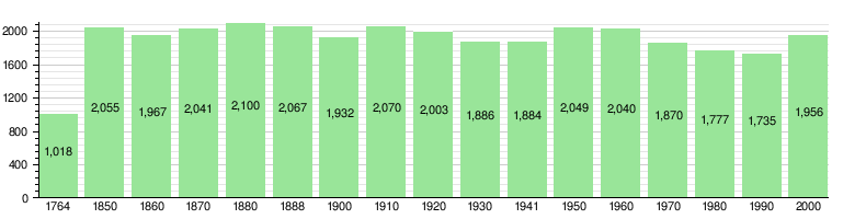
The number of people living in Walkringen has changed over time, as shown in the chart below:
Walkringen's Economy

In 2011, Walkringen had a very low unemployment rate of 0.95%. This means almost everyone who wanted a job had one.
In 2008, there were 985 people working in Walkringen.
- About 204 people worked in the primary sector, which includes farming.
- About 217 people worked in the secondary sector, like manufacturing and construction.
- About 564 people worked in the tertiary sector, which includes services like shops, restaurants, and healthcare.
Many people who live in Walkringen also work there. In 2000, about 419 people both lived and worked in the municipality. However, more people leave Walkringen to work elsewhere than come into Walkringen for work.
When it comes to getting to work, about 12% of people use public transportation, and about 54.7% use a private car.
Religion in Walkringen
Based on a 2000 survey, most people in Walkringen, about 80.6%, belong to the Swiss Reformed Church (a type of Protestant church). About 5.6% are Roman Catholic. A small number of people belong to other Christian churches, or are Islamic. About 5.8% of the population do not belong to any church.
Education in Walkringen
In Walkringen, about 53.6% of adults have finished high school (non-mandatory upper secondary education). About 16.9% have gone on to higher education, like university or a specialized college.
The school system in the Canton of Bern starts with one year of optional Kindergarten. After that, students go to six years of Primary school. Then, they have three years of lower Secondary school, where students are grouped by their abilities. After lower Secondary, students can choose to continue their education or start an apprenticeship (on-the-job training).
During the 2011-2012 school year, 174 students attended schools in Walkringen. There were 25 kindergarten students and 121 primary school students. There were also 28 students in lower secondary school.
Most students who live in Walkringen also go to school there. In 2000, 139 students both lived and attended school in the municipality. However, 139 other students from Walkringen went to schools outside the municipality.
Getting Around Walkringen
Walkringen has two train stations: Walkringen and Bigenthal. These stations are on the Burgdorf–Thun line. You can catch trains from here to places like Thun, Konolfingen, and Solothurn.
See also
 In Spanish: Walkringen para niños
