Vercors Massif facts for kids
Quick facts for kids Vercors |
|
|---|---|
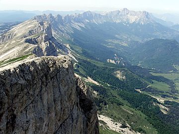
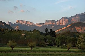
The view to the north of Le Grand Veymont
|
|
| Highest point | |
| Peak | Grand Veymont |
| Elevation | 2,341 m (7,680 ft) |
| Dimensions | |
| Length | 60 km (37 mi) North |
| Width | 40 km (25 mi) West |
| Area | 1,350 km2 (520 sq mi) |
| Geography | |
| Country | France |
| Region | Rhône-Alpes |
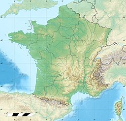
| Range coordinates | 44°58′N 5°25′E / 44.967°N 5.417°E |
| Parent range | Alps |
The Vercors Massif is a mountain range in France. It has rugged plateaus and mountains. It is located in the French Prealps, across the regions of Isère and Drôme. The Vercors Massif sits west of the Dauphiné Alps. The Drac and Isère rivers separate it from these Alps. The high cliffs on its eastern side face the city of Grenoble.
Contents
About the Vercors Massif
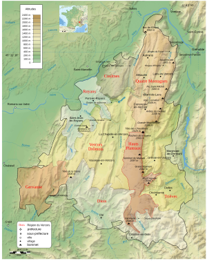
The Vercors has many different types of land. These include the Quatre Montagnes (Four Mountains) and the Coulmes (gorges). There are also the Vercors Drômois and the Hauts-Plateaux (high plateaus). Lower areas include Royans, Gervanne, Diois, and Trièves.
People sometimes call the massif "the fortress." This is because it is hard to travel between its different parts. Most travel happens between the massif and the flat lands around it.
Before the mid-1900s, the name Vercors only meant a small area. This included the town of La Chapelle-en-Vercors and the northern parts. These northern areas were around Lans-en-Vercors, Villard-de-Lans, Autrans, and Méaudre. This northern part was known as the Four Mountains area.
Vercors in World War II
In 1944, the Vercors Massif became very important during World War II. A group called the Maquis du Vercors set up a base here. They were part of the French Resistance fighting against German occupation. They even created a short-lived Free Republic of Vercors.
Caves and Outdoor Activities
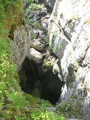
The Vercors has the biggest alpine karst area in the Northern French Pre-Alps. A karst area is where water has dissolved rock, creating caves. The Vercors has many large and deep cave systems. One famous cave is Gouffre Berger, which is over 1,100 meters (3,600 feet) deep. The Réseau de Coufin-Chevaline (Grotte de Choranche) is a show cave. It has almost 30 kilometers (19 miles) of mapped passages.
The Vercors is also a great place for sports. It has several resorts for cross-country skiing and downhill skiing. Villard-de-Lans is the largest downhill ski resort.
Nature and Wildlife
This beautiful area is protected to keep its natural environment safe. People have changed the land for farming and forests over time. But there are plans to plant more trees. This will make it one of the biggest forests in Metropolitan France. It will also be a safe home for many animals and plants. These include the southern tulip and black grouse. These two are symbols of the park. Other animals like the re-introduced griffon vulture and the alpine ibex also live here. The Vercors has many different climates and heights. This means it has a wide variety of plants and animals.
Where Does the Name Vercors Come From?
The name Massif du Vercors comes from an old tribe. This tribe lived in the area when the Roman conquest of Gaul happened. They were called the Vertamocorii. This name means excellent troops or troops of the summit. Today, people who live here are called Vertacomiriens.
Before the 1900s, the name Vercors only referred to the upper valleys of the Vernaison river. This was near the town of La Chapelle-en-Vercors. In the early 20th century, a man named Henri Ferrand explored the massif. He took many photos and wrote books about the mountains. He was the first to use the name Vercors for the whole area we know today. Other geographers, Raoul Blanchard and Jules Blache, made the name popular in the 1920s and 1930s. By the 1950s, everyone used the term.
Geography of Vercors
Location and Size
The Vercors Massif is in the Prealps in southeast France. It covers parts of the Drôme and Isère regions. These are both in the Rhône-Alpes area. It is about 100 kilometers (62 miles) southeast of Lyon. The massif covers 1,350 square kilometers (520 square miles). It is about 60 kilometers (37 miles) long from north to south. It is about 40 kilometers (25 miles) wide from east to west.
The Vercors is surrounded by other mountain ranges. To the north are the Chartreuse Mountains. To the east is the Matheysine area of the Dauphiné Alps. To the south is the Diois Massif. In the far southeast, it connects to the col de Menée, a mountain pass.
Rivers drain the massif. The Isère river drains the northeast and northwest. The Drac river drains the east. The Drôme river drains the south. The western side of the massif looks over the Rhône Valley.
Shape of the Land
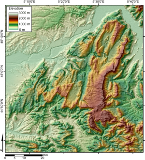
The Vercors Massif is known as the fortress or the French Dolomites. This is because of its unique shape. It looks like a high plateau. The drop from the massif to its inner valleys is a few hundred meters. But the drop to the surrounding flat areas is much bigger, between 800 and 1,200 meters (2,600 and 3,900 feet).
The eastern edge has several peaks over 2,000 meters (6,600 feet). The inside of the massif is lower, between 800 and 1,500 meters (2,600 and 4,900 feet). The Vercors also has wide valleys. These include the valley of Lans-en-Vercors and the areas around Autrans and La Chapelle-en-Vercors. There are also plateaus like forêt des Coulmes and forêt de Lente.
Deep gorges cut through the land, like the Bourne and Furon Gorges. These have huge cliffs, often over 400 meters (1,300 feet) high. Famous examples are the Combe Laval and the Cirque d'Archiane.
Mont Aiguille stands alone from the rest of the massif. This happened because of erosion over time. Some parts of the massif are hard to reach. For example, to get to Gresse-en-Vercors in the south, you might have to travel 100 kilometers (62 miles). This trip goes over the col de Rousset. Or you might travel 70 kilometers (43 miles) via Saint-Nizier-du-Moucherotte in the north.
Regions of Vercors
The central part of the Vercors Massif is split into several areas:
- The Coulmes are in the northwest. They are covered in thick forests. The rounded limestone hills make this area look very mountainous.
- The Four Mountains area is popular for tourism and skiing. But it also keeps its old traditions. These include raising dairy cows and making cheese. The main villages are Autrans, Méaudre, Lans-en-Vercors, and Villard-de-Lans. They are on two plateaus with wooded hills.
- The Drômois Vercors has many smaller plateaus. In the north, there are deep gorges with roads cut into the cliffs. Grassy areas are used for grazing animals in summer. The movement of animals between summer and winter pastures is a big celebration for the people of Die.
- The Haut-Plateaux (high plateaus) are the highest wilderness areas. This area is managed, and its pastures are used for grazing in summer.
The Vercors regional park also includes four areas on the edges of the massif:
- The Royans are the northwestern foothills. This is where walnuts grow. Three valleys lead to the Royans: the Gorges de la Bourne, the cirque of the Combe Laval, and the Échevis valley.
- The Gervanne is in the southwest. It is a rugged area of hills at the foot of the plateau. It has charming villages and looks towards Crest.
- The Diois is part of the Drôme valley around Die. This region feels like the Mediterranean. It has vineyards and fields of lavender.
- The Trièves is in the east. It is a low, hilly plateau. It lies between the highest peaks of the Vercors and the gorge made by the Drac river.
Main Peaks
Here are some of the main mountain peaks in the Vercors, from north to south:
- Le Moucherotte, 1,901 m (6,237 ft). This peak overlooks Grenoble.
- Le Pic Saint-Michel, 1,966 m (6,450 ft).
- Roc Cornafion, 2,049 m (6,722 ft).
- Les Arêtes du Gerbier, 2,109 m (6,919 ft).
- La Grande Moucherolle, 2,284 m (7,493 ft).
- La Petite Moucherolle, 2,156 m (7,073 ft).
- La Tête des Chaudières, 2,029 m (6,657 ft).
- Les Rochers de la Balme, 2,063 m (6,768 ft).
- Le Sommet de Malaval, 2,097 m (6,880 ft).
- Le Grand Veymont, 2,341 m (7,680 ft). This is the highest point of the massif.
- Le Mont Aiguille, 2,087 m (6,847 ft). It has a very unique shape. Its first climb in 1492 is seen as the start of alpinism (mountain climbing).
- Le Dôme or Pié Ferré, 2,041 m (6,696 ft). This is east of Die.
Main Road Passes
Here are some of the main road passes (cols) in the Vercors, from highest to lowest:
- Col du Mont Noir, 1,421 m (4,662 ft).
- Col de l'Allimas, 1,352 m (4,436 ft).
- Col de la Chau, 1,337 m (4,386 ft).
- Col de la Bataille, 1,313 m (4,308 ft).
- Col de Rousset, 1,254 m (4,114 ft) (tunnel height).
- Col de Saint-Alexis, 1,222 m (4,009 ft).
- Col de la Croix-Perrin, 1,218 m (3,996 ft).
- Col de Carri, 1,202 m (3,944 ft).
- Col de la Portette, 1,175 m (3,855 ft).
- Col de l'Arzelier, 1,154 m (3,786 ft).
- Col de Tourniol, 1,145 m (3,757 ft).
- Col de Proncel, 1,100 m (3,609 ft).
- Col des Limouches, 1,086 m (3,563 ft).
- Col de Romeyère, 1,069 m (3,507 ft).
- Col de la Machine, 1,011 m (3,317 ft).
The Tunnel du Mortier connected Montaud with Autrans. It was at 1,391 meters (4,564 feet) high. It closed in 1992 after a large landslide.
Main Caves
Here are some of the main caves in the Vercors. The town where the cave is located is in italics.
- Réseau du Gouffre Berger, d'Engins en Isère. It is 31,790 meters (104,300 ft) long and 1,271 meters (4,170 ft) deep.
- Réseau du Trou qui souffle, Autrans-Méaudre en Vercors. It is 42,900 meters (140,700 ft) long and 670 meters (2,200 ft) deep.
- Réseau du Clot d'Aspres, Villard-de-Lans. It is 42,000 meters (138,000 ft) long and 1,066 meters (3,497 ft) deep.
- Réseau de Coufin-Chevaline, Choranche. It is 29,839 meters (97,897 ft) long and 411 meters (1,348 ft) deep.
- Grotte de Gournier, Choranche. It is 18,000 meters (59,000 ft) long and 680 meters (2,230 ft) deep.
- Antre des Damnés, Corrençon-en-Vercors. It is 5,000 meters (16,000 ft) long and 865 meters (2,838 ft) deep.
- Grotte de la Luire, Saint-Agnan-en-Vercors. It is 37,563 meters (123,238 ft) long and 547 meters (1,795 ft) deep.
- Réseau des Chuats, Bouvante. It is 42,000 meters (138,000 ft) long.
The Grotte de Bournillon has the highest cave opening in Europe. It is 105 meters (344 ft) high.
Climate in Vercors
The Vercors has a much colder climate than the lowlands around it. This is because it is at a higher elevation. The village of La-Chapelle-en-Vercors is in the center of the massif. It has cold winters and warm summers. It also gets a lot of rain or snow all year round.
| Climate data for La Chapelle-en-Vercors, France. Coordinates: 44.971°N 5.419°E. Elevation: 2,948 feet (899 m). | |||||||||||||
|---|---|---|---|---|---|---|---|---|---|---|---|---|---|
| Month | Jan | Feb | Mar | Apr | May | Jun | Jul | Aug | Sep | Oct | Nov | Dec | Year |
| Mean daily maximum °C (°F) | 3.2 (37.8) |
4.6 (40.3) |
9.3 (48.7) |
12.4 (54.3) |
16.4 (61.5) |
20.2 (68.4) |
23.0 (73.4) |
22.4 (72.3) |
19.0 (66.2) |
13.4 (56.1) |
7.9 (46.2) |
3.8 (38.8) |
13.0 (55.3) |
| Daily mean °C (°F) | −0.6 (30.9) |
0.4 (32.7) |
4.3 (39.7) |
7.3 (45.1) |
11.0 (51.8) |
14.6 (58.3) |
16.9 (62.4) |
16.5 (61.7) |
13.7 (56.7) |
8.7 (47.7) |
4.2 (39.6) |
0.3 (32.5) |
8.1 (46.6) |
| Mean daily minimum °C (°F) | −4.3 (24.3) |
−3.8 (25.2) |
−0.6 (30.9) |
2.2 (36.0) |
5.7 (42.3) |
9.0 (48.2) |
10.9 (51.6) |
10.6 (51.1) |
8.4 (47.1) |
4.1 (39.4) |
0.5 (32.9) |
−3.1 (26.4) |
3.9 (39.1) |
| Average precipitation mm (inches) | 79 (3.1) |
79 (3.1) |
88 (3.5) |
76 (3.0) |
96 (3.8) |
91 (3.6) |
63 (2.5) |
80 (3.1) |
90 (3.5) |
95 (3.7) |
93 (3.7) |
87 (3.4) |
1,017 (40) |
| Source: "La Chapelle-en-Vercors," [1], accessed 30 Apr 2020 | |||||||||||||
Geology of Vercors
The rocks that make up the Vercors formed about 165 million years ago. This was during the middle Jurassic period. They formed at the bottom of the Piemont-Liguria Ocean. Animal remains settled and formed limestone. Other rocks came from the erosion of marl. This happened during a time of changing climates and ocean depths.
About 130 million years ago, in the Cretaceous period, temperatures rose. Shallow waters led to the growth of coral reefs. These reefs were full of molluscs, like rudists. These formed the Urgonian Limestone. This limestone makes up the upper part of the massif, especially in the north. These ancient animals left many fossils. Some have been found near Rencurel.
Later, the Tethys ocean closed up. In the Miocene period, the Alps began to rise. This pushed layers of rock to the west. Sedimentary rocks were lifted 2,000 meters (6,600 ft) high. They also broke and folded during this process.
Later, the sea covered the area again, adding more layers of rock. Water erosion then carved out the gorges and cliffs. This created the molasse rock in the Royans area. It also formed the valleys of Lans, Autrans, and Rencurel. When the Miocene period ended, the sea finally left the area.
After the massif formed, it was heavily eroded. This made the mountains even more rugged. Valleys like Autrans, Méaudre, Lans, Villard, and Corrençon grew larger. Water also carved out the cirque of Archiane, the steep valley of Bournillon, and the Combe Laval.
See also
 In Spanish: Macizo de Vercors para niños
- Battle of Vercors
Sources
Jean-Jacques, Delannoy (1984). "Le Vercors : un massif de la moyenne montagne alpine". Karstologia (Fédération Française de Spéléologie et de l'Association Française de Karstologie): 34 – 45. ISSN 0751-7688. http://www.persee.fr/doc/karst_0751-7688_1984_num_3_1_2068. (in French).
 | Chris Smalls |
 | Fred Hampton |
 | Ralph Abernathy |


