Victoria (District Electoral Area) facts for kids
Quick facts for kids VictoriaDistrict Electoral Area |
|
|---|---|
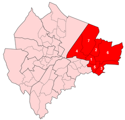
 Map showing Victoria wards within Belfast |
|
| Area | 20.2 km2 (7.8 sq mi) |
| Population | 36,607 (2008 Estimate) |
| • Density | 1,812/km2 (4,690/sq mi) |
| District | |
| County | |
| Country | Northern Ireland |
| Sovereign state | United Kingdom |
| EU Parliament | Northern Ireland |
| UK Parliament |
|
| NI Assembly |
|
Victoria was a special area in Belfast, Northern Ireland. From 1985 to 2014, it was one of the nine "district electoral areas" (DEAs) in the city. Think of a DEA as a large neighbourhood or district that helps choose local leaders. After 2014, most of Victoria became part of a new area called Ormiston.
This district was located in the eastern part of Belfast. It was important because it elected seven people to the Belfast City Council. These people are like local representatives who help make decisions for the community. Victoria included several smaller areas called wards, such as Ballyhackamore, Belmont, Cherryvalley, Island, Knock, Stormont, and Sydenham. Victoria also joined with parts of the nearby Pottinger district and Castlereagh Borough Council to form the Belfast East area for the Northern Ireland Assembly and the UK Parliament.
Victoria had natural borders like the Victoria Channel to the west and Belfast Lough to the north. It also shared borders with other councils, like North Down Borough Council to the northeast and Castlereagh Borough Council to the south and east. To the southwest, it was bordered by the Newtownards Road.
Contents
History of Victoria District
The Victoria district was created in 1985 for local elections. It took over from an older area known as Area B. All seven of Victoria's wards used to be part of Area B. However, one ward from Area B, called Bloomfield, moved to the new Pottinger electoral area. Victoria itself was officially closed down in 2015. This made way for new electoral areas that were used for the 2014 local elections.
Most of Victoria was replaced by the new Ormiston District Electoral Area. Five of Victoria's wards joined Ormiston. The Sydenham ward and the areas that were part of the old Island ward became part of the new Titanic District Electoral Area.
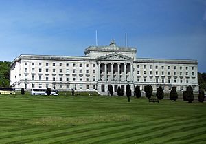
This district was home to many important transport links in Belfast. These included George Best Belfast City Airport and the eastern part of Belfast Harbour. The area also had two railway stations, Bridge End and Sydenham. Major roads like the A2 and A20 also passed through. A very important building in Victoria is Parliament Buildings, where the Northern Ireland Assembly meets to make laws.
Victoria used to be a big centre for heavy industry and manufacturing. Companies here built large ships and aircraft. However, this type of industry has become much smaller since the mid-1900s. Even so, companies like Short Brothers (who make aircraft parts) and Harland and Wolff (famous shipbuilders) still have important operations in the area today.
Old Railway Line
The Belfast and County Down Railway once had a main railway line running through Knock railway station. This line connected Belfast directly to Downpatrick railway station and also to Newcastle, County Down. There was also a branch line from Comber railway station that went to Newtownards and Donaghadee. This main railway line opened in 1850 but was closed in 1950 by the Ulster Transport Authority.
Titanic Quarter: A New Beginning
The Titanic Quarter is a huge project to bring new life to an old part of Belfast. It's focused on Queen's Island and the place where the famous Harland and Wolff shipyard used to be. This project has led to new hotels, apartment buildings, and business offices being built. Many important organisations have moved there, including the Public Record Office of Northern Ireland.
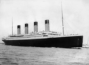
The Titanic Quarter has also become a hub for learning and research. Places like Catalyst Inc have opened, and Belfast Metropolitan College moved one of its main campuses there. Queen's University Belfast also has its Institute of Electronics, Communications and Information Technology (ECIT) in the Science Park within the Quarter. The area is named after the RMS Titanic ship, which was built in the old shipyard. Many projects now use the Titanic's connection to Belfast to attract tourists. These include the giant Samson and Goliath cranes that helped build the ship, and the Paint Hall, a large building used for film and TV production.
Other Cool Places to Visit

The Victoria district electoral area has many other interesting places:
- Ashfield Boys' High School
- Campbell College
- The Comber Greenway, a 7-mile (11 km) path where you can walk or cycle. It follows the route of an old railway line.
- HMS Caroline, a historic warship you can visit.
- Holywood Exchange, a big shopping area.
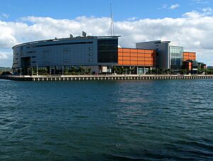
- Odyssey Arena, a large place for concerts and events.
- Our Lady and St. Patrick's College, Knock
- The Oval Stadium, the home ground for Glentoran F.C. (a football club).
- Stormont Estate, a large park with important government buildings.
- Dundonald House
- Stormont Castle
- Stormont House
- Strandtown Primary School
- Strathearn School
- Wilgar Park, the home ground of Dundela F.C. (another football club).
Wards of Victoria

The Victoria district was made up of seven wards. Each ward is a smaller area within the district. Here's a look at them:
| Map | Ward | Population (2011 Census) |
Catholic | Protestant | Other | No Religion | Area | Density | NI Assembly | UK Parliament | Ref |
|---|---|---|---|---|---|---|---|---|---|---|---|
| 1 | Ballyhackamore | 5,939 | 17.2% | 68.2% | 1.9% | 12.7% | 1.15 km2 | 5,164 /km2 | Belfast East | Belfast East | |
| 2 | Belmont | 6,165 | 8.6% | 80.6% | 1% | 9.8% | 1.79 km2 | 3,444 /km2 | Belfast East | Belfast East | |
| 3 | Cherryvalley | 5,920 | 14.5% | 75.3% | 0.8% | 9.4% | 1.99 km2 | 2,975 /km2 | Belfast East | Belfast East | |
| 4 | Island | 5,014 | 13.9% | 69.8% | 4.6% | 11.8% | 3.81 km2 | 1,316 /km2 | Belfast East | Belfast East | |
| 5 | Knock | 4,827 | 9.1% | 79.7% | 1.2% | 10% | 1.12 km2 | 4,310 /km2 | Belfast East | Belfast East | |
| 6 | Stormont | 5,548 | 12.9% | 75.6% | 1.3% | 10.2% | 7.04 km2 | 788 /km2 | Belfast East | Belfast East | |
| 7 | Sydenham | 4,874 | 9.9% | 76% | 1.8% | 12.3% | 6.24 km2 | 781 /km2 | Belfast East | Belfast East | |
| Victoria | 38,287 | 12.4% | 75% | 1.7% | 10.8% | 23.14 km2 | 1,655 /km2 | ||||
Councillors Who Served Victoria
Councillors are local politicians elected to represent the people in their area. They work on issues like local services, planning, and community projects. The table below shows some of the councillors who represented the Victoria District Electoral Area over the years, along with their political parties.
| Election | Councillor (Party) |
Councillor (Party) |
Councillor (Party) |
Councillor (Party) |
Councillor (Party) |
Councillor (Party) |
Councillor (Party) |
|||||||
|---|---|---|---|---|---|---|---|---|---|---|---|---|---|---|
| 2011 | Mervyn Jones (Alliance) |
Laura McNamee (Alliance) |
Andrew Webb (Alliance) |
Jim Rodgers (UUP) |
Tom Haire (DUP) |
John Hussey (DUP) |
Robin Newton (DUP) |
|||||||
| 2005 | Naomi Long (Alliance) |
Ian Adamson (UUP) |
David Rodway (DUP) |
Wallace Browne (DUP) |
||||||||||
| 2001 | David Alderdice (Alliance) |
Alan Crowe (UUP)/ (Independent Unionist) |
||||||||||||
| 1997 | Danny Dow (Alliance) |
|||||||||||||
| 1993 | John Alderdice (Alliance) |
Tommy Patton (UUP) |
||||||||||||
| 1989 | Alan Montgomery (UUP) |
|||||||||||||
| 1985 | Oliver Napier (Alliance) |
George Thompson (Alliance) |
William Corry (UUP) |
Dorothy Dunlop (UUP) |
||||||||||
 | Shirley Ann Jackson |
 | Garett Morgan |
 | J. Ernest Wilkins Jr. |
 | Elijah McCoy |


