
Victorian Downtown Los Angeles facts for kids
_to_Third_Street_(l).jpg)
Imagine Los Angeles over 100 years ago, during the late 1800s! Back then, the downtown area was growing fast. Around 1880, the main business hub was near the Los Angeles Plaza. Over the next 20 years, it stretched south and west along Main Street, Spring Street, and Broadway, reaching towards Third Street.
Most of the buildings from the 1800s are gone today. Only a few remain near the Plaza or south of Second Street. Many were torn down to make space for the Civic Center district, which now has City Hall, many courthouses, and other government buildings. This article explores that old downtown area, from the Plaza to Third Street, and from Los Angeles Street to Broadway, during the years 1880 until the 1920s-1950s when many buildings were removed.
Back then, people simply called this area the "business center." By 1910, the business district had grown even further south, and this older part was known as the "North End."
Where Was Old Downtown Los Angeles?

By the mid-1890s, the corner of First and Spring streets was the busiest spot in downtown. The famous Bradbury Building, which opened in 1893 at Third and Broadway, marked the southwest edge of this busy area. It's still standing today!
By 1910, the area north of Fourth Street was called the "North End" of the business district. People were already starting to worry that this part was getting old, as new businesses were moving south to what is now called the Historic Core, between Third and Ninth streets.
How the Streets Changed
This map shows the streets in 1910. The blue lines on the map highlight three big changes that happened to the roads between the 1920s and 1950s:
- Spring Street was moved north of First Street to run straight, next to Main Street.
- Temple Street was extended eastward from Main Street.
- The US-101 Freeway was built, along with its service roads (Arcadia and Aliso streets). These new roads weren't exactly where the old Arcadia and Aliso streets used to be.
A Look at the Area

This amazing panoramic photo from around 1900-1902 shows how busy downtown Los Angeles was. You can see many buildings that were important back then. Sadly, most of these buildings were later torn down. Today, much of this area is home to the modern Civic Center, including the large City Hall.
Important Buildings
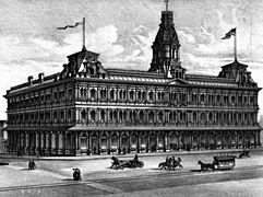
The main streets of old downtown Los Angeles – Broadway, Spring Street, Main Street, and Los Angeles Street – were lined with many important buildings. These included shops, offices, hotels, and theaters that made up the heart of the city's business and social life.
Getting Around: Transportation in Old LA
People in old Los Angeles had several ways to travel around the city and to nearby towns.
-
This picture from around 1890 shows the Baker Block and a horse-drawn streetcar.
-
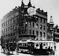
The Temperance Temple building at Temple and Fort (now Broadway) streets, with a cable car in 1890.
-
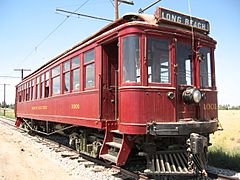
A "Red Car" from the Pacific Electric railway.
-
An electric streetcar from the Los Angeles Railway in 1891.
-
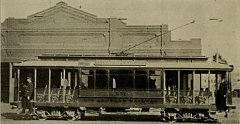
An electric streetcar on Main Street around 1896.
-
Another electric streetcar from the Los Angeles Railway, around 1900-1910.


_(14735748166).jpg)

.jpg)
Horse-Drawn Streetcars (1874–1897)
The very first streetcars in Los Angeles were pulled by horses! They started running in 1874. These horse-drawn cars were used until 1897, when they were replaced by electric ones.
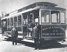
Cable Cars (1885-1902)
Cable cars started operating in Los Angeles in 1885, especially up and down Bunker Hill. These cars were pulled by a moving cable under the street. Three different companies ran cable car lines until 1902. After that, these lines were also changed to use electric streetcars. There were about 25 miles of cable car routes, connecting downtown Los Angeles to areas like Lincoln Heights, Echo Park, and Pico-Union.
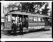
Electric Streetcar Systems (1887–1963)
Electric streetcars became very popular, starting in 1887. Over time, many smaller companies joined together to form two big networks:
- In 1901, a man named Henry E. Huntington bought many electric streetcar companies. He combined them into the Los Angeles Railway, famous for its "yellow cars" that mostly served areas within the city of Los Angeles.
- In 1902, Huntington and a banker named Isaias W. Hellman created the Pacific Electric Railway. This company bought other railways and provided service to towns all around Los Angeles, in what is now Greater Los Angeles. Their "Red Cars" were famous for connecting many communities. The Pacific Electric Building, which had a train station underneath, opened in 1905 at 6th and Main Street.
Funiculars
Have you ever heard of a funicular? It's like a small railway that goes up and down a steep hill. In old Los Angeles, Angel's Flight and Court Flight were funiculars that carried people from Broadway up Bunker Hill.
Train Stations
Los Angeles had several important train stations where people could catch trains to other cities.
-
The Los Angeles & San Pedro Railroad Depot, around 1880.
-
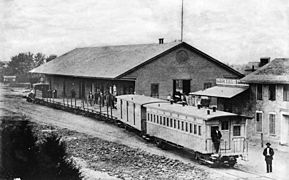
The Los Angeles and Independence Railroad Depot in 1875.
-
The Southern Pacific Railroad's Arcade Depot, around 1895-1900.
-
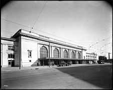
The Southern Pacific Railroad's Central Station, around 1918.
-
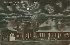
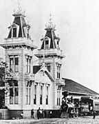
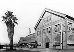
The La Grande Station of the Santa Fe Railway, around 1915.
.jpg)
.jpg)
.jpg)
.jpg)

- The Los Angeles & San Pedro Railroad Depot was at the corner of Alameda and Commercial streets.
- The Los Angeles and Independence Railroad Depot was at San Pedro and 5th street.
- The Arcade Depot of the Southern Pacific Railroad was on Alameda Street. It opened in 1888 and closed in 1914.
- The La Grande Station of the Atchison, Topeka and Santa Fe Railway was at Santa Fe and 2nd streets. It opened in 1893 and closed in 1939.
- The Central Station of the Southern Pacific Railroad was at Central and 5th streets. It opened in 1914. The Union Pacific Railroad also started using this station in 1924. It closed in 1939.
- Finally, Union Station opened in 1939. It replaced both the Central and La Grande stations, becoming the main train hub for Los Angeles.
