
Virudhunagar facts for kids
Quick facts for kids
Virudhunagar
|
|
|---|---|
|
Town
|
|
.JPG) |
|

Virudhunagar
Location in Tamil Nadu
|
|
| Country | |
| State | Tamil Nadu |
| District | Virudhunagar |
| Revenue Division | Aruppukkottai |
| Taluk | Virudhunagar |
| Government | |
| • Type | Selection Grade Municipality |
| • Body | Virudhunagar municipality |
| Area | |
| • Total | 6.39 km2 (2.47 sq mi) |
| Elevation | 120 m (390 ft) |
| Population
(2011)
|
|
| • Total | 72,296 |
| • Density | 11,314/km2 (29,303/sq mi) |
| Languages | |
| • Official | Tamil |
| Time zone | UTC+5:30 (IST) |
| PIN |
626 001
|
| Telephone code | 04562 |
| Vehicle registration | TN-67 |
Virudhunagar is a city in the Tamil Nadu state of India. It is the main administrative center for the Virudhunagar district. The city is located about 506 kilometers (314 miles) southwest of Chennai, the state capital. It is also about 53 kilometers (33 miles) south of Madurai.
Virudhunagar became an important place for trade during the time of British rule. The city is mostly flat, with an average height of 102 meters (335 feet) above sea level. It has a humid climate and gets about 780 mm (31 inches) of rain each year. Over time, different groups ruled Virudhunagar, including the Later Pandyas, Vijayanagar Empire, Madurai Nayaks, and the British. The city was once known as Virudhupatti.
A local government called a municipality manages Virudhunagar, which covers an area of 6.39 square kilometers (2.47 sq mi). In 2011, the city had a population of 72,296 people. Most of the jobs in Virudhunagar are in the service sector, which means people work in areas like trade, transport, and other services. Roads are the main way to travel here, but the city also has train connections. The closest airport is Madurai Airport, about 45 kilometers (28 miles) away. Virudhunagar has many schools and colleges, including a government medical college.
Contents
The Story Behind Virudhunagar's Name
According to an old story, a brave warrior came to the town. He had won many flags, called virudhu in Tamil, from his victories in other kingdoms. He challenged the people of the town. A local resident accepted the challenge and defeated the warrior, taking his flags. Because of this event, the town was first called Virudhukkalvetti.
How Virudhunagar Got Its Name Today
The town's name was changed to Virudhupatti in 1875. Later, on April 6, 1923, the town council decided to rename it Virudhunagar. This name has stayed ever since.
Virudhunagar Through History
In the 16th century, Virudhunagar was part of the Madurai region. This region included most of southern Tamil Nadu. The Nayaks, a ruling family, made the region independent from the Vijayanagar Empire in 1559.
After the Nayak rule ended in 1736, the area saw many changes. Different rulers like Chanda Sahib and the Arcot Nawab controlled it. In 1801, the British East India Company took direct control. It became part of the Madras Presidency.
Virudhunagar was a very important trading center during the British rule. Goods from Virudhunagar were sent overseas through ports like Thoothukudi.
Famous People from Virudhunagar
The town is the birthplace of K. Kamaraj. He was a freedom fighter who helped India gain independence. He also served as the Chief Minister of Tamil Nadu from 1954 to 1963. Kamaraj received the Bharat Ratna, which is India's highest award for civilians.
Geography and Climate of Virudhunagar
Virudhunagar municipality covers an area of 6.39 square kilometers (2.47 sq mi). It is located 506 kilometers (314 miles) southwest of Chennai. The city is also 53 kilometers (33 miles) south of Madurai. The city is mostly flat, with an average height of 102 meters (335 feet).
Land and Soil
The town is located east of the Kowsika River. The land is largely flat, with no big mountains or hills. The soil is a mix of black and red types. This soil is good for growing crops like cotton, chilies, spices, and millet. Farmers also grow paddy (rice) and sugarcane where they can use motor pumps for irrigation.
Weather Patterns
Virudhunagar has a hot, semi-arid climate. This means it's generally hot and dry. Like the rest of Tamil Nadu, the city experiences hot weather from April to June. December and January are cooler. The average daily temperature ranges from about 30°C (86°F) to 38.5°C (101.3°F).
The town gets an average of 829.6 mm (32.66 inches) of rain each year. This is less than the state average. The South-west monsoon (June to August) brings little rain. Most of the rain comes during the North-east monsoon in October, November, and December.
Natural Resources
Lime, also known as Limekankar, is the main mineral found in Virudhunagar. This mineral is used by cement factories in the area.
| Climate data for Virudhunagar | |||||||||||||
|---|---|---|---|---|---|---|---|---|---|---|---|---|---|
| Month | Jan | Feb | Mar | Apr | May | Jun | Jul | Aug | Sep | Oct | Nov | Dec | Year |
| Mean daily maximum °C (°F) | 31.726 (89.11) |
34.321 (93.78) |
37.871 (100.17) |
36.967 (98.54) |
38.094 (100.57) |
37.6 (99.7) |
36.79 (98.22) |
36.726 (98.11) |
36.15 (97.07) |
35.742 (96.34) |
30.95 (87.71) |
30.097 (86.17) |
35.25 (95.46) |
| Mean daily minimum °C (°F) | 19.661 (67.39) |
20.625 (69.13) |
22.113 (71.80) |
24.433 (75.98) |
24.581 (76.25) |
24.717 (76.49) |
25.21 (77.38) |
24.79 (76.62) |
24.383 (75.89) |
23.323 (73.98) |
21.29 (70.32) |
22.6 (72.7) |
23.14 (73.66) |
| Average rainfall mm (inches) | 18.5 (0.73) |
23.5 (0.93) |
37.6 (1.48) |
76.8 (3.02) |
60.2 (2.37) |
18.3 (0.72) |
31.1 (1.22) |
51.6 (2.03) |
80.8 (3.18) |
191 (7.5) |
175.5 (6.91) |
64.7 (2.55) |
829.6 (32.64) |
| Source: Virudhunagar district website | |||||||||||||
People and Economy of Virudhunagar
| Religions in Virudhunagar | ||||
|---|---|---|---|---|
| Religion | Per cent(%) | |||
| Hindu | 85.02% | |||
| Muslim | 7.73% | |||
| Christian | 7.09% | |||
| Sikh | 0.02% | |||
| Other | 0.14% | |||
| Historical population | ||
|---|---|---|
| Year | Pop. | ±% |
| 1951 | 46,456 | — |
| 1961 | 54,871 | +18.1% |
| 1971 | 61,904 | +12.8% |
| 1981 | 68,040 | +9.9% |
| 1991 | 70,971 | +4.3% |
| 2001 | 72,081 | +1.6% |
| 2011 | 72,296 | +0.3% |
Sources:
|
||
In 2011, Virudhunagar had a population of 72,296 people. There were 1,014 females for every 1,000 males, which is higher than the national average. About 6,454 children were under the age of six. The average literacy rate (people who can read and write) was 84.28%, which is higher than the national average.
How People Live and Work
Most people in Virudhunagar work in the service sector. This means they provide services rather than making goods. Only a small part of the workforce is involved in farming or manufacturing. The town has some oil mills and factories that make matches.
Virudhunagar is known for its trade in millet, cotton, and edible oils. Many major nationalized banks and private banks have branches and ATMs in the town.
Getting Around Virudhunagar
The Virudhunagar municipality takes care of over 78 kilometers (49 miles) of roads. Major roads include National Highway 44. These roads connect Virudhunagar to nearby towns like Sivakasi and Madurai. A bypass road helps reduce traffic inside the town.
Bus Services
The town has a bus service that helps people travel within the city and to nearby areas. There are also private mini-bus services. The main bus stand is in the center of town. The Tamil Nadu State Transport Corporation runs daily buses to many cities from Virudhunagar. Long-distance buses connect the town to important cities like Chennai.
Train Connections
The Virudhunagar railway station is an important stop on the railway line from Madurai to Kanyakumari. The Southern Railway operates daily express trains to places like Chennai, Tuticorin, and Kanyakumari. There are also passenger trains connecting the town to Madurai and other nearby places.
Air Travel
The closest airport to Virudhunagar is Madurai Airport. It is about 45 kilometers (28 miles) northeast of the town.
Education and Services in Virudhunagar

Virudhunagar has 14 secondary schools. There are also two arts and science colleges, one for men and one for women. The town has a polytechnic college and three university study centers. A Deemed University called Kalasalingam University is located nearby in Krishnankovil.
Electricity and Water
The Tamil Nadu Electricity Board (TNEB) manages the electricity supply in Virudhunagar. Water is supplied to the town by the Virudhunagar municipality from three different sources. In 2000–01, about 3.86 million liters of water were supplied daily to homes.
Waste Management and Healthcare
About 35 metric tonnes of solid waste are collected from Virudhunagar every day. The municipality collects waste from homes and then sorts and disposes of it. The town does not have an underground drainage system. Waste is managed through septic tanks and open drains.
There are 35 hospitals in the town, along with a traditional siddha dispensary and two municipal maternity homes. These facilities provide healthcare for the citizens. The municipality also maintains street lights and operates three markets for the town and surrounding areas.
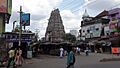
Fun Places to Visit in Virudhunagar
- The Arulmigu Sri Meenakshi Chokkanathaswamy Temple is a very old Shiva temple, believed to be 1000 years old.
- The Sri Veyilugandhamman Tirukkovil is an Amman temple. The old name of Virudhunagar, Veyilugandalpattanam, might have come from this goddess. An annual festival is held here in April/May.
- The Parashakti Mariamman Temple is a Hindu temple in the center of town. A big annual festival is celebrated here in April.
- The house of K. Kamaraj has been turned into a memorial. It is a popular place for visitors in Virudhunagar.
- The Kullursandai reservoir is a great spot to see many migratory birds.
Images for kids
-
Skyline of Virudhunagar
See also
 In Spanish: Virudhunagar para niños
