Kanyakumari facts for kids
Quick facts for kids
Kanyakumari
Cape Comorin
|
|
|---|---|
| Kanniyakumari | |
Vivekananda Rock Memorial, Kanyakumari
|
|
| Nickname(s):
Kumari, Thiruvenisangam
|
|
| Country | India |
| State | Tamil Nadu |
| District | Kanyakumari |
| Named for | Devi Kanya Kumari |
| Government | |
| • Type | Town panchayat |
| • Body | Kanyakumari Town Panchayat |
| Area | |
| • Total | 25.89 km2 (10.00 sq mi) |
| Elevation | 60 m (200 ft) |
| Population
(2011)
|
|
| • Total | 29,761 |
| • Density | 665/km2 (1,720/sq mi) |
| Languages | |
| • Official | Tamil |
| Time zone | UTC+5:30 (IST) |
| PIN |
629 702
|
| Telephone code | 91-4652 & 91-4651 |
| Vehicle registration | TN 74 & TN 75 |
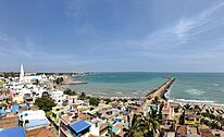
Kanyakumari (UK: /kənˈjʌkʊmæriː/) is a city in Tamil Nadu, India. Its name means "The Virgin Princess". This refers to Devi Kanya Kumari, a goddess. The city is also officially known as Kanniyakumari. It was once called Cape Comorin.
Kanyakumari is at the very southern tip of the Indian subcontinent. It is the southernmost city in mainland India. Because of this, people often call it "The Land's End". The city is about 90 kilometres (56 mi) south of Thiruvananthapuram. It is also about 20 kilometres (12 mi) south of Nagercoil. Nagercoil is the main town of the Kanyakumari district.
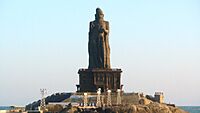
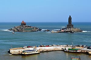
This city is a popular place for tourists and pilgrims in India. Many people visit to see its amazing sunrises and sunsets. Other famous spots include the 41-metre (133 ft) Thiruvalluvar Statue. There is also the Vivekananda Rock Memorial just off the coast. Kanyakumari is at the tip of India. It is surrounded by the Laccadive Sea on its west, south, and east sides. Its coastline stretches for 71.5 kilometres (44.4 mi) along these three sides.
On the city's shore is a temple. It is for the goddess Kanya Kumari. The city is named after her. Kanyakumari has been a town since ancient times. It was mentioned in old writings and by famous travelers like Ptolemy and Marco Polo.
Contents
History of Kanyakumari
How Kanyakumari Got Its Name
The city gets its name from the goddess Kanya Kumari. She is believed to be the sister of Krishna. People believe this goddess helps remove worries from the mind. Women often pray at her temple for a good marriage. In 1656, the Dutch East India Company took over Portuguese Ceylon. The name "Kanyakumari" changed over time to "Comorin". It was then called "Cape Comorin" during British rule in India. In 2016, the Indian government officially changed the name back to "Kanniyakumari".
Ancient Legends
There are many old stories about Kanyakumari. One Hindu legend tells of Kanya Devi. She was a form of the goddess Parvati. She was supposed to marry Shiva. But Shiva did not arrive on their wedding day. The rice and grains for the wedding feast were left uncooked. Over time, these grains turned into stones. Some people believe the small, rice-like stones on the shore today are those very grains. Kanya Devi is now seen as a virgin goddess. She blesses all who visit the town. Her temple in Kanyakumari is a very holy place. It is important in the Shaktism tradition of Hinduism.
Another legend is about Hanuman. He was carrying a mountain with a special healing herb. This was during the Ramayana War. He dropped a piece of earth near Kanyakumari. This fallen earth formed an area called Marunthuvazh Malai. This means "hills where medicine lives". This story explains why there are so many unique medicinal plants in the area. Marunthuvazh Malai is near Kottaram. It is about 7 km (4 mi) from Kanyakumari town. The wise man Agasthya was an expert in herbs. He is thought to have lived here long ago. There is a special place for meditation, an ashram, on the hillside. Visitors can trek up to see it and enjoy views of the sea.
People of Kanyakumari
| Religion in Kanyakumari town (2011) | ||||
|---|---|---|---|---|
| Religion | Percent(%) | |||
| Christian | 61.16% | |||
| Hindu | 32.97% | |||
| Muslim | 5.47% | |||
| Other | 0.39% | |||
In 2011, a study showed the people living in Kanyakumari town. About 61.16% were Christian. 32.97% were Hindu. And 5.47% were Muslim. The total population was 19,739 people. There were 9,884 males and 9,855 females. This means there were 997 females for every 1,000 males.
About 2,403 people were under six years old. For children under six, there were 1,024 females for every 1,000 males. The town's average literacy rate was 88.62%. This is higher than the national average of 59.5%. There were 4,236 homes in the town. Most people worked in various jobs. A small number worked in farming or household industries.
Geography and Climate
Kanyakumari is located at 8°05′N 77°34′E / 8.08°N 77.57°E. It is about 30 meters above sea level. The tip of Kanyakumari is surrounded by the Laccadive Sea on three sides. It is where the Western Ghats and Eastern Ghats mountain ranges meet. The closest big city is Thiruvananthapuram, Kerala. It is about 85 km (53 mi) away. The closest town is Nagercoil. It is about 22 km (14 mi) away.
Kanyakumari is the southernmost point of the main Indian Subcontinent. People often use the phrase "Kashmir se Kanyakumari". This describes the entire length of India. However, the absolute southernmost point of Republic of India is Indira Point. This is on Great Nicobar Island.
Weather in Kanyakumari
| Climate data for Kanyakumari (1981–2010, extremes 1961–2012) | |||||||||||||
|---|---|---|---|---|---|---|---|---|---|---|---|---|---|
| Month | Jan | Feb | Mar | Apr | May | Jun | Jul | Aug | Sep | Oct | Nov | Dec | Year |
| Record high °C (°F) | 34.4 (93.9) |
34.8 (94.6) |
36.0 (96.8) |
36.8 (98.2) |
38.2 (100.8) |
36.2 (97.2) |
35.3 (95.5) |
35.9 (96.6) |
35.5 (95.9) |
35.2 (95.4) |
35.6 (96.1) |
33.7 (92.7) |
38.2 (100.8) |
| Mean daily maximum °C (°F) | 31.1 (88.0) |
31.8 (89.2) |
32.4 (90.3) |
32.8 (91.0) |
32.4 (90.3) |
30.6 (87.1) |
30.4 (86.7) |
30.5 (86.9) |
30.6 (87.1) |
30.5 (86.9) |
30.3 (86.5) |
30.5 (86.9) |
31.2 (88.1) |
| Daily mean °C (°F) | 27.3 (81.1) |
27.9 (82.2) |
28.9 (84.0) |
29.6 (85.3) |
29.4 (84.9) |
27.6 (81.7) |
27.3 (81.1) |
27.3 (81.1) |
27.5 (81.5) |
27.4 (81.3) |
27.3 (81.1) |
27.2 (81.0) |
27.9 (82.2) |
| Mean daily minimum °C (°F) | 23.6 (74.5) |
24.0 (75.2) |
25.3 (77.5) |
26.3 (79.3) |
26.3 (79.3) |
24.7 (76.5) |
24.3 (75.7) |
24.2 (75.6) |
24.4 (75.9) |
24.4 (75.9) |
24.2 (75.6) |
23.9 (75.0) |
24.6 (76.3) |
| Record low °C (°F) | 19.8 (67.6) |
18.8 (65.8) |
21.4 (70.5) |
20.9 (69.6) |
21.3 (70.3) |
19.3 (66.7) |
19.0 (66.2) |
21.3 (70.3) |
21.0 (69.8) |
20.2 (68.4) |
20.1 (68.2) |
19.0 (66.2) |
18.8 (65.8) |
| Average rainfall mm (inches) | 14.1 (0.56) |
7.0 (0.28) |
17.9 (0.70) |
61.9 (2.44) |
58.7 (2.31) |
87.7 (3.45) |
43.9 (1.73) |
31.8 (1.25) |
44.1 (1.74) |
121.5 (4.78) |
176.7 (6.96) |
50.2 (1.98) |
715.5 (28.17) |
| Average rainy days | 0.9 | 1.0 | 1.4 | 2.8 | 3.1 | 6.3 | 3.8 | 2.5 | 3.5 | 7.3 | 8.7 | 3.0 | 44.2 |
| Average relative humidity (%) (at 17:30 IST) | 66 | 68 | 70 | 74 | 77 | 79 | 79 | 79 | 80 | 80 | 75 | 68 | 75 |
| Source: India Meteorological Department | |||||||||||||
Kanyakumari has a warm climate all year. The average temperature stays around 27-29 degrees Celsius. It gets most of its rain from October to November. The driest months are January and February. Humidity is usually high, around 75%.
Famous Places to Visit
Thiruvalluvar Statue
The Thiruvalluvar Statue is a huge stone statue. It weighs 7,000 tons! It honors the poet and thinker Valluvar. The statue itself is 29 metres (95 feet) tall. It stands on an 11.5-metre (38 ft) rock. This rock represents the 38 chapters of good deeds in the Thirukkural. The statue on the rock shows that wealth and love should be built on strong values. The total height of the statue and its base is 133 ft (40.5 m). This stands for the 133 chapters in the Thirukkural.
The statue looks like a dancing pose of Nataraja. A famous Indian artist, V. Ganapati Sthapati, created it. It was opened on January 1, 2000. The monument survived the 2004 Indian Ocean earthquake and tsunami in 2004 without damage. It is built to withstand strong earthquakes. Sometimes, if the sea is rough or for maintenance, visitors cannot go to the statue.
Vivekananda Rock Memorial
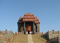
The Vivekananda Rock Memorial is another popular place to visit. It is on one of two rocks in the Laccadive Sea. This rock is about 500 metres (1,600 ft) east of the mainland. It was built in 1970 to honor Swami Vivekananda. He is believed to have found inner peace on this rock. Local stories say that Goddess Kumari also meditated here.
There is a special meditation hall inside the memorial. Visitors can use it to meditate quietly. The building's design mixes different styles of temple architecture from all over India. It has a statue of Vivekananda. The memorial has two main parts: the Vivekananda Mandapam and the Shripada Mandapam.
Bhagavathy Amman Temple
The Bhagavathy Amman Temple is very old, about 3,000 years old. It is dedicated to Goddess Kumari Amman. It is right on the shore of the Laccadive Sea. Kumari Amman is a form of the goddess Devi. This temple is believed to be the first Durga temple built by Lord Parasurama. It is also one of the 108 holy places called Shakthi Peethas. The temple is mentioned in ancient Indian stories like the Ramayana and Mahabharata.
Gandhi Memorial Mandapam
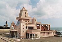
The Gandhi Memorial Mandapam is a special monument. It was built where the ashes of Mahatma Gandhi were placed. People came to see them before they were scattered in the sea. The memorial looks like Hindu temples from central India. It was designed so that on Gandhi's birthday, October 2, the first rays of the sun shine directly on the spot where his ashes were kept.
Kanyakumari Pier
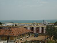
The Kanyakumari Pier, also called Sunset View Point, is a famous spot. It is unique because it is where three oceans meet. These are the Bay of Bengal, the Laccadive Sea (part of the Indian Ocean), and the Arabian Sea. It's a great place to watch the sunset.
Kamarajar Mani Mantapa Monument
The Kamarajar Mani Mantapa Monument honors K. Kamarajar. He was a freedom fighter and a former Chief Minister of Tamil Nadu. He was also the President of the Indian National Congress. Many people called him "Black Gandhi". Like the Gandhi Memorial, this monument is where Kamarajar's ashes were kept for public viewing before they were scattered in the sea.
Tsunami Memorial Park
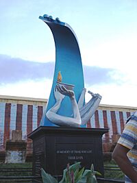
Near the southern shore of Kanyakumari, there is a monument. It remembers those who died in the 2004 Indian Ocean earthquake and tsunami. This huge underwater earthquake caused a giant wave. It took about 230,000 lives in many countries. These included India, Sri Lanka, and Indonesia.
Getting Around Kanyakumari
Ferry Services
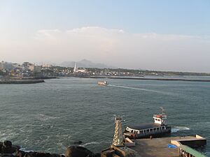
The state-owned Poompuhar Shipping Corporation runs ferry services. These ferries take tourists between the town and the Vivekananda Rock Memorial. They also go to the Thiruvalluvar Statue. Both of these are on rocky islands off the coast. The ferry service started in 1984. More ferries have been added over the years to help more visitors.
Train Travel
The Kanyakumari railway station is nearby. So is the Nagercoil railway station. These stations offer direct train connections. You can travel by train to almost all major cities in India from here.
Air Travel
The closest airport is Thiruvananthapuram International Airport. It is about 90 km (56 mi) from Kanyakumari town. It is about 70 km (43 mi) from Nagercoil. Kanyakumari is also 744 km (462 mi) from Chennai.
Kanyakumari also has special landing spots for helicopters. These are for important visitors. They are located at the Tri Sea Hotel on Beach Road.
Local Areas
- Peyode
See also
 In Spanish: Kanyakumari para niños
 | May Edward Chinn |
 | Rebecca Cole |
 | Alexa Canady |
 | Dorothy Lavinia Brown |


