Wabigoon River facts for kids
Quick facts for kids Wabigoon River |
|
|---|---|

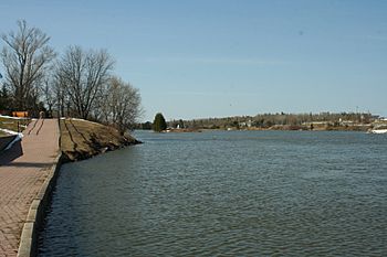
The Wabigoon River as it exits Wabigoon Lake
|
|
|
Location of the mouth of the Wabigoon River in Ontario
|
|
| Country | Canada |
| Province | Ontario |
| Region | Northwestern Ontario |
| District | Kenora |
| Physical characteristics | |
| Main source | Raleigh Lake 453 m (1,486 ft) 49°28′08″N 91°56′12″W / 49.46889°N 91.93667°W |
| River mouth | English River 314 m (1,030 ft) 50°15′46″N 93°58′46″W / 50.26278°N 93.97944°W |
| Length | 235 km (146 mi) |
| Basin features | |
| River system | Hudson Bay drainage basin |
| Tributaries |
|
The Wabigoon River is a river in northwestern Ontario, Canada. It flows through the Kenora District. The river starts at Raleigh Lake and flows past the town of Dryden, Ontario. It then joins the English River. The name "Wabigoon" comes from the Ojibwe people. It means "marigold" or "white feather."
Contents
Journey of the Wabigoon River
The Wabigoon River begins its journey at Crocker Bay in Raleigh Lake. It flows northwest, going over Raleigh Falls. The river then passes under Ontario Highway 17 and the Canadian Pacific Railway main train line near the small town of Raleigh.
River's Path and Connections
The river continues its northwest path. It meets the Little Wabigoon River, which flows into it from the right. Then, it turns southwest, again passing under the Canadian Pacific train line and Highway 17 near Taché. The Mennin River joins from the left. The Wabigoon River then flows over Walker Falls. Melgund Creek also joins from the right, all near Borups Corners.
Through Lakes and Towns
The river then enters Dinorwic Lake. From there, it flows into Wabigoon Lake. Here, the Crooked River joins it from the left. The Wabigoon River leaves Wabigoon Lake at Dryden. It then flows northwest through the Wainwright Township dam. This dam has a power station that makes electricity.
Final Stretch to English River
Further along, the Eagle River joins from the left. The Wabigoon River passes under Ontario Highway 105 at Upper Falls. It then goes under Ontario Highway 609 and the Canadian National Railway main train line. It also flows over Quibell Dam, all near the town of Quibell. The river then heads northwest to Clay Lake. The Canyon River joins it at Canyon Stretch. Finally, the Wabigoon River flows through Segise Lake and reaches its end at Ball Lake. Here, it joins the English River. The English River eventually flows into the Winnipeg River and then the Nelson River, which empties into Hudson Bay.
Protecting the Wabigoon River
In the past, the Wabigoon River faced a big challenge. In 1962, a company in Dryden started making chemicals. This process released a harmful substance called mercury into the river. The mercury spread through the Wabigoon-English River system.
Impact on Nature and People
This mercury got into the food chain. Fish in the river absorbed it. For the First Nations people living on reserves at Grassy Narrows and Whitedog, fish were a very important part of their diet. Eating these fish caused serious health problems, like issues with the brain and birth defects. This situation also led to the closure of local fishing businesses.
Steps Towards Healing
In 1985, an agreement was made to help the affected communities. The Canadian government, the provincial government, and the companies involved agreed to provide support. Today, the amount of mercury in the river water is much lower. While some older, larger fish still have higher levels, the overall mercury levels have dropped a lot in recent years. This shows how efforts can help rivers heal.
Rivers Joining the Wabigoon
Many smaller rivers and creeks flow into the Wabigoon River. These are called tributaries. They add water to the main river as it flows.
- Wolf Creek (left side)
- Canyon River (left side)
- Clay Lake
- Beaton Creek (right side)
- Redbluff Creek (right side)
- Blackbluff Creek (right side)
- Hutchinson Creek (left side)
- Buller Creek (right side)
- Colenso Creek (right side)
- Mutrie Creek (right side)
- Eagle River (left side)
- Beaver Creek (left side)
- Shoshowae Creek (left side)
- Rugby Creek (right side)
- Gullwing Creek (right side)
- Swanson's Creek (right side)
- Wabigoon Lake
- McLeod's Creek (left side)
- Threefork Creek (left side)
- Pitchinese Creek (left side)
- Blackwater Creek (right side)
- Nugget Creek (right side)
- Dinorwic Lake
- Tobacco Creek (left side)
- Crooked River (left side)
- McKenzie Creek (right side)
- Battie Creek (right side)
- Melgund Creek (right side)
- Mennin River (left side)
- Little Wabigoon River (right side)
 | William L. Dawson |
 | W. E. B. Du Bois |
 | Harry Belafonte |


