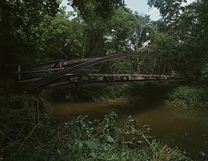
Wakatomika Creek facts for kids

Wakatomika Creek is a stream in central Ohio, United States. It flows for about 42.6 miles (68.6 km) and is a smaller stream that flows into the Muskingum River. The Muskingum River then joins the Ohio and Mississippi River, making Wakatomika Creek part of a very large river system. It drains an area of about 234 square miles (606 km²).
Contents
Where Wakatomika Creek Flows
Wakatomika Creek begins in western Coshocton County. From there, it flows west into Knox County. Then, it turns south, moving through parts of northeastern Licking and southwestern Coshocton Counties. Finally, it flows east through northwestern Muskingum County, passing by the town of Frazeysburg. The creek eventually joins the Muskingum River from the west at the village of Dresden.
Scientists measure how much water flows in the creek. Near Frazeysburg, the average amount of water flowing each year is about 158 cubic feet per second. This is like filling 158 boxes, each one foot on every side, with water every second! The most water recorded in a single day was 9,200 cubic feet per second on June 28, 1998, after a lot of rain. The least amount was only 2.6 cubic feet per second on October 3, 1963, during a very dry time.
Creek's Start and End Points
- Where it ends: The creek meets the Muskingum River at Dresden. 40°07′33″N 82°00′05″W / 40.1259025°N 82.0015248°W
- Where it starts: It begins in Coshocton County, east of Newcastle. 40°19′39″N 82°08′46″W / 40.3275677°N 82.1459802°W
Smaller Streams Joining the Creek
Many smaller streams, called tributaries, flow into Wakatomika Creek. They add more water to the main creek.
- Winding Fork flows from southern Perry Township and northwestern Pike Township in Coshocton County. It joins Wakatomika Creek near the State Route 79 bridge.
- Brushy Fork comes from Perry Township in Licking County. It empties into Wakatomika Creek in the very northwestern part of Muskingum County.
- Black Run joins Wakatomika Creek just southwest of Frazeysburg.
- Little Wakatomika Creek flows into Wakatomika Creek near where state routes 60 and 16 meet.
History of Wakatomika Creek
The name "Wakatomika Creek" comes from a Shawnee village called Wakatomika. This village was located right where the creek meets the Muskingum River, which is now near the town of Dresden, Ohio. In 1774, during a conflict known as Lord Dunmore's War, the village was destroyed.
After the American Revolution, the valley along Wakatomika Creek was one of the first places in what is now Muskingum County where white Americans settled. Today, a large building belonging to the Longaberger Basket Company is located in the Wakatomika Valley, between Frazeysburg and Dresden.
Over time, Wakatomika Creek has also been known by several other names, such as Tomica Creek, Tomaky Run, and Wakatomaka Creek.
 | Emma Amos |
 | Edward Mitchell Bannister |
 | Larry D. Alexander |
 | Ernie Barnes |

