Wales, South Yorkshire facts for kids
Quick facts for kids Wales |
|
|---|---|
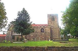
 St. John the Baptist church |
|
| Area | 10.29 km2 (3.97 sq mi) |
| Population | 1,260 (2011 census) Civil parish: 7,069 |
| • Density | 122/km2 (320/sq mi) |
| OS grid reference | SK480829 |
| Civil parish |
|
| Metropolitan borough |
|
| Metropolitan county | |
| Region | |
| Country | England |
| Sovereign state | United Kingdom |
| Post town | SHEFFIELD |
| Postcode district | S26 |
| Dialling code | 01909 |
| Police | South Yorkshire |
| Fire | South Yorkshire |
| Ambulance | Yorkshire |
| EU Parliament | Yorkshire and the Humber |
| UK Parliament |
|
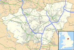
Wales is a small village and a local area (called a civil parish) in South Yorkshire, England. It's part of the Metropolitan Borough of Rotherham. Long ago, it was part of the West Riding of Yorkshire. The village is located near Derbyshire and sits right next to the M1 motorway. The entire civil parish of Wales includes the village itself and the nearby area of Kiveton Park. In 2011, about 7,069 people lived in the civil parish.
Contents
What's in a Name? The History of "Wales"
The village of Wales shares its name with the country of Wales. It's thought that both names come from the same old word. This word is *Walhaz, which was used by Germanic people across Europe. They used it to describe the people who had adopted Roman ways in the old Roman Empire.
This suggests that the name of the village might mean that a group of "British" people continued to live in this area. They kept their own language and culture even after the Anglo-Saxons arrived. Another idea is that the name Wales comes from the word Waelas. This word means "field of battle."
A Look Back: The History of Wales Village
The village of Wales was first written about in the year 1002. It was called Walesho back then. A Saxon nobleman named thegn Wulfric Spot owned it. Later, in the Doomsday Book, the village was recorded as Walise.
Sir William Hewet, who became the Lord Mayor of London in 1559, was born in Wales. His family, later known as the Dukes of Leeds, became very powerful in the area.
In the past, many people in Wales worked in coal mines. The mines at Waleswood and Kiveton Park provided many jobs. Some workers even moved here from the country of Wales. Kiveton Park Colliery closed in September 1994.
Waleswood: A Nearby Hamlet
Waleswood is a small group of houses (called a hamlet) located to the north-west of Wales. In the past, Waleswood was known for Waleswood Hall. Later, it became famous for the Waleswood Colliery, which was a coal mine. This mine even had its own railway station. Today, much of the old mine site is home to the Gulliver's Valley theme park.
Wales Bar: Another Hamlet
Wales Bar is another small hamlet located to the west of Wales. This area has many houses built in the 20th century for miners. Many people who lived here used to work in the coal mines nearby, like Waleswood and Brookhouse.
Where is Wales? Geography of the Village
The village of Wales is located at about 53 degrees, 20 minutes, 30 seconds North, and 1 degree, 16 minutes, 45 seconds West. It sits at a height of about 300 feet (which is about 100 meters) above sea level. The village is on the A618 and B6059 roads.
The M1 motorway cuts through the parish. The southern edge of the area is partly marked by the Chesterfield Canal. The Norwood Tunnel of this canal runs underground to the south. To the west of the village, you can find Rother Valley Country Park.
Learning and Working: Education and Employment in Wales
Children in Wales go to Wales Primary School for their early education. Older students attend Wales High School.
The Wales Common industrial estate is a big place for jobs in the area. Many companies are located there. For example, Greencore Prepared Foods makes food products. Also, LuK, which is part of a large manufacturing group, makes clutch and car parts.
 | James Van Der Zee |
 | Alma Thomas |
 | Ellis Wilson |
 | Margaret Taylor-Burroughs |


