Wellesley Islands facts for kids
Quick facts for kids Wellesley IslandsQueensland |
|||||||||||||||
|---|---|---|---|---|---|---|---|---|---|---|---|---|---|---|---|

Location map
|
|||||||||||||||
| Population | 1,136 (2016 census) | ||||||||||||||
| • Density | 1.1279/km2 (2.921/sq mi) | ||||||||||||||
| Postcode(s) | 4892 | ||||||||||||||
| Area | 1,007.2 km2 (388.9 sq mi) | ||||||||||||||
| Time zone | AEST (UTC+10:00) | ||||||||||||||
| LGA(s) | Shire of Mornington | ||||||||||||||
| State electorate(s) | Traeger | ||||||||||||||
| Federal Division(s) | Kennedy | ||||||||||||||
|
|||||||||||||||
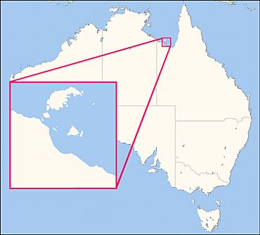
The Wellesley Islands are a group of islands located off the coast of northern Queensland, Australia. They are found in the large Gulf of Carpentaria. These islands are part of a special area called the Shire of Mornington. In 2016, about 1,136 people lived on the Wellesley Islands.
Contents
Exploring the Geography of Wellesley Islands
The biggest island in this group is Mornington Island. The town of Gununa is on Mornington Island. This is where all the people living in the Wellesley Islands locality make their homes.
Important Bird Areas
Two smaller islands in the Wellesley group are very special for birds. They form the Manowar and Rocky Islands Important Bird Area. This means these islands are a safe and important place for seabirds to breed and raise their young.
Nearby Islands and Regions
Other island groups like the South Wellesley Islands and the Forsyth Islands are also in this area. They are all part of the Mornington Shire. Together, these islands are part of a larger natural region called the Gulf Plains bioregion of Australia.
A Look at Wellesley Islands History
The Lardil language is an Aboriginal language spoken by the local people. It is used on Mornington Island and the northern Wellesley Islands. This language is an important part of the culture in the Mornington Shire.
How the Islands Got Their Name
The islands were first mapped by Matthew Flinders on December 6, 1802. He likely named them later, between 1803 and 1810. At that time, Flinders was held captive on Mauritius. He probably named the islands to honor Richard Wellesley, 1st Marquess Wellesley.
Richard Wellesley was a very important British leader. He served as the Governor of Madras and later as the Governor-General of Bengal in India. He tried to help Flinders get released from captivity. Flinders also named the largest island, Mornington Island, after Wellesley, who was also known as the second Earl of Mornington.
Education on the Islands
The Mornington Island State School first opened its doors on January 28, 1975. This school has been an important part of the community for many years.
The Indigenous Origin Story of the Islands
Local Indigenous people have a special story about how the islands were formed. This story has been passed down through generations.
They believe that long ago, the islands were not islands at all. They were part of a piece of land connected to mainland Australia. People could walk freely across this land without needing boats.
The Story of Garnguur
According to their belief, a seagull woman named Garnguur changed the land. She used her raft to drag it back and forth across the narrow part of the land. This caused the sea to flow in, turning their homes into the islands we see today.
In the beginning, as far back as we remember, our home islands were not islands at all as they are today. They were part of a peninsula that jutted out from the mainland and we roamed freely throughout the land without having to get in a boat like we do today. Then Garnguur, the seagull woman, took her raft and dragged it back and forth across the neck of the peninsula letting the sea pour in and making our homes into islands.
Education Opportunities on Wellesley Islands
Mornington Island State School is a public school for both boys and girls. It teaches students from early childhood up to Year 10. The school is located on Lardil Street.
School Facilities and Programs
In 2018, the school had 263 students. There were 25 teachers and 14 other staff members helping students. The school also has a special education program to support students with different learning needs.
Options for Higher Grades
Currently, there are no schools on the island that offer education up to Year 12. There are also no nearby schools for these higher grades. Students who want to continue their education past Year 10 have a couple of options. They can study through Distance education, which means learning from home. Another option is to attend a boarding school away from the island.
 | Selma Burke |
 | Pauline Powell Burns |
 | Frederick J. Brown |
 | Robert Blackburn |


