West Peak (Jefferson County, Washington) facts for kids
Quick facts for kids West Peak |
|
|---|---|

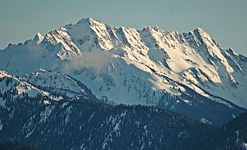
West Peak in winter
|
|
| Highest point | |
| Elevation | 7,365 ft (2,245 m) |
| Prominence | 1,965 ft (599 m) |
| Geography | |
| Parent range | Olympic Mountains |
| Topo map | USGS Mount Steel |
| Climbing | |
| First ascent | 1930 by E. B. Hamilton |
| Easiest route | Scrambling class 3 via Flypaper Pass |
West Peak is a tall mountain, about 7,365 feet (2,245 meters) high. It is part of the Olympic Mountains in Jefferson County, Washington state. This peak stands in the middle of Olympic National Park. It is the highest point on the Anderson Massif, which is a large group of mountains.
West Peak is special because it's the "watery top" of the Olympic Mountains. This means that rain and snow that fall here flow in three different directions. The water goes to the Pacific Ocean through the Quinault River. It also flows to the Strait of Juan de Fuca by way of the Elwha River. Finally, some water goes to Hood Canal through the Dosewallips River.
There are two glaciers on West Peak. The Eel Glacier is on the east side of the mountain. Another unnamed glacier is on the south side. The closest higher mountain is Mount Mystery, which is about 7.73 miles (12.44 km) away to the northeast.
The first people to climb West Peak reached the top in 1930. This climb was made by E. B. Hamilton. Some people believe the mountain is named after Mr. West. He was part of an exploration trip in the Olympic Mountains in 1890. The West Branch of the Quinault River was also named after him that same year.
Mountain Weather
West Peak is in a "marine west coast" climate zone. This means it's near the ocean and gets a lot of rain and snow. Most of the weather systems start over the Pacific Ocean. They then move northeast towards the Olympic Mountains.

When these weather systems hit the tall Olympic peaks, the air is forced to rise. As the air goes higher, it cools down and drops its moisture. This causes a lot of rain or snow to fall on the mountains. This process is called Orographic lift. Because of this, the Olympic Mountains get a lot of precipitation, especially snow in the winter.
During the winter, the weather is often cloudy. However, in the summer, high-pressure systems over the Pacific Ocean become stronger. This often leads to clear skies with little or no clouds. The best time to climb West Peak, when the weather is usually good, is from June through September.
How the Mountains Formed
The Olympic Mountains are made of special kinds of rock. These rocks were once part of the ocean floor and pieces of land pushed together. They are mostly Eocene rocks, which means they formed a very long time ago. These rocks include sandstone, turbidite (rock formed from underwater landslides), and basalt (a type of volcanic rock from the ocean floor).
The shape of these mountains was created during the Pleistocene era. This was a time when large sheets of ice, called glaciers, moved across the land. These glaciers carved out valleys and peaks as they advanced and then melted away many times. This process of erosion by glaciers helped sculpt the mountains into what we see today.
 | Emma Amos |
 | Edward Mitchell Bannister |
 | Larry D. Alexander |
 | Ernie Barnes |


