
West Roxbury facts for kids
Quick facts for kids
West Roxbury
|
||
|---|---|---|

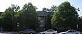
Centre Street in West Roxbury
|
||
|
||

West Roxbury is a neighborhood located in the southwest corner of the city of Boston.
|
||
| Country | United States | |
| State | Massachusetts | |
| County | Suffolk | |
| City | Boston | |
| Settled | 1630 | |
| Founded | 1851 | |
| Area | ||
| • Total | 4.61 sq mi (11.9 km2) | |
| • Land | 4.56 sq mi (11.8 km2) | |
| • Water | 0.05 sq mi (0.1 km2) | |
| Population
(2010)
|
||
| • Total | 30,446 | |
| • Density | 6,676.8/sq mi (2,577.9/km2) | |
| Time zone | UTC-5 (Eastern) | |
| Zip Code |
02132
|
|
| Area code(s) | 617 / 857 | |

West Roxbury is a neighborhood in Boston, Massachusetts, United States. It shares borders with Roslindale and Jamaica Plain to the northeast. To the north, you'll find Chestnut Hill and Brookline. The city of Newton is to the northwest. To the southwest are Dedham and Needham. Finally, Hyde Park is to the southeast. It's important to know that West Roxbury is often confused with Roxbury. However, these two neighborhoods are actually separated by Roslindale and Jamaica Plain.
Before 1630, the Wampanoag Indian Tribe lived in this area. West Roxbury was founded in 1630, at the same time as Boston. It was originally part of the town of Roxbury and was mostly used for farming. In 1851, West Roxbury separated from Roxbury. It then became part of Boston in 1874. The area used to include the neighborhoods of Jamaica Plain and Roslindale.
Centre Street is the main shopping area in West Roxbury. West Roxbury Main Streets is a local group that helps improve and promote businesses there. The neighborhood has mostly single-family homes, but also some two-family houses. Many people who work for the city of Boston live here.
West Roxbury is home to important public services. This includes District E-5 of the Boston Police Department. Boston Emergency Medical Services has an ambulance and paramedics stationed here. There are also two Boston fire stations. The MBTA Commuter Rail network has three stations in West Roxbury. These are Bellevue, Highland, and West Roxbury. Several MBTA bus lines also run through the neighborhood. A large Veterans Affairs hospital is located near the Dedham line. West Roxbury also has many places of worship. This includes Catholic churches, Protestant churches, and a Jewish synagogue.
The neighborhood was once home to Brook Farm. This was an experimental community based on transcendentalism. Famous people like Margaret Fuller and Nathaniel Hawthorne visited Brook Farm. Hawthorne's 1852 novel The Blithedale Romance is based on his time there. West Roxbury grew as the Boston and Providence Railroad was built. Electric streetcars also helped the area develop further.
Contents
West Roxbury's Population Changes
This section looks at how the number of people living in West Roxbury has changed over time. Until the 2000 census, West Roxbury's population seemed to be getting a little smaller. However, it increased in the 2010 census. This might be because the City of Boston and Massachusetts used new ways to count people.
Here's a quick look at the population numbers:
- 2010 Census: 30,446 people
- 2000 Census: 28,663 people
- 1990 Census: 29,706 people
- 1980 Census: 31,333 people
Between 2000 and 2010, the population grew by 6.2%. From 1990 to 2000, it went down by 3.51%. And from 1980 to 1990, it decreased by 5.19%.
West Roxbury has historically been a neighborhood with many Irish Catholic families. In the 1900s, many Irish Americans moved here from other parts of Boston. By the early 2000s, more new residents moved in. This made the neighborhood more diverse, with people from many different backgrounds.
The Irish Social Club of Boston moved its main building to West Roxbury in 1978. It was founded in Dorchester in 1945. In the mid-1970s, the club had 15,000 members. The club closed in 2011 because of money problems and fewer members. At that time, it had about 300 members, mostly older people. With help from the city and state, the club got a new license and reopened. By 2013, it had about 800 members again.
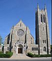
Theodore Parker Church
The Theodore Parker Church is located at Centre and Corey Streets. It has seven beautiful stained glass windows. These windows were made by Tiffany Studios between 1894 and 1927. The first church building was designed in 1890 by Alexander Wadsworth Longfellow Jr.. This building is now used as a parish hall. Henry Seaver designed the current church in 1900. Theodore Parker (1810–1860) was a minister for this church from 1837 to 1846. He was known for his progressive religious ideas. He also supported ending slavery and giving women the right to vote.
Westerly Burying Ground: A Look at History
Westerly Burying Ground, also called Westerly Burial Ground, is located at Centre and LaGrange Streets. It was started in 1683. This allowed people from Jamaica Plain and the western part of Roxbury to be buried closer to home. Before this, the closest burial place was far away in what is now Eliot Burying Ground. Traveling that distance was difficult for West Roxbury residents. So, in 1683, town leaders decided to create a local burial ground.
This burial ground played a role in West Roxbury separating from Roxbury in 1851. There was a disagreement between the rural and more urban parts of the town. West Roxbury officially became part of the City of Boston on January 5, 1874. Westerly Burying Ground was used for burials well into the 1800s. The oldest graves belong to some of the town's first and most important families. Eight veterans from the American Revolution and fifteen veterans from the American Civil War are also buried here. You can find more details about the Civil War veterans in the article “Westerly" and the Civil War.
The site has many examples of funerary art from three centuries. About one-third of the existing gravestones are from the 1700s. Almost half are from the 1800s, and about twenty are from the 1900s. Westerly Burying Ground has many individual mound tombs. These are small mounds built over a single grave. At other burial grounds, mound tombs are usually larger and hold many bodies. The oldest gravestone is from 1691. It honors James and Merriam Draper, who were part of an important West Roxbury family. The headstones were skillfully carved locally. They provide a historical record of West Roxbury residents over three centuries.
Boston United Hand in Hand Cemetery
Boston United Hand in Hand Cemetery is on Centre Street. It sits right on the border with Dedham. This cemetery dates back to 1875. The first section was full by 1896. However, it was made larger many times after that. There are graves as recent as 1980 in the West Roxbury part. The Dedham part of the cemetery is still in use today. Congregation Mishka Tefila, a group from Chestnut Hill, currently owns the cemetery.
Education in West Roxbury
West Roxbury has several schools for students of all ages.
Public Schools
Boston Public Schools runs the public schools in the area. These include Ludwig van Beethoven Elementary School, William Ohrenberger School, Joyce Kilmer K-8 School, and Patrick Lyndon K-8 School. The West Roxbury Education Complex used to house three high schools: Media Communications Technology High School, Parkway Academy of Technology and Health, and the Urban Science Academy. However, these schools closed in 2019 because of problems with the building's structure.
Private Schools
There are also private schools in West Roxbury. The Roxbury Latin School is a private school for boys. The Roman Catholic Archdiocese of Boston operates two Catholic schools: Holy Name Parish School and St. Theresa of Avila School. Catholic Memorial School is another private school for boys. It includes both middle and high school grades and is located on Baker Street.
Public Libraries

The Boston Public Library operates the West Roxbury Branch Library. In 1876, the city library took over the West Roxbury Free Library. They started a delivery service in West Roxbury. The West Roxbury location became a full library branch in 1896. A new library building was built on the current site in 1921 and 1922. In 1973, a fire destroyed the church next door. The land where the church stood was given to the library. This allowed for an addition to be built. The new addition opened to the public on September 24, 1989.
Fun Events in West Roxbury
West Roxbury hosts several community events throughout the year.
Corrib Classic 5K Road Race
The Corrib Classic 5K Road Race happens every year at Billings Field on LaGrange Street. It takes place on the first Sunday in June. This event started in 1994 with 250 runners. It has grown to be the largest community event, attracting about 2000 runners. Many volunteers, families, and friends also come to support. Centre and Lagrange Streets are briefly closed during the race. This race is a benefit event hosted by the Bligh family, who own the nearby Corrib Pub and Restaurant. Over the years, it has raised more than half a million dollars for various local causes.
Parkway Little League Parade
The Parkway Little League Parade is a small event that kicks off the little league baseball and softball season. It's for kids in West Roxbury and Roslindale. Young baseball and softball players put on their team uniforms. They march from Fallon Field in Roslindale to the Guy Cammarata Complex in West Roxbury.
Shamrock Shootout
The Shamrock Shootout is an annual street hockey tournament. It takes place in West Roxbury. This event started in 2008 for neighborhood kids who had a day off school for Evacuation Day. The tournament is free to enter, but you need to register.
Famous People from West Roxbury
Many notable individuals have connections to West Roxbury:
- Nathan Blecharczyk, co-founder of Airbnb
- Ellery Clark, U.S. Olympic champion from Athens 1896
- Rich Cronin, singer, songwriter, and lead singer for LFO
- Patrick DeCoste, rock guitarist
- Edward Downes, music expert and radio quizmaster
- Sears Gallagher, a well-known American artist
- Anthony Michael Hall, actor
- Alfred Clifton Hughes, former Roman Catholic Archbishop of New Orleans
- Thomas G. Kelley, Medal of Honor recipient from the Vietnam War
- Dan Kiley, a modern landscape architect
- Willis Lent, a rear admiral in the United States Navy
- William Martin, novelist
- Joe Nash, former NFL player
- Chris Nilan, former NHL player and coach
- Richard Olney, former United States Attorney General and Secretary of State
- Ron Perry, Holy Cross basketball player
- Jack Rathbone, NHL player for the Vancouver Canucks
- Taylor Schilling, actress
- Robert Gould Shaw, an officer in the Union Army during the American Civil War
- Francis A. Sullivan, professor and theologian
- Kevin White, who was mayor of Boston for 20 years
Places to Visit in West Roxbury
West Roxbury has many interesting places to see:
- The Roxbury Latin School
- Bellevue Standpipe, located on Bellevue Hill in Stony Brook Reservation
- Holy Name Parish School
- Saint Teresa of Ávila Church (Roman Catholic)
- Westerly Burial Ground
- Catholic Memorial School
- Theodore Parker Church
- Boston Public Library West Roxbury Branch
- Millennium Park
- Brook Farm—a 1840s experiment in communal living
- City of Boston Archives
- Veterans Administration Hospital
- Annunciation Melkite Catholic Cathedral Located on the VFW Parkway
Gallery
-
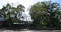
Westerly Burying Ground, general view
-
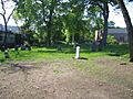
Westerly Burying Ground, close-up 1
-
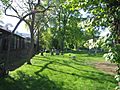
Westerly Burying Ground, close-up 2
-
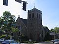
Theodore Parker Church (Unitarian)
-
West Roxbury Free Library, 1921-2 wing
-

Centre Street, West Roxbury's main artery
-
Saint Teresa of Ávila Church (Roman Catholic)


