
Wom Brook facts for kids
| Wom Brook | |
|---|---|
 Wom Brook at the Rookery footbridge, close to the eastern end of the walk. |
|
| Location | |
| Village: | Wombourne |
| County: | Staffordshire |
| Country: | England, U.K. |
| Wom Brook Walk | |
| Length: | 1.5 miles (2.6 km) |
| Status: | Local nature reserve |
| Established: | 2004 |
| Awards: | Green Flag Award |
| Administration | |
| Administrative authority: | South Staffordshire District Council |
| Groups: | Friends of Wom Brook |
The Wom Brook is a small stream in South Staffordshire, England. It flows through the village of Wombourne. This stream has been very important to the area's history. It is a key part of the River Smestow and the larger River Severn river system.
Contents
What's in a Name?
The name "Wom Brook" probably comes from the village name, Wombourne. The word "Wombourne" might mean "Crooked Stream." This makes sense because the stream does wind and turn.
Long ago, streams were called "burna" in Old English. Later, the word "brōca" was used, which is where "brook" comes from. So, "Wom Brook" is a newer name for this stream.
The Journey of Wom Brook

The Wom Brook starts from pools at the Wodehouse. These pools are fed by other streams like the Penn Brook and Lyden Brook. These smaller streams bring water from the Colton Hills near Wolverhampton.
The brook flows south-west, going under roads and reaching the edge of Wombourne village. This is where the Wom Brook Walk begins!
The stream then reaches the Pool Dam. This was once a forge mill, where metal was shaped using water power. The water tumbles down here. It flows past the village centre and then opens up into Ham Meadow. This is a lovely area with grass and trees.
Next, the Wom Brook goes under the South Staffordshire Railway Walk. It drops again and enters the Giggetty area. Here, it winds through trees, flowing below the nearby houses.
After Giggetty, the brook briefly goes underground through a culvert. This is a tunnel under a road and the Staffordshire and Worcestershire Canal. Walkers take a short detour here. The brook then comes out at Longford.
Soon after, the Merryhill Brook joins the Wom Brook. This happens near Tyre Hill, which used to be a quarry. The Wom Brook then flows through the Poolhouse estate. Finally, it goes under the Bridgnorth road and through industrial areas. It then joins the River Smestow near the village of Smestow.
Wom Brook's Industrial Past

The Wom Brook was very important for industries in Wombourne for many centuries. Even though the water flow changed a lot, it provided power. Around 1086, the Domesday Book recorded two mills in Wombourne. These mills used water wheels to grind grain or do other work.
From the Middle Ages, the rivers in this area were known for making iron. By the 1600s, there was a huge demand for iron. Mills on the Wom Brook used water power to run machines that hammered, rolled, and cut iron. Rich iron-masters built dams and canals to make sure there was enough water.
The Industrial Revolution brought new ways to make iron using coal. The Staffordshire and Worcestershire Canal, built in 1770-72, made it easy to move iron and materials. This helped the iron industry along the Wom Brook grow even more.

Maps from 1775 show three important mills on the Wom Brook. These were at the Wodehouse, Pool Dam, and Heath Forge. The Wodehouse had a large watermill since at least 1570. It was used for grinding corn and fulling (cleaning cloth). The building you see today dates back to 1840.
Around 1800, the Heath Mill became even bigger. The Merryhill Brook was redirected to create a huge mill pond. This pond had a large waterfall that powered several mills. The Foley family, who owned the mills, became very rich. They built a big house above the Wom Brook. The main mill later switched to grinding corn and was used for over 100 more years.
By the mid-1800s, many people in Wombourne made nails and did other iron work. The Wom Brook provided power or cooling water for these businesses. The Heath Mill also used the brook to grow watercress and raise fish.
After the mid-1800s, water power became less important. Steam engines, powered by coal, were more reliable and cheaper. The Wom Brook lost its industrial role. The mills closed, and the area changed.
Today, Wombourne is a place where people live and work in lighter industries. Houses and businesses spread along the brook. But the risk of flooding kept a green area along the stream. This allowed wildlife to return. The Wom Brook is now important for fun and nature. The Wom Brook Walk was created in 2004. In 2008, it became a local nature reserve.
Exploring the Wom Brook Walk

The Wom Brook Walk is about one and a half miles long. It follows the Wom Brook on one or both sides. You can walk all of it or just one of its four sections: Pool House estate, Giggetty, Wombourne Village West, and Wombourne Village East. Since becoming a local nature reserve in 2008, it has won a Green Flag Award.
The walk starts on the western side of Wombourne, near the Pool House estate. It begins in a small forest and then opens up into grassy areas with old trees like oak and willow.
The path goes through a housing area but stays in a small valley. Near Longford, you can cross a small bridge. This bridge looks like the "Poohsticks" bridge from the Winnie-the-Pooh stories! After Longford, you take a short detour over the canal to reach the Giggetty section. This part has bushes and wooded banks, with the stream winding over a gravel bed.
The walk then meets the South Staffordshire Railway Walk. You need to go up and down paths to get back to the stream. This leads to the Wombourne Village West section, which includes Ham Meadow. This is an open, hilly area near the village centre. The winding stream has cut a deep valley through the meadow, with trees along its sides.
At Lower End, you cross the road into the Wombourne Village East section. This part has open grassy areas with views of the village, and also thicker woodland. Here, you can take a small detour to see the Pool Dam. This was the site of an old forge watermill. The walk ends near Rushford Bridge, which crosses an old road.
The entire walk is within Wombourne village, where you can find parking. Signs now show the way at all crossings. Information boards explain interesting local and historical facts. The whole walk is good for wheelchair users, but the slopes at the railway walk can be steep.
Wildlife Along the Brook
The Wom Brook is home to many amazing animals! In 2005, a survey found a group of water voles living here. These animals are becoming rare, so it's exciting to see them.
You might also spot colourful kingfishers and dippers. Other common animals include grey herons, long-eared bats, green woodpeckers, bees, and butterflies. In 2010, people were very excited when Wombourne's first little egret was seen hunting and resting by the brook!
Streams Joining the Wom Brook

Several smaller streams flow into the Wom Brook. Here are the main ones:
- The Merryhill Brook. This stream starts near Wolverhampton. It flows west and sometimes goes underground. It can flood because of the clay soil. It eventually joins the Wom Brook near Longford.
- The Lyden Brook. This is one of several brooks that drain the area south of Wolverhampton. All of them flow into the Wodehouse mill pool.
- The Penn Brook. This is basically the start of the Wom Brook. The Wom Brook just continues the Penn Brook's journey after it feeds the pools at the Wodehouse. The Penn Brook gets water from streams flowing from the Colton Hills. It starts near Goldthorn Park and flows across Penn Common. This area used to be very wet, but people managed the watercourses to make it usable. The brook passes an old brewery, which it once supplied with water.
For about 300 years, the River Smestow also fed the Wom Brook. Channels were built to take water from the Smestow to power mills and fill pools on the Wom Brook. This helped make sure the mills had enough power. One channel led to Heath Mill, creating a large waterfall. This mill ground corn until the 1930s. The channels and pools are now gone, but you can still trace their path as a walking trail.
Places Along the Wom Brook
The only big village along the Wom Brook is Wombourne.
Images for kids
-
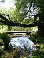
The southern pool at the Wodehouse, where the Wom Brook begins its journey into Wombourne village.
-
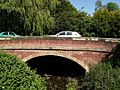
The Wom Brook at Rushford Bridge, entering the village under an old road.
-
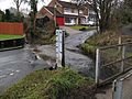
Lower End Bridge, marking the start of the Ham Meadow section.
-
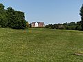
Ham Meadow, a grassy area where the Wom Brook flows.
-
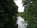
The Wom Brook winding through Ham Meadow.
-
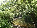
The Wom Brook in the Giggetty Estate, lower down the walk.
-
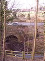
Longford, where the brook briefly goes underground.
-
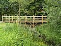
A footbridge on the walk at Longford, inspired by the "Poohsticks" bridge.


