
1812 Ventura earthquake facts for kids
.jpg) |
|
| USGS-ANSS | ComCat |
|---|---|
| Local date | 21 December, 1812 |
| Local time | 11:00 PST (UTC-07:00) |
| Magnitude | 7.0–7.25 Mw 7.1 ML 7.5–7.7 Muk |
| Epicenter | Santa Barbara Channel or Wrightwood 34°12′N 119°54′W / 34.2°N 119.9°W |
| Areas affected | Alta California, New Spain Present day Santa Barbara and Ventura County |
| Max. intensity | X (Extreme) |
| Tsunami | 3.4 m (11.2 ft) |
| Foreshocks | Yes |
| Aftershocks | Yes |
| Casualties | 2 dead |
The 1812 Ventura earthquake (also called the Santa Barbara earthquake) happened on the morning of December 21, 1812. It struck at 11:00 Pacific Standard Time. This powerful earthquake had a magnitude of 7.1 to 7.5. It also caused a huge ocean wave called a tsunami.
The earthquake and tsunami caused a lot of damage. This happened in areas that are now Santa Barbara and Ventura County, California. At that time, this land was part of the Spanish Empire. Sadly, two people died because of the earthquake. This event happened just after another big earthquake on December 8, 1812. Scientists think these two earthquakes might have been connected.
Contents
Why Do Earthquakes Happen in California?
California has many earthquakes because of something called plate boundaries. The Earth's outer layer is made of huge pieces called plates. In California, two of these plates, the Pacific Plate and the North American Plate, are always moving. They slide past each other along a giant crack in the Earth called the San Andreas Fault.
This movement creates many smaller cracks, or faults, all over California. Some faults are hidden under the Santa Barbara Channel. These hidden faults can cause strong earthquakes and tsunamis. The San Andreas Fault has a "Big Bend" in it. This bend causes the land to get squeezed and pushed up. This pushing creates different types of faults, like thrust faults, which force blocks of land upwards.
Where Did the 1812 Earthquake Start?
Scientists are still trying to figure out the exact spot where this earthquake began. They have two main ideas for its origin. Some researchers think it started near Wrightwood, while others believe it began in the Santa Barbara Channel.
Could It Be the San Andreas Fault?
One idea is that the earthquake started on the San Andreas Fault. Scientists looked at tree rings from 1812. They found that trees near the San Andreas Fault showed signs of stress. These trees grew slowly and sometimes even missed rings that year. This suggests something big happened to them.
One idea is that the strong shaking broke the trees' roots. This would stop them from getting enough water and food. The violent shaking might also have knocked off branches.
Some scientists think the December 8 earthquake triggered the December 21 earthquake. They believe the second quake started in the south and moved north along the San Andreas Fault. This would mean a long section of the fault broke.
However, there are reasons to doubt the San Andreas Fault as the only source. If it was the San Andreas, aftershocks should not have been felt much along the coast. But people reported "odd disturbances" in the sea. Also, the 1857 earthquake was stronger and closer to Santa Barbara. Yet, it did not cause as much damage there as the 1812 quake. This makes some scientists think the 1812 quake was not just from the San Andreas.
Could It Be the San Cayetano Fault?
Another idea is that the earthquake started on the San Cayetano Fault. This fault is about 40 kilometers (25 miles) long. It runs from Ventura into the Sespe Mountains.
Scientists looked at the ground along the San Cayetano Fault. They found signs of a big slip that happened between 1660 and 1813. This suggests a powerful earthquake was caused by this fault. They found evidence of two large earthquakes in the last 350 years. These quakes were likely very strong, possibly greater than magnitude 7.0. They probably broke the entire length of the fault.
An earthquake on the San Cayetano Fault would explain the large tsunami. This is because the fault is located closer to the coast.
What Happened During and After the Earthquake?
The first shaking, which was a foreshock, happened around 10:00–10:15 a.m. At Mission La Purisima, people ran out of the buildings. They were still outside when the main earthquake hit about 15 minutes later.
The main earthquake was much more violent. Church bells rang by themselves, and the thick adobe walls of the mission began to crack and fall apart. At Mission La Purisima, a large crack opened in a hillside. Mud and water shot out of it.
.jpg)
Many buildings were damaged at other missions too. This included Mission Santa Ines, Mission Santa Barbara, Santa Barbara Presidio, Mission San Buenaventura (Ventura), and Mission San Fernando. One person died in the Agua Caliente area. Many houses, churches, and chapels completely collapsed. Three adobe buildings were destroyed by the tsunami. At Mission San Buenaventura and Mission Santa Barbara, the damage was very bad. A local man died during an aftershock.
The number of deaths was low for such a big earthquake. This is because the first shaking, the foreshock, gave people a warning. It made many people leave their buildings before the main, stronger earthquake hit.
The damage from this earthquake was similar to the very famous 1906 San Francisco earthquake and the 1857 Fort Tejon earthquake. However, the damage in 1812 was over a smaller area. Many Chumash people who lived on Santa Cruz and Santa Rosa islands were scared. They paddled their canoes to the mainland and moved there. People were afraid of more tsunamis and aftershocks. Because of this, the missions were left empty until April 1813.
The Tsunami
A ship captain named the Thomas Newland was in Refugio Bay. He saw the sea pull back from the shore. Then, a huge wave came back. It lifted his ship and dropped it in Refugio Canyon. After that, the wave pulled the ship back out to sea.
The tsunami waves were measured at 3 to 4 meters (10 to 13 feet) high in Gaviota. Some people who saw it said the wave might have been as high as 15.2 meters (50 feet). The tsunami was also noticed as far away as San Francisco.
Images for kids
-
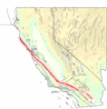
The San Andreas Fault in California.
-
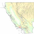
The San Cayetano Fault in Southern California


