
1927 Lompoc earthquake facts for kids
| UTC time | 1927-11-04 13:51:03 |
|---|---|
| ISC event | 909604 |
| USGS-ANSS | ComCat |
| Local date | November 4, 1927 |
| Local time | 5:49 P.M. PST |
| Magnitude | 7.3 Ms |
| Depth | 10.0 km |
| Epicenter | 34°48′47″N 120°46′26″W / 34.813°N 120.774°W |
| Fault | Possibly the Hosgri Fault |
| Type | Unknown (possibly thrust or reverse and/or with some strike-slip component) |
| Areas affected | California |
| Total damage | Limited |
| Max. intensity | X (Extreme) |
| Tsunami | 2 meters (6.6 feet) |
| Landslides | Yes |
| Casualties | None |
The Lompoc earthquake happened on November 4, 1927, at 5:49 a.m. Pacific Standard Time. Its center was off the coast of Lompoc, a town in Santa Barbara County, Southern California. This was one of the biggest earthquakes ever recorded off the California coast. It had a magnitude of 7.3.
This earthquake might have started along the Hosgri Fault, which is a fault line completely underwater. The shaking from the earthquake and a very large tsunami caused some damage to nearby towns. Because the earthquake happened offshore and the area was not very populated back then, no one was killed. This is the only tsunami caused by a California earthquake that was recorded in Hawaii.
Understanding the Geology

The San Simeon-Hosgri Fault is a long and complex fault line. It stretches for about 140 kilometers (87 miles). Most of it is offshore, but about 18 kilometers (11 miles) are on land. This fault runs mostly north-south and dips towards the east. It is actually a system of many connected fault lines that work together.
The Hosgri Fault is similar to the famous San Andreas Fault. It helps to manage the movement between the North American Plate and the Pacific Plate. These are huge pieces of the Earth's crust that are always moving. The fault is a concern for the Diablo Canyon Power Plant, which is a nuclear power plant located only a few kilometers away. After the Fukushima nuclear disaster in 2011, people worried about the power plant's safety. The San Simeon Fault, which is part of this system, caused an earthquake in 2003 that killed two people.
The 1927 Earthquake
The main shaking point, called the epicenter, was about 80 kilometers (50 miles) west of Point Arguello. The earthquake caused large landslides along the coast near the Santa Bárbara District. Because of this, train services had to be stopped.
In towns like Lompoc and others nearby, many chimneys were damaged. In the town of Surf, the shaking was so strong that people were thrown off their feet. A concrete road cracked, and a rail bridge was moved out of place. Sand and water shot out of the ground, which shows that the soil became like liquid during the earthquake. This is called liquefaction.
The shaking was very strong in a small area, reaching level X on the MMI scale. This means it was "Extreme." In a larger area, the shaking was still strong, reaching levels VIII to VI. The earthquake was so powerful that it even stunned and killed many fish near where it happened.
The Tsunami Waves
The earthquake also caused a tsunami, which is a series of ocean waves. These waves reached a height of 2 meters (6.6 feet) at Surf and Pismo Beach. At Port San Luis, the waves were 1.2 meters (3.9 feet) high. Further south, in La Jolla, San Diego, the tsunami was measured at 7 centimeters (2.8 inches).
Eyewitnesses reported that the sea did not pull back before the waves hit. This means the first wave that reached the California coast was a "positive wave," pushing water onto the land. Tide gauges in Hawaii also measured the tsunami. It was 2 centimeters (0.8 inches) high in Honolulu and 10 centimeters (3.9 inches) high in Hilo.
Images for kids
-
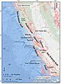
This map shows where the Hosgri Fault is located.
