
A55 road (Great Britain) facts for kids
Quick facts for kids
|
||||
|---|---|---|---|---|
| North Wales Expressway | ||||
 |
||||

Looking eastbound at junction 40
|
||||
| Route information | ||||
| Part of |
||||
| Maintained by Highways England North and Mid Wales Trunk Road Agent |
||||
| Length | 87 mi (140 km) | |||
| Existed | 1922–present | |||
| History | Completed: 2001 | |||
| Major junctions | ||||
| West end | Holyhead | |||
J9 → A487 road J11 → A5 road J19 → A470 road J33B → A494 road J34 → A494 road J38 → A483 road J39 → A41 road/A5115 road J40 → A51 road M53 motorway |
||||
| East end | Chester | |||
| Location | ||||
| Counties: | Isle of Anglesey, Gwynedd, Conwy, Denbighshire, Flintshire, Cheshire | |||
| Primary destinations: |
Holyhead Bangor Conwy Chester |
|||
| Road network | ||||
|
||||

The A55, also known as the North Wales Expressway (Welsh: Gwibffordd Gogledd Cymru), is a very important road in Great Britain. It connects Chester, England, to Holyhead, Wales. For most of its journey, it follows the beautiful north coast of Wales. It's mostly a dual carriageway, which means it has two lanes going in each direction, separated by a barrier. Many parts of the A55 are built like a motorway, allowing traffic to flow smoothly without many stops.
This road is also part of the European route E22. This longer route connects places like Amsterdam, Riga, and Moscow. The A55 used to only go between Bangor and Chester. However, it was extended to Holyhead in 2001. This extension is very important because it links to the Republic of Ireland through the Port of Holyhead. In total, the A55 is about 87 miles (140 km) (140 kilometers) long.
Contents
Exploring the A55 Road in North Wales
The A55 is a key route for people traveling across North Wales. It helps connect towns and cities along the coast. It also makes it easier to reach the ferry port at Holyhead. This port is a main gateway to Ireland.
Connecting Important Places
The A55 passes through several counties in Wales and England. These include Isle of Anglesey, Gwynedd, Conwy, Denbighshire, Flintshire, and Cheshire. Along its route, the A55 has many junctions. These are special places where other roads join or leave the main highway. They help drivers get to different towns and attractions.
Some of the major towns and cities connected by the A55 include:
Special Features of the A55
The A55 is known for some interesting parts of its design. Because it follows the coastline, it has to go through mountains and under rivers. This means there are several tunnels along the road.
Tunnels and Bridges on the Route
- Britannia Bridge: This famous bridge carries the A55 over the Menai Strait. It connects the Isle of Anglesey to the main part of Wales.
- Pen-y-Clip Tunnels: These tunnels help the road pass through a rocky headland near Llanfairfechan.
- Penmaenbach Tunnels: Another set of tunnels that allow the A55 to go through a headland near Penmaenmawr.
- Conwy Tunnel: This is a special tunnel that goes under the River Conwy. It's an immersed tube tunnel, which means it was built in sections on land and then sunk into place underwater.
These tunnels and bridges were big engineering projects. They helped make the A55 a modern and efficient road. They also protect the beautiful natural landscape of North Wales.
How the A55 Helps People
The A55 is more than just a road; it's a vital link for many reasons:
- Tourism: It makes it easy for tourists to visit popular places in North Wales. These include the Snowdonia mountains and coastal towns.
- Trade: Goods and services can be transported quickly along the road. This helps businesses in the region.
- Travel: It provides a fast route for people traveling between England and Wales. It also connects to ferry services for Ireland.
The road is maintained by Highways England and the North and Mid Wales Trunk Road Agent. They work to keep it safe and smooth for all drivers.
Images for kids
-
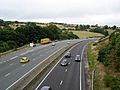
Climbing up Rhuallt Hill eastwards.
-
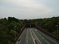
Approaching the tunnel from the west.
-
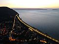
This view at sunset shows how the modern A55 Expressway bypasses the older road through the town centre before resuming the original route around the headland.
-
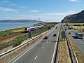
An easterly view of the A55 at Penmaenmawr with the North Wales Coast Railway on the seaward side. The Penmaenbach Tunnels are in the distance
-
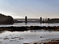
The A55 spans Britannia Bridge, connecting Anglesey to the British mainland.


