
Flintshire facts for kids
Quick facts for kids
Flintshire
Sir y Fflint (Welsh)
|
||
|---|---|---|
|
County
|
||
|
||
|
||

Flintshire shown within Wales
|
||
| Sovereign state | ||
| Constituent country | ||
| Preserved county | Clwyd | |
| Established | 1 April 1996 | |
| Administrative HQ | Mold | |
| Largest town | Connah's Quay | |
| Government | ||
| • Type | Principal council | |
| • Body | Flintshire County Council | |
| Area | ||
| • Total | 169 sq mi (438 km2) | |
| Area rank | 12th | |
| Population
(2015)
|
||
| • Total | 154,100 | |
| • Rank | 6th | |
| • Density | 910/sq mi (352/km2) | |
| • Ethnicity | 97.8% white | |
| Time zone | UTC+0 (Greenwich Mean Time) | |
| • Summer (DST) | UTC+1 (British Summer Time) | |
| Postcode areas |
CH
LL |
|
| Dialling codes | 01352 01745 01244 |
|
| GSS code | W06000005 | |
| ISO 3166-2 | GB-FLN | |
| NUTS 3 code | UKL23 | |
| ONS code | 00NJ | |
| Website | www.flintshire.gov.uk | |


.jpeg)

Flintshire (called Sir y Fflint in Welsh) is a county in the north-east part of Wales. It has a water border with Merseyside along the Dee Estuary to the north. On land, it borders Cheshire to the east, Wrexham County Borough to the south, and Denbighshire to the west. Connah's Quay is the biggest town in Flintshire. The main offices for the Flintshire County Council are in Mold.
The county covers about 438 square kilometers (169 square miles). In 2021, around 155,000 people lived here. After Connah's Quay-Shotton (with 23,000 people), the largest towns are Flint (13,736), Buckley (16,127), and Mold (10,123). The eastern part of Flintshire has many factories and businesses. This area is called Deeside.
The coast near the Dee Estuary also has a lot of industry. Further west, the coast is popular for tourism, especially at Talacre. Away from the coast, the western part of the county has fewer people. It features gentle hills, including part of the beautiful Clwydian Range and Dee Valley area.
Flintshire is named after an older, historic county. This historic county was created in 1284. The current county has different borders than the old one. Flintshire is also part of the Welsh Marches, which are lands along the border between England and Wales.

Contents
A Look Back: Flintshire's History
Flintshire gets its name from an older county. This historic county existed from 1889 until 1974. In 1996, the current Flintshire county was created. It is a bit smaller than the historic one.
Early Times in Flintshire
When the Romans arrived in Britain, the area of Flintshire was home to a Celtic tribe called the Deceangli. There were lead and silver mines here. The Deceangli seemed to accept Roman rule without much fighting.
Later, this region became part of the Kingdom of Mercia by the 700s AD. Offa of Mercia built a large earthwork called Offa's Dyke to mark the border. By 1066, the area was controlled by Edwin of Tegeingl. The coat of arms for Flintshire comes from his family.
How Flintshire Changed Over Time
For many years, Flintshire was part of Cheshire. In the 1200s, parts of the area were taken over by the Kingdom of Gwynedd. In 1284, under King Edward I, Flintshire was officially created as a county. It was managed along with Chester.
In 1536, King Henry VIII made Flintshire part of the Kingdom of England. Flintshire remained a separate local authority until 1974. Then, it joined with other areas to form a larger county called Clwyd.
In 1996, Clwyd was split up. Flintshire was re-established in its current form. However, some parts of the old historic county are now in other areas. For example, English Maelor is now part of Wrexham County Borough.
Where is Flintshire?
Flintshire is a county by the sea. To the north is the Dee Estuary. To the east is Cheshire. To the west is Denbighshire. To the south is Wrexham County Borough. The coast along the Dee Estuary has a lot of industry. The northern coast is popular for tourism.
The Clwydian Range hills cover much of the western part of the county. The highest point is Moel Famau, which is 554 meters (1,820 feet) tall. Important towns include Buckley, Connah's Quay, Flint, Hawarden, Holywell, Mold, Queensferry, and Shotton. The main rivers are the Dee and the River Alyn.
Important Buildings and Bridges
Flintshire has many interesting old buildings and modern structures.
-
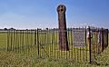
Ancient Cross at Whitford
-
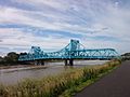
Queensferry Jubilee Bridge


.jpg)

Getting Around: Railways
Flintshire is on the North Wales Coast Line. This line goes from Holyhead to Chester. Trains are run by Avanti West Coast and Transport for Wales. They stop at stations like Flint and Shotton.
At Shotton, you can change trains to the Borderlands Line. This line connects Flintshire stations to the Liverpool area and Wrexham.
What Flintshire Makes: Industry
Many important factories are in Flintshire. Toyota has a plant that makes car engines. Eren Paper also has a factory here. Airbus UK makes wings for large aircraft like the A320, A330, and A350 at Broughton.
Large Airbus BelugaXL planes fly daily from Broughton. They carry the aircraft wings. Flintshire is also home to internet companies. The biggest one is Moneysupermarket.com, located in Ewloe.
The North Wales Coalfield was once important here. The last coal mine at Point of Ayr closed in 1996. Flintshire also has Shotwick Solar Park. It is currently the largest solar farm in the UK. It powers a large paper mill nearby.
Flintshire used to have a big steel industry. Many towns grew around this work. Steelmaking ended in 1980. However, the Shotton Steelworks site still makes coated steel products today. These are mainly used for building.
Fairtrade in Flintshire
On November 19, 2004, Flintshire was given Fairtrade County status. This means the county supports fair trade practices. Fair trade helps farmers and workers in developing countries get a fair price for their products.
Learning in Flintshire: Education
Flintshire County Council is in charge of education in the area. It manages 72 primary schools, 2 special schools, and 11 secondary schools. Six primary schools and one secondary school teach mainly in Welsh.
Four of the secondary schools work together with Coleg Cambria. This group is called the Deeside Consortium.
News and Entertainment: Media
Flintshire has local newspapers. These include the North Wales Daily Post and The Leader.
Two radio stations broadcast in the area. They are Heart North and Mid Wales and Capital North West and Wales. The BBC Cymru Wales has a studio in Wrexham. Local TV news is mainly from BBC Wales and ITV Cymru Wales.
You can also find local news online. Deeside.com covers the Flintshire area from Deeside.
Famous Faces from Flintshire
Many well-known people come from Flintshire.
- Gareth Allen (born 1988) is a former professional snooker player. He was born in Mynydd Isa.
- Saint Asaph was a Christian saint from the 6th century. He was the first Bishop of St Asaph.
- Claire Fox (born 1960) is a writer and politician. She grew up in Buckley.
- William Ewart Gladstone (1809–1898) was Prime Minister of the United Kingdom for 12 years. He retired to Hawarden Castle.
- Jade Jones (born 1993) is a taekwondo athlete. She won Olympic gold medals in 2012 and 2016.
- Michael Owen (born 1979) is a famous footballer. He played for many clubs and for England. He went to school in Hawarden.
- Ian Rush (born 1961) is a well-known footballer. He played for many clubs and for Wales.
- Gary Speed (1969–2011) was a footballer and manager. He played for many clubs and for Wales.
- Frances Williams (around 1760–1801) was the first Welsh woman to live in Australia.
- Sir Jonathan Pryce (born 1947) is a famous actor. He was born in Holywell.
Flintshire's International Friends
Flintshire has a special friendship agreement with one town:
 Menden, Germany
See also
 In Spanish: Flintshire para niños
