Aberdeen, North Carolina facts for kids
Quick facts for kids
Aberdeen
|
||
|---|---|---|

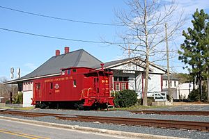
Aberdeen train station
|
||
|
||

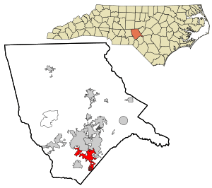
Location in Moore County and the state of North Carolina.
|
||
| Country | United States | |
| State | North Carolina | |
| County | Moore | |
| Incorporated | 1893 | |
| Named for | Aberdeen, MS | |
| Government | ||
| • Type | Commissioner-manager | |
| Area | ||
| • Total | 10.63 sq mi (27.52 km2) | |
| • Land | 10.44 sq mi (27.04 km2) | |
| • Water | 0.19 sq mi (0.48 km2) | |
| Elevation | 381 ft (116 m) | |
| Population
(2020)
|
||
| • Total | 8,516 | |
| • Density | 815.71/sq mi (314.94/km2) | |
| Time zone | UTC-5 (Eastern (EST)) | |
| • Summer (DST) | UTC-4 (EDT) | |
| ZIP code |
28315
|
|
| Area codes | 910, 472 | |
| FIPS code | 37-00160 | |
| GNIS feature ID | 2405118 | |
| Website | www.townofaberdeen.net | |
Aberdeen is a town located in Moore County, North Carolina, in the United States. In 2020, about 8,516 people lived there. It's a place with a rich past and a growing community.
Contents
Exploring Aberdeen's Past
Early Settlers and Beginnings
The first European settlers in the Aberdeen area were Scottish people. They arrived around 1745. They liked the area because it had great hunting and lots of untouched land. By the late 1700s, they had started two communities called Bethesda and Blue's Crossing.
Aberdeen During the American Revolution
During the American Revolution, most people in what is now Aberdeen supported the British. They were called Loyalists. There were a few small fights nearby. One famous event happened at Ray's Mill Creek. A Loyalist guide named Kenneth Black was badly beaten there.
Early Industries and Trade
One of the first big businesses in Bethesda and Blue's Crossing was making "naval stores." These were products like tar and pitch, which came from the many pine trees in the area. They were used to build and maintain ships. These goods were first sent to market by the Cape Fear River to Wilmington. Later, a special plank road helped transport them.
The Civil War and Railroad's Arrival
Over 1,500 people from the Aberdeen area fought in the Civil War. Sadly, almost one-third of these soldiers died. This greatly reduced the number of workers available. After the war, things started to look up. The Raleigh and Augusta Air Line Railroad connected Blue's Crossing to the rest of the country. This made it easier to sell their naval stores and timber far away.
A New Name and Growth
In 1877, a post office opened in the town. Malcolm J. Blue became the first postmaster. A few years later, Allison F. Page bought a lot of forest land. He planned to build a rail line and clear the land for timber. This land was later sold to James Walker Tufts for a very low price. It eventually became the famous golf resort, Pinehurst Resort. In 1888, Blue's Crossing officially changed its name to Aberdeen.
Modern Aberdeen: Tourism and History
In the early 1900s, tobacco farming became popular in Aberdeen. The town's closeness to Pinehurst also led to a big increase in tourism and people moving there to retire. These industries are still very important to Aberdeen's economy today.
Several historic places in Aberdeen are recognized nationally. These include the Aberdeen Historic District, Bethesda Presbyterian Church, John Blue House, and Malcolm Blue Farm.
Geography and Nature
Where is Aberdeen Located?
Aberdeen covers about 10.63 square miles (27.52 square kilometers). Most of this area is land, with a small part being water.
Waterways in Aberdeen
Aberdeen Creek flows right through the middle of Aberdeen. This creek is a "tributary," which means it's a smaller stream that flows into a larger river. Aberdeen Creek flows into Drowning Creek, which is part of the Lumber River system.
Education Opportunities
Schools in Aberdeen
Aberdeen has several schools for students of different ages:
- The Academy of Moore County
- Aberdeen Elementary School
- Southern Middle School
Older students in the area attend Pinecrest High School. For those looking for higher education, Sandhills Community College is also nearby.
Population and People
How Many People Live Here?
| Historical population | |||
|---|---|---|---|
| Census | Pop. | %± | |
| 1890 | 227 | — | |
| 1900 | 559 | 146.3% | |
| 1910 | 794 | 42.0% | |
| 1920 | 858 | 8.1% | |
| 1930 | 1,382 | 61.1% | |
| 1940 | 1,076 | −22.1% | |
| 1950 | 1,603 | 49.0% | |
| 1960 | 1,531 | −4.5% | |
| 1970 | 1,592 | 4.0% | |
| 1980 | 1,945 | 22.2% | |
| 1990 | 2,700 | 38.8% | |
| 2000 | 3,400 | 25.9% | |
| 2010 | 6,350 | 86.8% | |
| 2020 | 8,516 | 34.1% | |
| 2022 (est.) | 9,305 | 46.5% | |
| U.S. Decennial Census | |||
A Look at the 2020 Census
The 2020 United States census counted 8,516 people living in Aberdeen. This included 2,891 households and 1,786 families. The table below shows the different groups of people living in Aberdeen according to the 2020 census:
| Race | Number | Percentage |
|---|---|---|
| White (non-Hispanic) | 5,366 | 63.01% |
| Black or African American (non-Hispanic) | 1,761 | 20.68% |
| Native American | 92 | 1.08% |
| Asian | 158 | 1.86% |
| Pacific Islander | 1 | 0.01% |
| Other/Mixed | 537 | 6.31% |
| Hispanic or Latino | 601 | 7.06% |
See also
 In Spanish: Aberdeen (Carolina del Norte) para niños
 | Anna J. Cooper |
 | Mary McLeod Bethune |
 | Lillie Mae Bradford |


