
Adairsville, Georgia facts for kids
Quick facts for kids
Adairsville, Georgia
|
|||
|---|---|---|---|

Downtown Adairsville AKA The Square
|
|||
|
|||

Location in Bartow County and the state of Georgia
|
|||
| Country | United States | ||
| State | Georgia | ||
| County | Bartow | ||
| Area | |||
| • Total | 9.36 sq mi (24.24 km2) | ||
| • Land | 9.36 sq mi (24.24 km2) | ||
| • Water | 0.00 sq mi (0.00 km2) | ||
| Elevation | 719 ft (219 m) | ||
| Population
(2020)
|
|||
| • Total | 4,878 | ||
| • Density | 521.32/sq mi (201.28/km2) | ||
| Time zone | UTC−5 (Eastern (EST)) | ||
| • Summer (DST) | UTC−4 (EDT) | ||
| ZIP Code |
30103
|
||
| Area codes |
|
||
| FIPS code | 13-00436 | ||
| GNIS feature ID | 0310389 | ||


Adairsville is a city located in Bartow County, Georgia, in the United States. In 2020, about 4,878 people lived there. Adairsville is almost exactly halfway between two major cities: Atlanta and Chattanooga. You can find it right on Interstate 75. It is about 12 miles (19 km) south of Calhoun and 18 miles (29 km) northeast of Rome. Atlanta is about 61 miles (98 km) north of Adairsville.
Contents
History of Adairsville
Early Cherokee Village
Adairsville was once a small village belonging to the Cherokee people. It was named after Chief Walter (John) S. Adair. He was a Scottish settler who married a Cherokee woman. This was before the forced removal of the Cherokee people in 1838, an event known as the Trail of Tears. Adairsville was part of the Cherokee territory, along with places like Calhoun and New Echota.
Growth and the Railroad
After the Cherokee people were moved, the village became part of Georgia. The residents decided to keep the name Adairsville. One important person in the town's early development was William Watts. He was interested in bringing the railroad to the town. He helped extend the Western and Atlantic Railroad from Atlanta to Adairsville. This railroad is still used today.
Watts gave land to the railroad company. He also planned out areas for businesses like hotels, mills, and blacksmith shops. His plan worked very well! Adairsville became known as the "Granary of the State" because it was a big center for farming. The town officially became a city in 1854. William Watts lived in Adairsville in a home built on the foundation of an old Native American cabin. His house was on a hill overlooking the town.
Adairsville During the Civil War
During the Civil War, Adairsville was part of the Confederate States of America. A famous event called the Great Locomotive Chase happened here on April 12, 1862. A Union spy group stole a steam train called The General from Atlanta. The Confederates chased it through Adairsville. Today, people in Adairsville have a three-day festival to remember this chase.
The Civil War directly affected the town on May 17, 1864. This was during the Atlanta Campaign. The Confederate army tried to stop Sherman and his Union army in the Battle of Adairsville. However, the Confederates were not able to defeat them.
Rebuilding and Modern Times
After the Civil War ended in 1865, Adairsville began to rebuild. It became an important center for the carpet and textile industries. It also provided services for farms and transportation, especially with its famous railroad. Some historic buildings from that time are still standing. This includes the original train depot, which was part of the Great Locomotive Chase.
Adairsville is also known for Barnsley Gardens. This beautiful place is now a golf resort located southwest of the city center. Sir Godfrey Barnsley from England started building the home in the late 1840s for his wife, Julia. Sadly, she passed away before the house was finished. It is said that her ghost appeared to Sir Godfrey and told him to complete the work. The design was inspired by the ideas of Andrew Jackson Downing, a famous architect. He designed parts of the U.S. Capitol and White House grounds.
Today, the ruins of the main house at Barnsley Gardens still stand. In 1988, Prince Hubertus Fugger bought the land and ruins. He worked to restore the gardens and turn the area into a fancy golf resort.
On January 30, 2013, a strong tornado hit Adairsville. It was an EF3 tornado, which means it was very powerful. The tornado caused a lot of damage to homes and businesses. One person died, and many others were hurt.
Geography of Adairsville
Adairsville is located in northwest Georgia. It is part of the larger metro Atlanta area. The city's exact location is 34°22′6″N 84°55′42″W / 34.36833°N 84.92833°W. U.S. Route 41 goes through the city. This road leads north to Calhoun and south to Cartersville. Interstate 75 also runs through the eastern part of Adairsville. You can get on or off the interstate at Exit 306 (State Route 140).
The United States Census Bureau says that Adairsville covers about 9.1 square miles (23.6 km2) of land. There is no water area within the city limits.
Climate in Adairsville
Adairsville has a climate with warm temperatures and rain spread out throughout the year. This type of weather is called a humid subtropical climate. On climate maps, it is shown as "Cfa". This means it has hot, humid summers and mild winters.
| Climate data for Adairsville, Georgia (1981–2010 normals) | |||||||||||||
|---|---|---|---|---|---|---|---|---|---|---|---|---|---|
| Month | Jan | Feb | Mar | Apr | May | Jun | Jul | Aug | Sep | Oct | Nov | Dec | Year |
| Mean daily maximum °F (°C) | 50.7 (10.4) |
55.3 (12.9) |
63.5 (17.5) |
72.3 (22.4) |
79.8 (26.6) |
87.5 (30.8) |
90.2 (32.3) |
89.5 (31.9) |
83.4 (28.6) |
73.9 (23.3) |
63.0 (17.2) |
53.1 (11.7) |
71.9 (22.2) |
| Mean daily minimum °F (°C) | 30.3 (−0.9) |
33.4 (0.8) |
40.0 (4.4) |
47.5 (8.6) |
55.9 (13.3) |
64.7 (18.2) |
68.6 (20.3) |
67.7 (19.8) |
60.3 (15.7) |
47.7 (8.7) |
39.5 (4.2) |
32.7 (0.4) |
49.1 (9.5) |
| Average precipitation inches (mm) | 4.96 (126) |
4.85 (123) |
4.98 (126) |
4.12 (105) |
4.00 (102) |
3.89 (99) |
4.19 (106) |
3.90 (99) |
3.67 (93) |
3.62 (92) |
4.17 (106) |
4.59 (117) |
50.94 (1,294) |
| Average precipitation days (≥ 0.01 in) | 10.2 | 9.8 | 9.5 | 8.3 | 9.1 | 9.3 | 10.3 | 9.0 | 7.1 | 6.2 | 8.2 | 9.6 | 106.6 |
| Source: NOAA (temperature at Calhoun) | |||||||||||||
Demographics
Demographics is the study of people living in a certain area. It looks at things like population size and different groups of people.
| Historical population | |||
|---|---|---|---|
| Census | Pop. | %± | |
| 1860 | 333 | — | |
| 1870 | 603 | 81.1% | |
| 1880 | 391 | −35.2% | |
| 1890 | 531 | 35.8% | |
| 1900 | 616 | 16.0% | |
| 1910 | 751 | 21.9% | |
| 1920 | 814 | 8.4% | |
| 1930 | 765 | −6.0% | |
| 1940 | 827 | 8.1% | |
| 1950 | 916 | 10.8% | |
| 1960 | 1,026 | 12.0% | |
| 1970 | 1,676 | 63.4% | |
| 1980 | 1,739 | 3.8% | |
| 1990 | 2,131 | 22.5% | |
| 2000 | 2,542 | 19.3% | |
| 2010 | 4,648 | 82.8% | |
| 2020 | 4,878 | 4.9% | |
| U.S. Decennial Census 1850-1870 1880 1890-1910 1920-1930 1930-1940 1940-1950 1960-19801980-2000 |
|||
2020 Census Information
The 2020 United States census counted 4,878 people living in Adairsville. There were 1,830 households (groups of people living together) and 1,267 families.
| Race | Num. | Perc. |
|---|---|---|
| White (non-Hispanic) | 3,644 | 74.7% |
| Black or African American (non-Hispanic) | 581 | 11.91% |
| Native American | 8 | 0.16% |
| Asian | 73 | 1.5% |
| Pacific Islander | 1 | 0.02% |
| Other/Mixed | 246 | 5.04% |
| Hispanic or Latino | 325 | 6.66% |
Notable People from Adairsville
- Godfrey Barnsley: He was a wealthy cotton businessman in the 1800s. Barnsley Gardens is named after him.
- Vic Beasley: A top player chosen by the Atlanta Falcons football team.
- Bobby Cox: A famous manager for the Atlanta Braves baseball team.
- Wally Fowler: A singer who also started the famous music group, the Oak Ridge Boys.
- Henry Morgan Green (1877–1939): A doctor and healthcare leader who also founded a college. He was born in Adairsville.
- Bella Jarrett: An actress and author.
- Horace G Martin: He invented the Vibroplex telegraph key, which was used for sending messages.
Images for kids
-
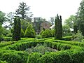
Ruins of the original Barnsley Gardens home and surrounding garden foliage

See Also
 In Spanish: Adairsville para niños
