Adams County, Idaho facts for kids
Quick facts for kids
Adams County
|
||
|---|---|---|

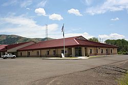
Adams County Courthouse
|
||
|
||

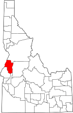
Location within the U.S. state of Idaho
|
||
 Idaho's location within the U.S. |
||
| Country | ||
| State | ||
| Founded | March 3, 1911 | |
| Named for | John Adams | |
| Seat | Council | |
| Largest city | Council | |
| Area | ||
| • Total | 1,370 sq mi (3,500 km2) | |
| • Land | 1,363 sq mi (3,530 km2) | |
| • Water | 6.7 sq mi (17 km2) 0.5% | |
| Population
(2020)
|
||
| • Total | 4,379 | |
| • Estimate
(2023)
|
4,903 |
|
| • Density | 3.196/sq mi (1.234/km2) | |
| Time zone | UTC−7 (Mountain) | |
| • Summer (DST) | UTC−6 (MDT) | |
| Congressional district | 1st | |
Adams County is a quiet, countryside area, also known as a county, located in the state of Idaho. In 2020, about 4,379 people lived here. This makes it one of the least populated counties in Idaho.
The main town and biggest city in Adams County is Council. The county was created in 1911. It was named after John Adams, who was the second President of the United States.
Adams County is a great place for outdoor activities. It has two popular ski areas: Brundage Mountain near New Meadows, and the Little Ski Hill close to McCall.
Contents
Geography
Adams County is located in western Idaho. Its western border touches the state of Oregon. The Snake River flows along this border.
The county covers a total area of about 1,370 square miles (3,500 km²). Most of this area, about 1,363 square miles (3,530 km²), is land. Only a small part, about 6.7 square miles (17 km²), is water.
Neighboring Counties
Adams County shares its borders with several other counties:
- Idaho County - to the north
- Valley County - to the east
- Gem County - to the southeast
- Washington County - to the south
- Baker County, Oregon - to the southwest (in Oregon)
- Wallowa County, Oregon - to the northwest (in Oregon)
Main Roads
Two important highways run through Adams County:
Protected Natural Areas
Parts of these beautiful natural areas are found in Adams County:
- Hells Canyon National Recreation Area
- Payette National Forest
Population Information
| Historical population | |||
|---|---|---|---|
| Census | Pop. | %± | |
| 1920 | 2,966 | — | |
| 1930 | 2,867 | −3.3% | |
| 1940 | 3,407 | 18.8% | |
| 1950 | 3,347 | −1.8% | |
| 1960 | 2,978 | −11.0% | |
| 1970 | 2,877 | −3.4% | |
| 1980 | 3,347 | 16.3% | |
| 1990 | 3,254 | −2.8% | |
| 2000 | 3,476 | 6.8% | |
| 2010 | 3,976 | 14.4% | |
| 2020 | 4,379 | 10.1% | |
| 2023 (est.) | 4,903 | 23.3% | |
| US Decennial Census 1790–1960, 1900–1990, 1990–2000, 2010–2020 2020 |
|||
In 2010, there were 3,976 people living in Adams County. Most residents were white (96.1%). About 2.4% of the population was of Hispanic or Latino background. The average age of people living in the county was 50 years old.
Communities
Adams County has a few cities and many smaller, unincorporated communities.
Cities
Unincorporated Communities
These are smaller places that are not officially organized as cities:
- Alpine
- Bear
- Beer Bottle Crossing
- Cuprum
- Devils Ladder
- Fruitvale
- Glendale
- Goodrich
- Helena
- Indian Valley
- Meadows
- Mesa
- Pine Ridge
- Starkey
- Tamarack
- Wildhorse
- Woodland
Population of Cities
Here are the populations of the cities in Adams County, based on the 2010 census. † county seat
| Rank | City/Town/etc. | Municipal type | Population (2010 Census) |
|---|---|---|---|
| 1 | † Council | City | 839 |
| 2 | New Meadows | City | 438 |
Education
Several school districts serve the students in Adams County:
- Cambridge Joint School District 432
- Council School District 13
- McCall-Donnelly Joint School District 421
- Meadows Valley School District 11
- Salmon River School District 243
For higher education, residents are near the College of Western Idaho.
Healthcare
Healthcare services for the county are provided by the Southwest Idaho Health District.
See also
 In Spanish: Condado de Adams (Idaho) para niños
 | Victor J. Glover |
 | Yvonne Cagle |
 | Jeanette Epps |
 | Bernard A. Harris Jr. |


