New Meadows, Idaho facts for kids
Quick facts for kids
New Meadows, Idaho
|
|
|---|---|

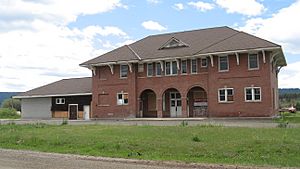
PIN Railroad Depot in 2007
|
|

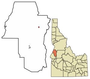
Location of New Meadows in Adams County, Idaho.
|
|
| Country | United States |
| State | Idaho |
| County | Adams |
| Area | |
| • Total | 0.59 sq mi (1.54 km2) |
| • Land | 0.58 sq mi (1.51 km2) |
| • Water | 0.01 sq mi (0.03 km2) |
| Elevation | 3,868 ft (1,179 m) |
| Population
(2010)
|
|
| • Total | 496 |
| • Density | 919.52/sq mi (354.78/km2) |
| Time zone | UTC-7 (Mountain (MST)) |
| • Summer (DST) | UTC-6 (MDT) |
| ZIP code |
83654
|
| Area code(s) | 208, 986 |
| FIPS code | 16-56890 |
| GNIS feature ID | 2411234 |
New Meadows is a small city in Adams County, Idaho, in the United States. It's located in a beautiful valley called Meadows Valley, right by the Little Salmon River. This city is in the west-central part of Idaho. In 2010, about 496 people lived there. New Meadows is an important meeting point for two main highways: U.S. Route 95 and State Highway 55. These roads connect it to other towns like McCall and Boise.
Contents
History of New Meadows
Before 1911, the area where New Meadows is now was part of Washington County. The town of Meadows was already there, with its own newspaper.
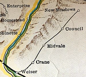
The city of New Meadows was officially started in 1911. It grew up around the end of a railroad line called the Pacific and Idaho Northern (PIN) Railroad. This railroad ran from Weiser to an area just outside the old town of Meadows. Without this railroad, New Meadows might not even exist today!
The Historic PIN Railroad Depot
The main train station, called the depot, was built in 1910. It was the northern end of the PIN Railroad. This building is very important to the history and culture of the area. It's located right where US-95 and State Highway 55 meet.
The depot is so important that it's listed on the National Register of Historic Places. Today, it's used as a community center for New Meadows. It even hosted a special traveling exhibit from the Smithsonian Institution in 2005.
The PIN Railroad was a "farm-to-market" railroad until 1940. This meant it helped farmers get their goods to sell. Later, it was used to transport timber from local logging companies.
The Union Pacific company took over the line in 1936. But in 1979, they stopped using the northern part of the line, including the section that went to New Meadows. The depot stopped being a working train station in 1972. In 1978, a local historical society took over the depot to save it. They wanted to use it to store the history of Adams County. Since 2000, the building has been fixed up with a new foundation and roof.
Education in New Meadows
New Meadows has one school called the Meadows Valley School. This school is special because it has all thirteen grades, from kindergarten all the way to 12th grade, in one building! The school's mascot is the mountaineer, and their school colors are orange and black.
Fun Things to Do in New Meadows
There are lots of fun things to do around New Meadows, especially if you love the outdoors!
- Skiing: Two places to go skiing are nearby: Brundage Mountain and the Little Ski Hill. They are both less than 10 miles (16 km) to the east.
- Golf: If you like golf, you can visit the MeadowCreek golf resort. It's just a few miles northwest of town.
- Lakes and Rivers: Payette Lake in McCall offers many chances for outdoor fun. Further north, Riggins is known as the gateway to the Salmon River and the amazing Seven Devils Mountains.
- Hot Springs: About 5 miles (8 km) north of New Meadows, you can relax at Zim's Hot Springs.
Highways Connecting New Meadows
New Meadows is about 115 miles (185 km) north of Boise. You can get there by taking State Highway 55, which is also known as the Payette River Scenic Byway. This road is a special national scenic byway because of its beautiful views.
The byway starts south of New Meadows and follows the whitewater of the Payette River. It goes through towns like Cascade and McCall. The route then turns west at Payette Lake in McCall and ends right in New Meadows, where it meets U.S. Route 95.
Geography and Climate
New Meadows covers a total area of about 0.53 square miles (1.37 km²). Most of this area is land, with only a small part being water.
New Meadows Climate
New Meadows has a type of continental climate that gets warm summers. It's known as "Dsb" on climate maps.
The hottest temperature ever recorded in New Meadows was 104°F (40°C). This happened on three different dates: August 9, 1906, July 19, 1960, and July 13, 2002. The coldest temperature ever recorded was a very chilly -49°F (-45°C) on December 13, 1919.
| Climate data for New Meadows, Idaho, 1991–2020 normals, extremes 1905–2020 | |||||||||||||
|---|---|---|---|---|---|---|---|---|---|---|---|---|---|
| Month | Jan | Feb | Mar | Apr | May | Jun | Jul | Aug | Sep | Oct | Nov | Dec | Year |
| Record high °F (°C) | 56 (13) |
62 (17) |
73 (23) |
87 (31) |
93 (34) |
101 (38) |
104 (40) |
104 (40) |
97 (36) |
89 (32) |
72 (22) |
64 (18) |
104 (40) |
| Mean maximum °F (°C) | 42.0 (5.6) |
47.5 (8.6) |
60.4 (15.8) |
72.5 (22.5) |
81.3 (27.4) |
88.9 (31.6) |
95.9 (35.5) |
95.4 (35.2) |
89.8 (32.1) |
77.7 (25.4) |
58.5 (14.7) |
44.1 (6.7) |
96.9 (36.1) |
| Mean daily maximum °F (°C) | 30.0 (−1.1) |
36.2 (2.3) |
45.1 (7.3) |
54.6 (12.6) |
63.8 (17.7) |
72.2 (22.3) |
84.8 (29.3) |
84.6 (29.2) |
74.7 (23.7) |
57.9 (14.4) |
41.9 (5.5) |
30.7 (−0.7) |
56.4 (13.5) |
| Daily mean °F (°C) | 19.7 (−6.8) |
24.1 (−4.4) |
33.0 (0.6) |
40.9 (4.9) |
48.6 (9.2) |
55.7 (13.2) |
64.0 (17.8) |
62.7 (17.1) |
53.8 (12.1) |
42.0 (5.6) |
30.6 (−0.8) |
21.7 (−5.7) |
41.4 (5.2) |
| Mean daily minimum °F (°C) | 9.4 (−12.6) |
12.1 (−11.1) |
20.8 (−6.2) |
27.2 (−2.7) |
33.4 (0.8) |
39.1 (3.9) |
43.3 (6.3) |
40.7 (4.8) |
32.9 (0.5) |
25.2 (−3.8) |
19.3 (−7.1) |
12.6 (−10.8) |
26.3 (−3.2) |
| Mean minimum °F (°C) | −16.1 (−26.7) |
−10.4 (−23.6) |
1.8 (−16.8) |
16.1 (−8.8) |
20.9 (−6.2) |
28.3 (−2.1) |
33.2 (0.7) |
30.5 (−0.8) |
21.9 (−5.6) |
12.3 (−10.9) |
1.0 (−17.2) |
−13.1 (−25.1) |
−22.2 (−30.1) |
| Record low °F (°C) | −43 (−42) |
−44 (−42) |
−29 (−34) |
−2 (−19) |
12 (−11) |
19 (−7) |
20 (−7) |
18 (−8) |
11 (−12) |
−7 (−22) |
−34 (−37) |
−49 (−45) |
−49 (−45) |
| Average precipitation inches (mm) | 2.85 (72) |
2.00 (51) |
2.51 (64) |
2.01 (51) |
2.35 (60) |
2.08 (53) |
0.70 (18) |
0.56 (14) |
1.01 (26) |
1.83 (46) |
2.55 (65) |
4.05 (103) |
24.50 (622) |
| Average snowfall inches (cm) | 18.0 (46) |
10.5 (27) |
3.9 (9.9) |
0.9 (2.3) |
0.1 (0.25) |
0.0 (0.0) |
0.0 (0.0) |
0.0 (0.0) |
0.0 (0.0) |
0.2 (0.51) |
4.4 (11) |
18.6 (47) |
56.6 (143.96) |
| Source 1: NOAA | |||||||||||||
| Source 2: National Weather Service | |||||||||||||
Population of New Meadows
| Historical population | |||
|---|---|---|---|
| Census | Pop. | %± | |
| 1920 | 141 | — | |
| 1930 | 220 | 56.0% | |
| 1940 | 264 | 20.0% | |
| 1950 | 621 | 135.2% | |
| 1960 | 647 | 4.2% | |
| 1970 | 605 | −6.5% | |
| 1980 | 576 | −4.8% | |
| 1990 | 534 | −7.3% | |
| 2000 | 533 | −0.2% | |
| 2010 | 496 | −6.9% | |
| 2019 (est.) | 537 | 8.3% | |
| U.S. Decennial Census | |||
The population of New Meadows has changed over the years. In 1920, only 141 people lived there. The population grew quite a bit by 1950, reaching 621 people. In 2010, the population was 496.
What the 2010 Census Tells Us
In 2010, the census counted 496 people living in New Meadows. These people lived in 201 households. Most of the people (95.4%) were White. A small number were Native American or from other backgrounds. About 4.8% of the population identified as Hispanic or Latino.
About one-third of the households (34.3%) had children under 18 living with them. Many households (51.2%) were married couples living together. The average age of people in New Meadows was about 35.9 years old.
Notable Residents
- Gilbert F. Smith was a state legislator (someone who helps make laws for the state) and the president of Meadows Valley Bank.
See also
 In Spanish: New Meadows para niños
 | Delilah Pierce |
 | Gordon Parks |
 | Augusta Savage |
 | Charles Ethan Porter |


