All Saints' Church, Shuart facts for kids
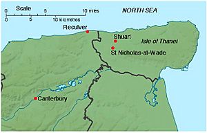
All Saints' Church, Shuart (pronounced "Show-art"), was an old church in the north-west of the Isle of Thanet, Kent, England. It was built a very long time ago, during the Anglo-Saxon period, as a small church (called a chapel of ease) for a bigger church in Reculver. Back then, the Isle of Thanet was separated from the mainland by a sea channel called the Wantsum Channel. The last church building on this spot was taken down by the early 1600s. Today, you can't see any signs of it above ground.
People lived in the Shuart area since the Bronze Age. In the 600s, land in the west of the Isle of Thanet was given to the church at Reculver. All Saints' Church stayed as a chapel for Reculver until the early 1300s. At that time, the Reculver area was split into new parishes for Herne and St Nicholas-at-Wade. The area that All Saints' served became part of the St Nicholas-at-Wade parish, with All Saints' as its chapel. Both churches still had a connection to Reculver and made yearly payments to it.
The original All Saints' Church had a main hall (nave) and a special area for the altar (chancel). It was made bigger several times between the 900s and 1300s as more people moved to the area. It grew to include side sections (aisles), a tower, and a northern chapel. Its windows had beautiful stained glass. The church was left empty in the 1400s, probably because the local community couldn't afford to keep two churches going. It was then taken apart, and most of its stones were removed. Some of these stones might have been used to improve the church of St Nicholas. The settlement of Shuart continued to be used for local administration until the 1600s, but it is now known as a deserted medieval village. By 1723, there were no visible remains of All Saints' Church. However, the land where it stood still belonged to the St Nicholas parish. Archaeologists dug up the site of All Saints' Church between 1978 and 1979. They found the foundations, which helped them understand how the building was built and what it looked like. They also found stone carvings, floor tiles, pieces of stained glass, and some old graves.
Contents
The Church's Beginning
The name "Shuart" comes from an old Anglo-Saxon word meaning a piece of land that is "skirted" or "cut off". The earliest signs of people living at Shuart are from the Bronze Age. Archaeologists found a Bronze Age enclosure near the church site and a collection of Bronze Age objects, called the "Shuart Hoard," in the 1980s. People continued to live there through the Iron Age and the Roman period. Buildings, pottery, glass, and even human burials from these times have been found nearby.
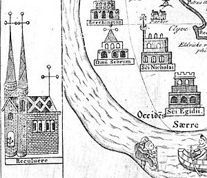
The history of the site during the Anglo-Saxon period began in the 600s. The Isle of Thanet was divided into eastern and western parts. Land in the west, called Westanea, was given to the monastery at Reculver by King Hlothhere of Kent in 679. This division of the island was still important in the early 1400s, as shown on a map by Thomas Elmham.
The monastery at Reculver was set up in 669. It became a very important and wealthy center. By the 900s, it came under the control of the archbishops of Canterbury. King Eadred of England gave the Reculver estate to Christ Church, Canterbury (now Canterbury Cathedral), in 949. This gift included land in the west of the Isle of Thanet. Even though Shuart and St Nicholas-at-Wade are not named in the Domesday Book of 1086, they were likely part of the Reculver entry, which was held by the Archbishop of Canterbury.
The Church and Its Community
A church named All Saints was built at Shuart sometime between 679 and the 900s. It might have been built because Reculver was the main church for the area, or it could have been built after Christ Church, Canterbury, gained land there in the mid-900s. Archaeologists haven't been able to find a more exact date. However, All Saints' Church was standing for about 100 years or more before the church at St Nicholas-at-Wade was built, which was likely in the late 1000s.
The First Church Building
The first All Saints' Church was a rectangular building. It was about 52.5 feet (16 meters) long and 15.75 feet (4.8 meters) wide. It had a main hall (nave) at the west end and a special area for the altar (chancel) at the east end. A sanctuary was added to the very east end of the chancel during the first building phase. The chancel was about 16.4 feet (5 meters) long. The nave was smaller, only about 9.2 feet (2.8 meters) of the total length. A narrow passageway connected them. We don't know how many people this first church served. The Domesday Book in 1086 recorded 90 villeins (farmers who worked for a lord) and 25 bordars (small farmers) in the Reculver manor, which included land on the Isle of Thanet. These numbers only count adult male heads of households, so the actual population would have been much larger.
Making the Church Bigger
The church was made bigger in a second building phase between the 900s and 1000s. The west wall was taken down, and the nave was extended by 16.5 feet (5 meters). The passageway to the chancel was also opened up. A third phase happened in the 1100s when the nave was rebuilt to be much larger. It now had side sections (aisles) on the north and south, each with four columns. This new nave was about 30 feet (9.1 meters) wide and 42 feet (12.8 meters) long.
A tower, about 16.2 feet (4.9 meters) square, was added to the west end of the church either during this time or in a fourth phase in the 1200s. This fourth phase also included putting in new windows with stained glass, especially at the east end of the nave. A chapel was also added to the north side of the church. It was about 12.5 feet (3.8 meters) wide and 29.4 feet (8.9 meters) long, with an altar at its east end. It had square floor tiles. Tiles from Flanders (a region in modern-day Belgium) were also put in the church, probably in the 1400s.
The church's expansion happened during a time when the population of Reculver parish was growing. By the late 1200s, there were more than 3,000 people. The first time All Saints' Church was specifically mentioned was in 1284. The local community complained to the archbishop that the priest (vicar) of Reculver had not provided a chaplain to hold daily mass. In 1310, Archbishop Robert Winchelsey of Canterbury made St Nicholas-at-Wade a separate parish, with All Saints' Church as its chapel. It was served by a vicar and an assistant priest. This change happened because the Reculver parish had grown so large that one priest was not enough. Also, it was inconvenient for people on the Isle of Thanet to travel to the main church at Reculver.
However, the new vicar of St Nicholas-at-Wade still had to pay £3.3s.4d (about £3.17) each year to the vicar of Reculver "as a sign of subjection." This was a large amount of money back then. The vicar also had to go to Reculver in a procession with his assistant priest and parishioners every year on Whit Monday (the eighth day after Easter). They also had to be there for the Nativity of the Virgin Mary on September 8th, who was the patron saint of Reculver. These visits continued into the mid-1500s. The parish of St Nicholas-at-Wade was still making annual payments to Reculver in the 1800s.
The Church's Decline

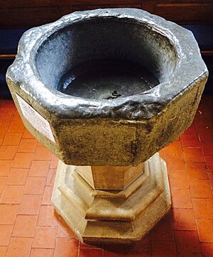
Thomas Elmham's map from the early 1400s shows All Saints' Church with its tower. But a map from 1596 by Philip Symonson, which showed churches "as they actually appeared," showed a church without a tower. Digging up the church's foundations suggests it was probably a ruin by the mid-1400s and was taken down. It might have been replaced by a smaller building without a tower about 20 years later. It's possible that stones from All Saints' Church were used to build a new upper section (clerestory) for the nave of St Nicholas' church in the late 1400s. The old baptismal font now in Reculver's parish church of St Mary the Virgin at Hillborough probably came from All Saints'.
By 1630, there was no church left. In that year, the vicar and churchwardens of St Nicholas-at-Wade reported that there was a piece of land called "Allhallows close," where the chapel of All Saints used to stand. In 1723, an old historian named John Lewis wrote that the church was "now so entirely demolished... that there are no marks of either of them."
The decline of All Saints' Church and the community of Shuart might have started with the Black Death in 1348–49. The population of England dropped by about 40% during that time. Also, the nearby Wantsum Channel began to close up. This channel had been a popular route for sea trade between England and Europe in medieval times, bringing a lot of wealth to Kent. But it slowly became blocked by silt. By the end of the 1400s, ships could no longer use the Wantsum Channel. By the mid-1500s, the northern part near Shuart was just a small creek.
The church was probably abandoned because it was too expensive to maintain two churches (All Saints and St Nicholas) in what had become a "remote, rural parish." Shuart was still mentioned in tax records in the 1600s. In 1624, it was taxed as a "vill" (a small village). However, the parish as a whole was shrinking. By 1563, the parish of St Nicholas-at-Wade was the second smallest on the Isle of Thanet, with only 33 households. By 1800, there were even fewer. By 1723, the settlement of Shuart was only a historical record. John Lewis wrote that it seemed like a "Vill or Town" once belonged to the chapel of All Saints. The only building Lewis recorded was a "good farm house." This farmhouse was built in the late 1600s and still stands today. But otherwise, Shuart is now considered a deserted medieval village.
Archaeological Digs
The site of All Saints' Church, Shuart, was marked on Ordnance Survey maps in the 1800s. Its location was confirmed in the mid-1900s using aerial photography by Kenneth St Joseph. The site is on farmland owned by St John's College, Cambridge, and it was dug up by the Thanet Archaeological Unit between 1978 and 1979 with the college's permission.
The only parts of the main church structure that survived were its foundations, which were made of packed chalk. However, these foundations still allowed archaeologists to figure out how the building was constructed over time. They also found various pieces of the building, including mortar flooring, glazed floor tiles, and different types of stone like green sandstone, Caen stone, and Quarr stone from the Isle of Wight. Pieces of stained glass were also found. Among the stone fragments were many carvings, including "two small delicately carved pieces of foliage which are certainly twelfth-century work." Some mortar fragments had the imprints of barnacles, which showed that some of the stone used in the church had been brought from the shoreline.
A number of graves were also discovered. One of them was covered by an unmarked stone. However, the graves had been disturbed and filled with rubble containing pieces of human bone. Two of the graves were dug between the time the church was taken down and when a smaller, short-lived replacement was built in the 1400s. Almost all of the church's structure had been taken away, probably to be used in other buildings. Much of what was left had been destroyed by ploughing over the years.
 | Leon Lynch |
 | Milton P. Webster |
 | Ferdinand Smith |


